Neighborhood of Philadelphia in Philadelphia, Pennsylvania
Lower North Philadelphia
Neighborhood of Philadelphia
Lower North Philadelphia at Montgomery Avenue and 18th Street
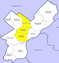
Map of Philadelphia County with North Philadelphia highlighted. Click for larger image
Country
United States of America
State
Pennsylvania
County
Philadelphia
City
Philadelphia
Area
• Total
2.3 sq mi (6 km2)
Population
(2010)
• Total
59,250
• Density
14,736/sq mi (5,690/km2)
ZIP code
19121, 19122, 19123, 19130, 19133
Lower North Philadelphia is a section of Philadelphia, Pennsylvania, that is immediately north of Center City and below Upper North Philadelphia and can be described as a section of Philadelphia that was designated as a "Model City" target, that has overcome poverty and blight through key developments and a recipient of a federal funded program in 1966 to improve the neighborhood and extend the Center City district north of City Hall.[1] It also contains the Lower North Philadelphia Speculative Housing Historic District along Cecil B. Moore Avenue.
Lower North Philadelphia consists of the Brewerytown, Cecil B. Moore,
Cabot, Fairhill, Francisville, Hartranft, Ludlow, North Central, Poplar, Sharswood, Spring Garden, South Lehigh, Stanton, Strawberry Mansion, Yorktown, Fairmount and Northern Liberties neighborhoods.
^Carolyn Teich Adams (2 November 1988). The Politics of Capital Investment: The Case of Philadelphia. ISBN 9780887068485.
and 16 Related for: Lower North Philadelphia information
LowerNorthPhiladelphia is a section of Philadelphia, Pennsylvania, that is immediately north of Center City and below Upper NorthPhiladelphia and can...
to south) Olney-Oak Lane, Upper NorthPhiladelphia and LowerNorthPhiladelphia. Other sections of NorthPhiladelphia include Brewerytown, Fairhill, Fairmount...
Fairmount Park LowerNorthPhiladelphia is a section of Philadelphia that is immediately north of Center City and below Upper NorthPhiladelphia and can be...
which were inherited from the former Philadelphia Transportation Company, and originally built by the Philadelphia Rapid Transit Company. It also includes...
The LowerNorthPhiladelphia Speculative Housing Historic District, also known as the Cecil B. Moore Redevelopment Area, is a national historic district...
Philadelphia, commonly referred to as Philly, is the most populous city in the U.S. state of Pennsylvania. Philadelphia is the nation's sixth-most populous...
NorthPhiladelphia station is an intercity rail and regional rail station on the Northeast Corridor, located on North Broad Street in the North Philadelphia...
Pennsylvania. It is located at 2601 North Broad Street (PA 611) in the Cecil B. Moore section of LowerNorthPhiladelphia, and serves the Lansdale/Doylestown...
The Philadelphia Badlands is a section of NorthPhiladelphia and Lower Northeast Philadelphia in Philadelphia, Pennsylvania that is known for an abundance...
complex in the Sharswood neighborhood of Philadelphia, Pennsylvania. Owned and operated by the Philadelphia Housing Authority, they were viewed by many...
Northwest Philadelphia is a section of the city of Philadelphia. The official boundary is Stenton Avenue to the north, the Schuylkill River to the southwest...
Lower Moyamensing is a neighborhood in South Philadelphia, Pennsylvania, United States, situated just south of the East Passyunk Crossing neighborhood...
Wikimedia Commons has media related to Museums in Philadelphia. This list of museums in Philadelphia, Pennsylvania, encompasses museums defined for this...
Broad and Berks Street in NorthPhiladelphia, Pennsylvania from 1837 to 1956. It was the second rural cemetery in Philadelphia after Laurel Hill Cemetery...
 Global Information