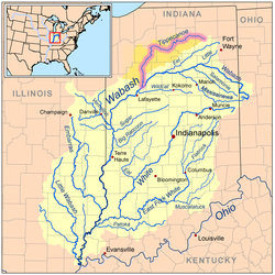
Map of the Wabash River watershed with the Tippecanoe River highlighted.
Location
Country
US
Physical characteristics
Source
• location
Crooked Lake in Noble County, Indiana
Mouth
• location
Wabash River near Battle Ground, Indiana
Length
182 miles (293 km)
Basin size
1,875 sq mi (4,860 km2)
Discharge
• average
5,110 cu ft/s (145 m3/s)
Basin features
Progression
Wabash → Ohio → Mississippi → Gulf of Mexico
The Tippecanoe River (/ˌtɪpikəˈnuː/TIP-ee-kə-NOO) is a gentle, 182-mile-long (293 km)[1] river in the Central Corn Belt Plains ecoregion in northern Indiana. It flows from Crooked Lake in Noble County to the Wabash River near what is now Battle Ground, about 12 miles (19 km) northeast of Lafayette. The name "Tippecanoe" was derived from a Miami-Illinois word for buffalo fish, reconstructed as */kiteepihkwana/[2] or as kiteepihkwana siipiiwi.[3]
The Tippecanoe River is fed by 88 natural lakes and has a drainage area of 1,250,000 acres (5,100 km2), spanning 14 counties. It supports more numerous imperiled species and overall species diversity than most streams of the upper Midwest.[4] The Nature Conservancy has identified it as one of the top ten rivers in the United States to preserve due to its ecological diversity and the high proportion of endangered species found in it.[4]
^U.S. Geological Survey. National Hydrography Dataset high-resolution flowline data. The National Map, accessed May 19, 2011
^Bright, William (2004). Native American placenames of the United States. University of Oklahoma Press. p. 496. ISBN 978-0-8061-3598-4. Retrieved 11 April 2011.
^"myaamiaatawaakani | Myaamia Dictionary River names". Archived from the original on 2017-08-30. Retrieved 2017-05-09.
^ ab"All about fishing on the Tippecanoe River". The Nature Conservancy. Archived from the original on November 17, 2016. Retrieved April 18, 2014.
The TippecanoeRiver (/ˌtɪpikəˈnuː/ TIP-ee-kə-NOO) is a gentle, 182-mile-long (293 km) river in the Central Corn Belt Plains ecoregion in northern Indiana...
unincorporated town Tippecanoe County, Indiana TippecanoeRiver in Indiana TippecanoeRiver State Park in Indiana Tippecanoe Township (disambiguation), five in Indiana...
at the Ohio River, the Wabash flows freely for 411 miles (661 km) The TippecanoeRiver, White River, Embarras River and Little Wabash River are major tributaries...
headquarters at Prophetstown, near the confluence of the TippecanoeRiver and the Wabash River. Tecumseh was not yet ready to oppose the United States...
River, the St. Joseph River, the Kankakee River, Tippecanoe and Wabash Rivers, the Illinois River and Lake Peoria, and the Des Plaines and Fox Rivers...
Tippecanoe Lake is a large, glacially created lake in Leesburg, Kosciusko County, Indiana and, at 123 feet (37 m) deep, is the deepest natural lake in...
Prophetstown Shades Shakamak Spring Mill Summit Lake TippecanoeRiver Turkey Run Versailles White River Whitewater Memorial The U.S. state of Indiana has...
TippecanoeRiver is a state park in Pulaski County, Indiana, United States. It is located 58 miles (93 km) south-southwest of South Bend, Indiana. It was...
schools. It also heavily damaged the Penn Central bridge over the TippecanoeRiver. Overall damage according to the NOAA was estimated at US$250 million...
Lake, Kosciusko County. TippecanoeRiverTippecanoe Township, Kosciusko County, Indiana is named for TippecanoeRiver. Tippecanoe Township, Carroll County...
(Wabash River tributary), also called Sugar River, Rock River Little Vermilion River Vermilion River Big Pine Creek Wildcat Creek TippecanoeRiver Redinger...
in the 1920s when two dams were built outside of Monticello on the TippecanoeRiver. It remains a popular recreational area and helps generate an estimated...
against Tecumseh's confederacy at the Battle of Tippecanoe in 1811, where he earned the nickname "Old Tippecanoe". He was promoted to major general in the Army...
of the TippecanoeRiver (Kiteepihkwana siipiiwi) (″River of the buffalo fish″) (east of Old Tip Town, Indiana) to its mouth into the Wabash River (Waapaahšiki...
began in 1923 and was completed in 1925, damming the waters of the TippecanoeRiver. The earthen dam is 58 feet (18 m) high, has a maximum capacity of...
the Great Lakes. In three treaties signed in October 1832, at the TippecanoeRiver north of Rochester, Indiana, the Potawatomi ceded to the federal government...
Mississinewa River, Eel River, TippecanoeRiver, White River, Vermilion River, and Embarras River drain Central Indiana. The Iroquois and Kankakee Rivers begin...
against Tecumseh's Confederacy; the U.S. gained victory at the Battle of Tippecanoe on November 7, 1811. Tecumseh was killed in 1813 during the Battle of...
USNS Tippecanoe (T-AO-199) is a Henry J. Kaiser-class underway replenishment oiler operated by the Military Sealift Command (MSC) to support ships of the...
of the bridge was a ford across the TippecanoeRiver. The Yellowstone Trail passed on the south side of the river. A marker has been maintained at this...
culture from the territory. Located near the juncture of two rivers, the Wabash and TippecanoeRivers, Prophetstown gained significance as a central point in...
starts near Argos and joins the TippecanoeRiver in Talma. Other than those two towns, it is also near Walnut, Tiosa, Tippecanoe, Old Tip Town, Mentone, and...
Indiana, is a village about a mile east of the site of the Battle of Tippecanoe in 1811, a crucial battle in Tecumseh's War which ultimately led to the...
 Global Information