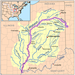
Wabash River catchment with the Wabash River highlighted.
Location
Country
US
States
Ohio Indiana Illinois
Physical characteristics
Source
• location
Near Fort Recovery in Mercer County, Ohio
Mouth
• location
Ohio River near Shawneetown, Illinois
Length
503 mi (810 km)
Basin size
33,100 sq mi (86,000 km2)
Discharge
• average
35,350 cu ft/s (1,001 m3/s) for mouth[1]
Basin features
Progression
Wabash River → Ohio → Mississippi → Gulf of Mexico
Tributaries
• left
Salamonie River, Mississinewa River, Wildcat Creek, Sugar Creek, Big Raccoon Creek, White River, Patoka River
• right
Little River, Eel River, Tippecanoe River, Vermilion River, Little Vermilion River, Embarras River, Little Wabash River
The Wabash River/ˈwɔːbæʃ/ (French: Ouabache) is a 503-mile-long (810 km)[2] river that drains most of the state of Indiana, and a significant part of Illinois, in the United States. It flows from the headwaters in Ohio, near the Indiana border, then southwest across northern Indiana turning south near the Illinois border, where the southern portion forms the Indiana-Illinois border before flowing into the Ohio River.
It is the largest northern tributary of the Ohio River and third largest overall, behind the Cumberland and Tennessee rivers. From the dam near Huntington, Indiana, to its terminus at the Ohio River, the Wabash flows freely for 411 miles (661 km) The Tippecanoe River, White River, Embarras River and Little Wabash River are major tributaries. The river's name comes from a Miami word meaning "water over white stones", as its bottom is white limestone, now obscured by mud.
The Wabash is the state river of Indiana, and subject of the state song "On the Banks of the Wabash, Far Away" by Paul Dresser. Two counties (in Indiana and Illinois); eight townships in Illinois, Indiana, and Ohio; one Illinois precinct, one city, one town, two colleges, one high school, one canal, one former class I railroad, several bridges and avenues are all named for the river itself while four US Navy warships are either named for the river or the numerous battles that took place on or near it.
^Benke, Arthur C.; Cushing, Colbert E. (6 September 2011). Rivers of North America. Elsevier. ISBN 9780080454184. Retrieved 4 April 2018 – via Google Books.
^U.S. Geological Survey. National Hydrography Dataset high-resolution flowline data. The National Map, accessed May 13, 2011
The WabashRiver /ˈwɔːbæʃ/ (French: Ouabache) is a 503-mile-long (810 km) river that drains most of the state of Indiana, and a significant part of Illinois...
The Wabash and Erie Canal was a shipping canal that linked the Great Lakes to the Ohio River via an artificial waterway. The canal provided traders with...
the valley of the Lower WabashRiver, along the state line between southeastern Illinois and southwestern Indiana. The Wabash Valley Seismic Zone consists...
Wabash may refer to: Wabash Confederacy, or Wabash Indians, a loose confederacy of 18th century Native Americans WabashRiver, in Ohio, Indiana and Illinois...
passenger-miles.[citation needed] The source of the Wabash name was the WabashRiver, a 475-mile (764 km)-long river in the eastern United States that flows southwest...
and northeast, Ohio to the east, the Ohio River and Kentucky to the south and southeast, and the WabashRiver and Illinois to the west. It is the 38th-largest...
of Cincinnati, Ohio. By far the largest watershed in the state, the WabashRiver drainage area contains the several large cities, including Indianapolis...
River, the St. Joseph River, the Kankakee River, Tippecanoe and WabashRivers, the Illinois River and Lake Peoria, and the Des Plaines and Fox Rivers...
Canal and the Calumet River in Illinois) Deep River Ohio RiverWabashRiver Black River Bonpas Creek Patoka River White River Eagle Creek Little Eagle...
water basin of the WabashRiver; the other rivers (not including the Ohio River) are tributaries of the WabashRiver. The Vermillion River (and its forks)...
Tennessee River 70,575 cu ft (1,998.5 m3)/sec Cumberland River 37,250 cu ft (1,055 m3)/sec WabashRiver 35,350 cu ft (1,001 m3)/sec Allegheny River 19,750 cu ft...
City, Indiana) down to its mouth at the WabashRiver (Waapaahšiki Siipiiwi) (″Shining White River/Bright Shiny River″) (near Logansport, Indiana) in northern...
"The Great Rock Island Route", popularized as "Wabash Cannonball" and various other titles, is a 19th-century American folk song that describes the scenic...
The 1909 WabashRiver earthquake occurred at 04:45 local time on September 27 with a maximum Mercalli intensity of VII (Very strong). It measured 5.1 on...
American villagers in the area of the WabashRiver in what are now the U.S. states of Illinois, Indiana, and Ohio. The Wabash Indians were primarily the Miami...
The Wabash Valley is a region located in sections of both Illinois and Indiana. It is named for the WabashRiver and, as the name is typically used, spans...
coordinates) Note: The Little River of northeastern Indiana is also sometimes known as the Little WabashRiver. The Little WabashRiver is a 240-mile-long (390 km)...
 Global Information