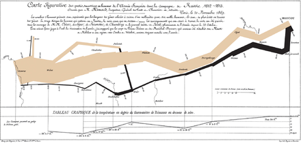
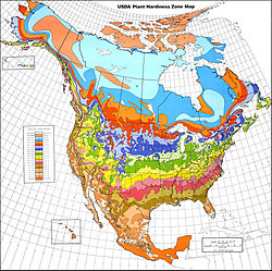
Minard's 1869 flow map of Napoleon's invasion of Russia in 1812–1813. A very innovative thematic map from the 19th century.Isarithmic map of minimum temperature used as plant hardiness zones.
A thematic map is a type of map that portrays the geographic pattern of a particular subject matter (theme) in a geographic area. This usually involves the use of map symbols to visualize selected properties of geographic features that are not naturally visible, such as temperature, language, or population.[1] In this, they contrast with general reference maps, which focus on the location (more than the properties) of a diverse set of physical features, such as rivers, roads, and buildings.[2][3] Alternative names have been suggested for this class, such as special-subject or special-purpose maps, statistical maps, or distribution maps, but these have generally fallen out of common usage.[4][5] Thematic mapping is closely allied with the field of Geovisualization.
Several types of thematic maps have been invented, starting in the 18th and 19th centuries, as large amounts of statistical data began to be collected and published, such as national censuses. These types, such as choropleth maps, isarithmic maps, and chorochromatic maps, use very different strategies for representing the location and attributes of geographic phenomena, such that each is preferable for different forms of phenomena and different forms of available data. A wide variety of phenomena and data can thus be visualized using thematic maps, including those from the natural world (e.g., climate, soils) and the human world (e.g., demographics, public health)
^Bartz Petchenik, Barbara (April 1979). "From Place to Space: The Psychological Achievement of Thematic Mapping". Cartography and Geographic Information Science. 6 (1): 5–12. doi:10.1559/152304079784022763.
^Thrower, Norman J.W. (2008). Maps and Civilization: Cartography in Culture and Society (3rd ed.). University of Chicago Press. p. 95. ISBN 9780226799759.
^"Fundamentals of Mapping". icsm.gov.au. Retrieved 2015-05-03.
^Dent, Borden D.; Torguson, Jeffrey S.; Hodler, Thomas W. (2009). Cartography: Thematic Map Design. McGraw-Hill. p. 7. ISBN 978-0-07-294382-5.
^Keates, John S. (1973). Cartographic design and production. Longman. p. 59.
A thematicmap is a type of map that portrays the geographic pattern of a particular subject matter (theme) in a geographic area. This usually involves...
Committee on Map Projections (1988). Choosing a World Map. Falls Church: American Congress on Surveying and Mapping. pp. 1–2. ThematicMaps Archived 7 September...
A ThematicMapper (TM) is one of the Earth observing sensors introduced in the Landsat program. The first was placed aboard Landsat 4 (decommissioned...
map Street mapThematicmap Topographic map Train track map Transit map Weather map World map Some countries required that all published maps represent...
special purpose map. This type of map falls somewhere between thematic and general maps. They combine general map elements with thematic attributes in order...
choropleth map (from Ancient Greek χῶρος (khôros) 'area, region', and πλῆθος (plêthos) 'multitude') is a type of statistical thematicmap that uses pseudocolor...
"chorographic maps" that cover large regions, "planimetric maps" that do not show elevations, and "thematicmaps" that focus on specific topics. However, in the...
Thematic analysis is one of the most common forms of analysis within qualitative research. It emphasizes identifying, analysing and interpreting patterns...
Anthropology at Georgia State University. His textbook, Cartography: ThematicMap Design, is one of the seminal texts in the field, and its sixth edition...
flow map is a type of thematicmap that uses linear symbols to represent movement between locations. It may thus be considered a hybrid of a map and a...
100 images). The main instrument on board Landsat 7 is the Enhanced ThematicMapper Plus (ETM+), a whisk broom scanner image sensor. A panchromatic band...
cartogram (also called a value-area map or an anamorphic map, the latter common among German-speakers) is a thematicmap of a set of features (countries,...
map with good visual hierarchy, thematic symbols should be graphically emphasized. A map with a visual hierarchy that is effective attracts the map user's...
A heat map (or heatmap) is a 2-dimensional data visualization technique that represents the magnitude of individual values within a dataset as a color...
Chorochromatic map (from Greek χώρα chóra 'region' and χρώμα chróma 'color'), also known as an area-class, qualitative area, or mosaic map, is a type of thematic map...
A bivariate map or multivariate map is a type of thematicmap that displays two or more variables on a single map by combining different sets of symbols...
to highlight specific variations on a theme through the creation of a Thematicmap. The basic data is overlaid with graphic styles (e.g. colour shades,...
A proportional symbol map or proportional point symbol map is a type of thematicmap that uses map symbols that vary in size to represent a quantitative...
A linguistic map is a thematicmap showing the geographic distribution of the speakers of a language, or isoglosses of a dialect continuum of the same...
A dot distribution map (or a dot density map or simply a dot map) is a type of thematicmap that uses a point symbol to visualize the geographic distribution...
A city map is a large-scale thematicmap of a city (or part of a city) created to enable the fastest possible orientation in an urban space. The graphic...
A dasymetric map (from Greek δασύς dasýs 'dense' and μέτρο métro 'measure') is a type of thematicmap that uses areal symbols to visualize a geographic...
An isochrone map in geography and urban planning is a map that depicts the area accessible from a point within a certain time threshold. An isochrone (iso...
world, the choice of projection becomes largely one of aesthetics. Thematicmaps normally require an equal area projection so that phenomena per unit...
An isopach map (/ˈaɪsoʊpæk/) illustrates thickness variations within a tabular unit, layer or stratum. Isopachs are contour lines of equal thickness over...
thematicmap in which areas are colored differently to show the measurement of a statistical variable being displayed on the map. The choropleth map provides...
exceptions, such as the occasional introduction of a novel Map projection, and the advent of thematic mapping in the 19th century highlighted by the work of...
 Global Information