Differentiating different features of a map using different colours.
Not to be confused with Map coloring (mathematics).
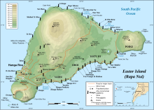
Topographic map of Easter Island using colors to show elevations.
In cartographic design, map coloring is the act of choosing colors as a form of map symbol to be used on a map.
Color is a very useful attribute to depict different features on a map.[1] Typical uses of color include displaying different political divisions, different elevations, or different kinds of roads. A choropleth map is a thematic map in which areas are colored differently to show the measurement of a statistical variable being displayed on the map. The choropleth map provides an easy way to visualize how a measurement varies across a geographic area or it shows the level of variability within a region. In addition to choropleth maps, a cartographer should strive to depict colors effectively on any kind of map.
Displaying the data in different hues can greatly affect the understanding or feel of the map.[2] In many cultures, certain colors have connotations. These connotations lie under a field of study called color symbolism. For example, coloring a certain nation a color that has a negative connotation in their culture could be counterproductive. Likewise, using assumed skin colors to show racial or ethnic patterns will likely cause offense. It is not possible to always predict the color connotations of every map reader or to avoid negative connotations, but it is helpful to be aware of common color connotations in order to make a map as appealing and understandable as possible.[3]
Cartographers may also choose to pick hues that are associated with what they are mapping. For example, when mapping precipitation, they may choose to use shades of blue or for a map of wildfires they may use yellows, reds, and oranges. Carefully choosing colors ensures that the map is intuitive and easy to read.[4] This process is referred to as feature association. Also, the cartographer must take into account that many people have impaired color vision, and colors must be used that are easily distinguishable by such readers.[5]
A general rule is that most people can differentiate only between 5-8 different shades of one color. Rather than more than 8 shades of a color, it is best to use multiple colors. Most GIS programs provide users with carefully curated color schemes to choose from, thus making the process of selecting colors easier.
Colors can also be used to produce three-dimensional effects from two-dimensional maps, either by explicit color-coding of the two images intended for different eyes, or by using the characteristics of the human visual system to make the map look three-dimensional.[6]
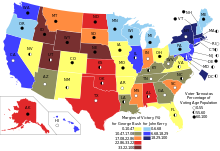
The 2004 United States presidential election visualised using a choropleth map
^Matt Rosenberg. "Map Colors - The Role of Colors on Maps".
^Robinson, A.H. (1967). "Psychological aspects of color in cartography". International Yearbook of Cartography. 7: 50–61.
^Tyner, Judith (2010). Principles of Map Design. Guilford Press. pp. 64–65.
^Lin, Sharon (2014). "The right colors makes data easier to read". Harvard Business Review.
^Brewer, C. (1996). "Guidelines for selecting colors for diverging schemes on maps". The Cartographic Journal. 33 (2). Maney Publishing: 79–86. Bibcode:1996CartJ..33...79B. doi:10.1179/caj.1996.33.2.79.
In cartographic design, mapcoloring is the act of choosing colors as a form of map symbol to be used on a map. Color is a very useful attribute to depict...
results about graph coloring deal almost exclusively with planar graphs in the form of mapcoloring. While trying to color a map of the counties of England...
the problem equivalent to coloring a map on a torus (a surface of genus 1), which requires up to 7 colors for an arbitrary map. A similar construction also...
job title is Colorist Graph coloring, in mathematics Hair coloring Food coloring Hand-colouring of photographs Mapcoloring Color code (disambiguation)...
to Java, starting with a concrete example. The goal of a mapcoloring problem is to color a map so that regions sharing a common border have different colors...
the maps theme and should stand out. NATO Joint Military Symbology Mapcoloring Krygier, J. & Wood, D. (2005). Making Maps: A Visual Guide to Map Design...
the study of graph coloring problems in mathematics and computer science, a greedy coloring or sequential coloring is a coloring of the vertices of a...
As an example, consider the well-known mapcoloring or Graph coloring problem. Here, we wish to color a map in such a way that no bordering countries...
constraint satisfaction problem include: Type inference Eight queens puzzle Mapcoloring problem Maximum cut problem Sudoku, crosswords, futoshiki, Kakuro (Cross...
the nose Snort (software), a package for intrusion detection Snort, a map-coloring game Insufflation, the act of blowing, breathing, hissing, or puffing...
edge coloring of a graph by the colors red, blue, and green. Edge colorings are one of several different types of graph coloring. The edge-coloring problem...
mathematically inspired) two-player games, such as nim, hackenbush, and the map-coloring games col and snort. The development includes their scoring, a review...
topology, such as topology-preserving shape simplification, automatic mapcoloring, and cartograms. A reference implementation of the TopoJSON specification...
In complex analysis, domain coloring or a color wheel graph is a technique for visualizing complex functions by assigning a color to each point of the...
graph coloring game is a mathematical game related to graph theory. Coloring game problems arose as game-theoretic versions of well-known graph coloring problems...
Web mapping Mapcoloring Geographic information systems Hogräfer, M., Heitzler, M. and Schulz, H.‐J. (2020), The State of the Art in Map‐Like Visualization...
by the topology defined by the probable errors and is related to the mapcoloring problem. Game theory: Models based on signaling games combine elements...
scheduling problem Problems in constraint satisfaction, such as: The mapcoloring problem Filling in a sudoku or crossword puzzle In game theory and especially...
and processes information from across the electromagnetic spectrum. Mapcoloring Pansharpening "Principles of Remote Sensing - Centre for Remote Imaging...
regions share a common border. The problem is then translated into a graph coloring problem: one has to paint the vertices of the graph so that no edge has...
enclosing the most volume within the same radius. It has 43,380 nets. The map-coloring number of a regular dodecahedron's faces is 4. The distance between the...
In graph theory, circular coloring is a kind of coloring that may be viewed as a refinement of the usual graph coloring. The circular chromatic number...
list), a list coloring is a choice function that maps every vertex v to a color in the list L(v). As with graph coloring, a list coloring is generally...
 Global Information