 Global Information
The Dalles Dam information
| The Dalles Lock and Dam | |
|---|---|
 From the Washington side | |
| Official name | The Dalles Lock and Dam |
| Location | Klickitat County, Washington / Wasco County, Oregon, USA |
| Coordinates | 45°36′49″N 121°08′00″W / 45.61361°N 121.13333°W |
| Construction began | 1952 |
| Opening date | 1957 |
| Operator(s) | U.S. Army Corps of Engineers (Operator) Bonneville Power Administration (Marketer) |
| Dam and spillways | |
| Type of dam | Concrete gravity, run-of-the-river |
| Height | 200 ft (61 m) |
| Length | 8,835 ft (2,693 m) |
| Width (base) | 239 ft (73 m) (Spillway) |
| Spillway type | Service, gate-controlled |
| Spillway capacity | 2,290,000 cu ft/s (65,000 m3/s) |
| Reservoir | |
| Creates | Lake Celilo |
| Total capacity | 330,000 acre⋅ft (0.41 km3) |
| Power Station | |
| Turbines | 22 |
| Installed capacity | 1,878.3 MW Max.: 2,160 MW |
| Annual generation | 6,180 GWh[1] |
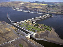
The Dalles Lock and Dam is a concrete-gravity run-of-the-river dam spanning the Columbia River, two miles (3 km) east of the city of The Dalles, Oregon, United States.[2] It joins Wasco County, Oregon with Klickitat County, Washington, 192 miles (309 km) upriver from the mouth of the Columbia near Astoria, Oregon. The closest towns on the Washington side are Dallesport and Wishram.
The U.S. Army Corps of Engineers (USACE) began work on the dam in 1952 and completed it five years later. Slack water created by the dam submerged Celilo Falls, the economic and cultural hub of Native Americans in the region and the oldest continuously inhabited settlement in North America.[3] Inhabitants of the submerged area include the Wasco–Wishram[4] and Skinpah.[5]
On March 10, 1957, hundreds of observers looked on as the rising waters rapidly silenced the falls, submerged fishing platforms, and consumed the village of Celilo. Ancient petroglyphs were also in the area being submerged. Approximately 40 petroglyph panels were removed with jackhammers before inundation and were placed in storage before being installed in Columbia Hills State Park in the 2000s.[6]
The reservoir behind the dam is named Lake Celilo and runs 24 miles (39 km) up the river channel, to the foot of John Day Dam. The dam is operated by the USACE, and the power is marketed by the Bonneville Power Administration (BPA). It is part of an extensive system of dams on the Columbia and Snake Rivers.
The Dalles Dam Visitor Center, in Seufert Park on the Oregon shore, was built in 1981. A tour train was closed in autumn 2001, partly due to post-September 11 security concerns, and partly due to deteriorating track conditions and a small derailment.[7] The Columbia Hills State Park is nearby.
The Dalles Dam is one of the ten largest hydroelectric dams in the United States. Along with hydro power, the dam provides irrigation water, flood mitigation, navigation, and recreation. The Dalles Lock and Dam has been designated as a National Historic Civil Engineering Landmark by the American Society of Civil Engineers.[8]
- ^ "Carbon Monitoring for Action | Center For Global Development". Archived from the original on 2014-03-18. Retrieved 2014-03-18.
- ^ "The Columbia River System Inside Story" (PDF). BPA.gov. pp. 14–15. Archived from the original (PDF) on 27 May 2010. Retrieved 17 July 2010.
- ^ Dietrich, William (1995). Northwest Passage: The Great Columbia River. Seattle, WA: University of Washington Press. p. 52.
- ^ "Celilo Falls, Oregon". National Park Service. May 10, 2023. Archived from the original on October 2, 2023. Retrieved September 24, 2023.
- ^ Hunn, Eugene S. (Winter 2007). "Sk'in, The Other Side of the River". Oregon Historical Quarterly. 108 (4): 614–623. doi:10.1353/ohq.2007.0028. S2CID 165209382.
- ^ Banyasz, Malin Grunberg (May–Jun 2017). "Off the Grid". Archaeology. 70 (3): 10. ISSN 0003-8113. Retrieved 3 July 2017 – via EBSCO's Master File Complete (subscription required)
{{cite journal}}: CS1 maint: postscript (link) - ^ "About". The Dalles Dam Tour Train. Archived from the original on 2016-04-07. Retrieved 2023-10-02.
- ^ Goodell, Christopher R. (Spring 2014). "The Dalles Dam – An ASCE National Historic Civil Engineering Landmark" (PDF). EWRI Currents. 17 (2): 6–9. Archived from the original on November 24, 2021. Retrieved November 24, 2021.