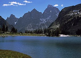
Lake Solitude and the northwest view of Grand Teton from the Teton Crest Trail
Length
40 mi (64 km)
Location
Teton Range
Trailheads
Phillips Pass, Wyoming String Lake, Grand Teton National Park, Wyoming
Use
Hiking
Elevation change
3,775 ft (1,151 m)
Highest point
Paintbrush Divide, 10,645 ft (3,245 m)
Lowest point
String Lake, 6,870 ft (2,090 m)
Difficulty
Strenuous
Season
Summer to Fall
Sights
Teton Range
Hazards
Severe weather Grizzly bears
The Teton Crest Trail is a 40-mile (64 km) long hiking trail in the U.S. state of Wyoming that extends from Phillips Pass, on the border of Bridger Teton and Caribou-Targhee National Forests, to String Lake in Grand Teton National Park.[1][2][3]Backpacker Magazine calls the Trail one of the "Best Hikes Ever," with "mesmerizing and constant views of jagged peaks."[4]
Beginning in the south, the Teton Crest Trail can be accessed in several ways. From inside the National Park, the Granite Canyon Trail provides a gradual ascent into the Range, where it connects with the TCT. The Trail is most easily accessed by riding the Jackson Hole Aerial Tram, which transports sightseers and hikers from the Teton Village Resort to the top of Rendezvous Mountain. From outside the Park, the Teton Crest Trail can be accessed via the Phillips Pass Trail,[5] one of several routes through adjacent National Forest lands.
Continuing from the south, it is a 32-mile (51 km) trek to String Lake, passing in and out of Bridger-Teton National Forest twice, traversing the Death Canyon Shelf and several high passes including Mount Meek Pass, Hurricane Pass and Paintbrush Divide. It is a challenge with 9,681 feet total ascent and 10,779 feet total descent. The trail also traverses the high alpine meadows of Alaska Basin in the Bridger-Teton National Forest. From Hurricane Pass, the trail provides easy access to Schoolroom Glacier, and parallels the west side of major peaks of the Cathedral Group as it follows the North and South forks of the Cascade Creek.[6]
^ ab"Teton Crest Trail". Geographic Names Information System. United States Geological Survey, United States Department of the Interior. Retrieved 2012-02-12.
about 2 miles (3.2 km) north of Teton Village and ends at the junction with the TetonCrestTrail near Marion Lake. The trail follows the length of Granite...
trail (also known as the Alaska Basin Shelf Trail) continuing north to junction with the TetonCrestTrail. There are no camping zones on the trail within...
the TetonCrestTrail. This trail is considered very strenuous. Amphitheater Lake Trail ascends from Lupine Meadows to Amphitheater Lake. The trail is...
state of Wyoming. The trail connects the Rendezvous Mountain Trail with the TetonCrestTrail. It is the route taken by those who use the Jackson Hole Mountain...
accessed by way of the TetonCrestTrail or the Death Canyon Trail from the east. To the north lies the Death Canyon Shelf in Grand Teton National Park while...
accessed from the south by way of the TetonCrestTrail or from the north via the South Fork Cascade Canyon Trail. From Jenny Lake the roundtrip hike is...
allowed with a permit. The South Fork Cascade Canyon Trail is also part of the TetonCrestTrail its entire length and to the south beyond Hurricane Pass...
is traversed by the TetonCrestTrail and can be accessed via trails from Teton Pass to the southwest or the Phillips Canyon Trail to the east. "Phillips...
Grand Teton is the highest mountain of the Teton Range in Grand Teton National Park at 13,775 feet (4,199 m) in Northwest Wyoming. Below its north face...
where it intercepts the TetonCrestTrail. The trail follows the length of Death Canyon. To get to the trail, the Valley Trail must be accessed at the...
9,718 ft (2,962 m) above sea level and is accessed by way of the TetonCrestTrail and is immediately east of Mount Meek. Mount Meek Pass is more than...
Grand Teton to the south. An ice axe may be necessary for hikes in the early summer. The Paintbrush Canyon Trail is part of the TetonCrestTrail, which...
on Death Canyon Shelf with a permit. The shelf is traversed by the TetonCrestTrail for its entire length, but it is deep in the backcountry, requiring...
northwest along Teton Creek through Teton Canyon. Access into the basin is by trail only and the basin is bisected by the TetonCrestTrail which connects...
Appalachian Trail and the Pacific CrestTrail inspired proposals to create a Continental Divide trail. The first section of the proposed trail was laid out...
Pass and into Jackson Hole, Wyoming. From there they went over the Teton Range via Teton Pass and then down to the Snake River into modern Idaho. They abandoned...
the Teton Range, Caribou-Targhee National Forest in the U.S. state of Wyoming. The peak is situated near the head of Death Canyon and the TetonCrest Trail...
in excess of 12,999 ft (3,962 m). With the exception of the Grand Teton in the Teton Range, the next 19 highest peaks in Wyoming after Gannett are also...
of his PCT Hikers Handbook, which described hiking the entire Pacific CrestTrail in a much shorter time, using homemade lightweight gear and techniques...
traverses the McGregor Plateau to the spine of the Rockies, following the crest of the Canadian Rockies southeast to the 120th meridian west, from there...
The trail then weaves northwest 83 miles (134 km) through the wilderness to Stony Pass on San Juan County Road 3 near Silverton. Following the crest of...
Mountains of Southeastern Utah, the Uinta Range of Utah and Wyoming, and the Teton Range of Wyoming and Idaho. The western edge of the Rockies includes ranges...
runs the length of Shenandoah. PCT Elevation Profiles – The Pacific CrestTrail goes through seven national parks. North Cascades – Washington section...
TTB Aerolíneas Turísticas del Caribe AERO TURISTICAS Mexico TTE Avcenter TETON United States TUN Air Tungaru TUNGARU Kiribati defunct EC TWN Avialeasing...
 Global Information