Urban planning restricting through traffic of automobiles
This article has multiple issues. Please help improve it or discuss these issues on the talk page. (Learn how and when to remove these template messages)
This article possibly contains original research. Several paragraphs contain unsourced information on a niche subject. Please improve it by verifying the claims made and adding inline citations. Statements consisting only of original research should be removed.(October 2023) (Learn how and when to remove this message)
This article needs additional citations for verification. Please help improve this article by adding citations to reliable sources. Unsourced material may be challenged and removed. Find sources: "Street hierarchy" – news · newspapers · books · scholar · JSTOR(July 2019) (Learn how and when to remove this message)
(Learn how and when to remove this message)
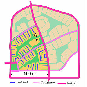
The network structure of Radburn, New Jersey exemplifies the concept of street hierarchy of contemporary districts. (The shaded area was not built.)
The street hierarchy is an urban planning technique for laying out road networks that exclude automobile through-traffic from developed areas. It is conceived as a hierarchy of roads that embeds the link importance of each road type in the network topology (the connectivity of the nodes to each other). Street hierarchy restricts or eliminates direct connections between certain types of links, for example residential streets and arterial roads, and allows connections between similar order streets (e.g. arterial to arterial) or between street types that are separated by one level in the hierarchy (e.g. arterial to highway and collector to arterial). By contrast, in many regular, traditional grid plans, as laid out, higher order roads (e.g. arterials) are connected by through streets of both lower order levels (e.g. local and collector). An ordering of roads and their classification can include several levels and finer distinctions as, for example, major and minor arterials or collectors.
At the lowest level of the hierarchy, cul-de-sac streets,[1] by definition non-connecting, link with the next order street, a primary or secondary "collector"—either a ring road that surrounds a neighbourhood, or a curvilinear "front-to-back" path—which in turn links with the arterial. Arterials then link with the intercity highways at strictly specified intervals at intersections that are either signalized or grade separated.
In places where grid networks were laid out in the pre-automotive 19th century, such as in the American Midwest, larger subdivisions have adopted a partial hierarchy, with two to five entrances off one or two main roads (arterials) thus limiting the links between them and, consequently, traffic through the neighbourhood.
Since the 1960s, street hierarchy has been the dominant network configuration of suburbs and exurbs in the United States, Canada, Australia, and the UK. It is less popular in Latin America, Western Europe, and China.
Large subdivisions may have three- or even four-tiered hierarchies, feeding into one or two wide arterials, which can be as wide as the ten lane Champs-Élysées or Wilshire Boulevard. Arterials at this level of traffic volume generally require no fewer than four lanes in width; and in large contemporary suburbs, such as Naperville, Illinois, or Irvine, California, are often eight or ten lanes wide. Adjacent street hierarchies are rarely connected to one another.
^[1] An Oregon Guide for Reducing Street Widths | Neighborhood Street Design Guidelines
The streethierarchy is an urban planning technique for laying out road networks that exclude automobile through-traffic from developed areas. It is conceived...
A settlement hierarchy is a way of arranging settlements into a hierarchy based upon their size. The term is used by landscape historians and in the National...
A hierarchy (from Greek: ἱεραρχία, hierarkhia, 'rule of a high priest', from hierarkhes, 'president of sacred rites') is an arrangement of items (objects...
road hierarchy categorizes roads according to their functions and capacities. While sources differ on the exact nomenclature, the basic hierarchy comprises...
transport hierarchy (Canada), street user hierarchy (US), sustainable transport hierarchy (Wales), urban transport hierarchy or road user hierarchy (Australia...
A street is a public thoroughfare in a built environment. It is a public parcel of land adjoining buildings in an urban context, on which people may freely...
speed limit, fully landscaped routes that form the top layer of the streethierarchy for both private and public transport in Milton Keynes, Buckinghamshire...
approaches, one with and the other without hierarchy or cul-de-sac streets. It concluded that the non-hierarchical, traditional layout generally shows lower...
matching the streethierarchy model described above. Street width, or right of way (ROW), influences the amount of land that is devoted to streets, which becomes...
intelligent urbanism Streethierarchy – Urban planning restricting through traffic of automobiles Street reclamation – Changing streets to focus on non-car...
Assured Clear Distance Ahead Hierarchy of roads Low emission zone Pedestrian Road traffic control Shared space Streethierarchy Sustainable transportation...
high-capacity urban road that sits below freeways/motorways on the road hierarchy in terms of traffic flow and speed. The primary function of an arterial...
engineering" in the entire world. Built as a utopian ideal city, its streethierarchy, layout and certain grandeur of buildings often resemble Paris or London...
Visual hierarchy, according to Gestalt psychology, is a pattern in the visual field wherein some elements tend to "stand out," or attract attention, more...
use by vehicles (motorized and non-motorized) and pedestrians. Unlike streets, whose primary function is to serve as public spaces, the main function...
material based on cobble-sized stones, and is used for pavement roads, streets, and buildings. Setts, also called Belgian blocks, are often inaccurately...
Main Street is a metonym used to denote a primary retail street of a village, town or small city in many parts of the world. It is usually a focal point...
Budapest Grand Boulevard, Budapest Hungária Boulevard, Budapest O'Connell Street, Dublin Viali di Circonvallazione, Florence Gran Via de les Corts Catalans [es]...
other tracks. Overpasses near Barcelona Cumberland Highway overpasses a street in Sydney A high-capacity stack interchange: the Judge Harry Pregerson Interchange...
any public street in the City for seventy-two or more consecutive hours." Other areas may prohibit leaving vehicles on residential streets during certain...
lane reversal 2+1 road Streethierarchy Tactical urbanism – Low-cost, temporary improvement to a city Transit mall – Urban street reserved for public transit...
street Primitive road Road Side road Single carriageway Single-track road Street Sunken lane Other terms Channelization Concurrency Detour Hierarchy of...
Cul-de-sac / Dead end (street) Drive Frontage road Gemeindestraße Highway Kreisstraße Lane Landesstraße Living street Loop One-way street Path Place Plaza Road...
clear ice, is a thin coating of glaze ice on a surface, especially on streets. The ice itself is not black, but visually transparent, allowing the often...
street Primitive road Road Side road Single carriageway Single-track road Street Sunken lane Other terms Channelization Concurrency Detour Hierarchy of...
street Primitive road Road Side road Single carriageway Single-track road Street Sunken lane Other terms Channelization Concurrency Detour Hierarchy of...
 Global Information