"Spratly" redirects here. For the surname, see Spratly (surname).
Spratly Islands
class=notpageimage|
Location of the Spratly Islands
Part of a series on the
Spratly Islands
Spratly Islands military occupations map
Related articles
Spratly Islands dispute
Territorial disputes in the South China Sea
Philippines and the Spratly Islands
Dangerous Ground (South China Sea)
Great Wall of Sand
History of the Spratly Islands
List of maritime features in the Spratly Islands
List of airports in the Spratly Islands
Vietnamese DK1 rigs
Royal Malaysian Navy Offshore Bases
Republic of Morac-Songhrati-Meads
Free Territory of Freedomland
Confrontations
Southwest Cay incident (1975)
East Sea Campaign (1975)
Johnson South Reef skirmish (1988)
Military occupations
Occupied by Brunei
Louisa Reef-Semarang Barat Kecil Reef
Occupied by China (PRC)
Cuarteron Reef, Huayang Reef
Fiery Cross Reef, Yongshu Reef
Gaven Reefs, Nanxun Reef and Xinan Reef
Hughes Reef, Dongmen Reef
Johnson South Reef, Chigua Reef
Mischief Reef, Meiji Reef
Subi Reef, Zhubi Reef
Occupied by Malaysia
Ardasier Reef, Ubi Reef
Dallas Reef, Laya Reef
Erica Reef, Siput Reef
Investigator Shoal, Peninjau Shoal
Mariveles Reef, Mantanani Reef
Swallow Reef, Layang-Layang Island
Occupied by the Philippines
Commodore Reef, Rizal Reef
Flat Island, Patag Island
Irving Reef, Balagtas Reef
Lankiam Cay, Panata Island
Loaita Cay, Melchora Aquino Island
Loaita Island, Kota Island
Nanshan Island, Lawak Island
Northeast Cay, Parola Island
Second Thomas Shoal, Ayungin Shoal
Thitu Island, Pagasa Island
West York Island, Likas Island
Occupied by Taiwan (ROC)
Centre Cay, Zhongzhou Reef
Itu Aba Island, Taiping Island
Occupied by Vietnam
Amboyna Cay, An Bang Island
Bombay Castle, Ba Ke
Collins Reef, Co Lin Reef
Cornwallis South Reef, Nui Le Reef
Ladd Reef, Lat Reef
Namyit Island, Nam Yet Island
Sand Cay, Son Ca Island
Sin Cowe Island, Sinh Ton Island
Southwest Cay, Song Tu Tay Island
Spratly Island, Truong Sa Island
Unoccupied
Half Moon Shoal
Luconia Shoals
Northeast Investigator Shoal
Royal Captain Shoal
Sabina Shoal
Western Reef
Whitsun Reef
v
t
e
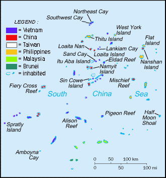
The Spratly Islands (Filipino: Kapuluan ng Kalayaan;[1] Mandarin Chinese: 南沙群島/南沙群岛; pinyin: Nánshā Qúndǎo; Malay: Kepulauan Spratly; Vietnamese: Quần đảo Trường Sa) are a disputed archipelago in the South China Sea. Composed of islands, islets, cays,[2] and more than 100 reefs, sometimes grouped in submerged old atolls,[3] the archipelago lies off the coasts of the Philippines, Malaysia, and southern Vietnam. Named after the 19th-century British whaling captain Richard Spratly who sighted Spratly Island in 1843, the islands contain less than 2 km2 (490 acres) of naturally occurring land area, which is spread over an area of more than 425,000 km2 (164,000 sq mi).
The Spratly Islands are one of the major archipelagos in the South China Sea which complicate governance and economics in this part of Southeast Asia due to their location in strategic shipping lanes. The islands are largely uninhabited, but offer rich fishing grounds and may contain significant oil and natural gas reserves,[4][5][6] and as such are important to the claimants in their attempts to establish international boundaries. Some of the islands have civilian settlements, but of the approximately 45 islands, cays, reefs and shoals that are occupied, all contain structures that are occupied by military forces from Malaysia, China (PRC), Taiwan (ROC), the Philippines, and Vietnam. Additionally, Brunei has claimed an exclusive economic zone in the southeastern part of the Spratly Islands, which includes the uninhabited Louisa Reef.
^Anda, Redempto (17 July 2012). "Government told of China buildup 2 months ago". Philippine Inquirer. Archived from the original on 2 November 2013. Retrieved 29 October 2013.
^Claudius Madrolle (1939). "La question de Hai-nan et des Paracels" [The question of Hai-nan and Paracel]. Politique étrangère (in French). 4 (3): 302–312. doi:10.3406/polit.1939.5631. Archived from the original on 5 June 2018. Retrieved 7 May 2016.
^Cite error: The named reference ECO was invoked but never defined (see the help page).
^Owen, N. A. and C. H. Schofield, 2012, Disputed South China Sea hydrocarbons in perspective. Marine Policy. vol. 36, no. 3, pp. 809–822.
^"Why is the South China Sea contentious?". BBC. 12 July 2016.
^"Q&A: South China Sea dispute". BBC News. 13 June 2011. Archived from the original on 17 October 2013. Retrieved 30 October 2013.
the 19th-century British whaling captain Richard Spratly who sighted SpratlyIsland in 1843, the islands contain less than 2 km2 (490 acres) of naturally...
Philippines, Taiwan, and Vietnam concerning "ownership" of the SpratlyIslands, a group of islands and associated "maritime features" (reefs, banks, and cays...
Vietnamese-administered Spratlyislands. In 2016 the Vietnamese embarked on a land reclamation program at ten locations in the SpratlyIslands. At SpratlyIsland 37 acres...
Description of the SpratlyIslands and an Account of Hydrographic Surveys Amongst Those Islands, IBRU, 1995 "What does disputed Paracel island look like?"....
within the SpratlyIslands: Vietnam occupies and/or controls six islands, seventeen reefs and three banks, ROC occupies and/or controls one island and one...
Union Banks region of the SpratlyIslands, in the South China Sea. The SpratlyIslands are a group of over 100 small islands, reefs and atolls located...
Island, also known as Itu Aba, and various other names, is the largest of the naturally occurring SpratlyIslands in the South China Sea. The island is...
Paracel Islands (1974). Pratas Island and the Vereker Banks, disputed between the PRC and the ROC, occupied by the ROC. The SpratlyIslands, disputed...
of lists of maritime features in the SpratlyIslands. Of the hundreds of maritime features in the SpratlyIslands, relatively few have land permanently...
Islands in the South China Sea includes the South China Sea Islands (SpratlyIslands, Pratas Island, Paracel Islands and Macclesfield Bank), islands on...
which include the SpratlyIslands, portions of North Borneo, and the Scarborough Shoal. The Philippine government claims SpratlyIslands features locating...
over Spratly and Paracel Islands. Presently, the Paracel Islands are disputed among China (PRC), Taiwan (ROC), and Vietnam, while Pratas Island is contested...
The disputes involve the islands, reefs, banks, and other features of the region, including the SpratlyIslands, Paracel Islands, Scarborough Shoal, and...
are: The SpratlyIslands The Paracel Islands Pratas Island and the Vereker Banks The Macclesfield Bank The Scarborough Shoal The SpratlyIslands spread...
Ground in the east of the SpratlyIslands in the South China Sea. It is located 250 kilometres (130 nmi) west of Palawan Island of the Philippines. Administratively...
government deliberately had her run aground on Second Thomas Shoal in the SpratlyIslands to serve as an outpost of the Philippine Marine Corps to assert Philippine...
airports in the SpratlyIslands in the South China Sea. Taiping Layang-Layang Yongshu Rancudo Trường Sa Zhubi Meiji The Taiping Island Airport was completed...
group of 260 islands, reefs and beaches located in the SpratlyIslands (Nansha), Paracel Islands (Xisha), and Macclesfield Bank (Zhongsha Islands). Reports...
largest island country. The eleven largest islands contain 95% of the total land area. The largest of these islands is Luzon at about 105,000 square kilometers...
鴻庥島/鸿庥岛; pinyin: Hóngxiū Dǎo, is the third-largest island on Tizard Bank in the northwest of the SpratlyIslands in South China Sea. With an area of 5.3 hectares...
islands, Taiwan and the various affiliated islands including Diaoyu Island, Penghu Islands, Dongsha Islands, Xisha Islands, Nansha (Spratly) Islands and...
well as the SpratlyIslands and the Paracel Islands." The Philippines bases its claim on its geographical proximity to the SpratlyIslands. In May 1956...
(Vietnamese) and Rén'ài Jiāo (Chinese: 仁爱礁/仁愛礁), is a submerged reef in the SpratlyIslands of the South China Sea, 105 nautical miles (194 km; 121 mi) west of...
 Global Information