This article includes a list of general references, but it lacks sufficient corresponding inline citations. Please help to improve this article by introducing more precise citations.(January 2014) (Learn how and when to remove this message)
Southwestern Tablelands
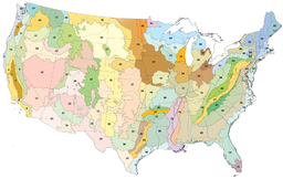
Central Great Plains (area 26 on the map)
Ecology
Realm
Nearctic
Borders
List
Western High Plains to the north and south of the Southwestern Tablelands corridor
Central Great Plains to the east
Southern Rockies to the northwest
Arizona/New Mexico Plateau a very small portion to the central west
Arizona/New Mexico Mountains and Chihuahuan Desert to the south-southwest
Edwards Plateau to the southeast
Central Great Plains to the east
Bird species
[1]
Mammal species
[1]
Geography
Country
United States
State
Colorado, Kansas, New Mexico, Oklahoma, Texas
Climate type
Cold semi-arid
The southwestern tablelands comprise an ecoregion running from east-central to south-east Colorado, east-central and a small portion of eastern New Mexico, some eastern portions of the Oklahoma Panhandle, far south-central Kansas, and portions of northwest Texas. This ecoregion has a "cold semiarid" climate (Köppen BSk). Some years, a National Weather Service dust storm warning is issued in parts of Texas due to a dust storm originating from the lower part of the Southwestern Tablelands ecological region or from the southern end of the Western High Plains ecological region.[2]
^ abcd
Hoekstra, J. M.; Molnar, J. L.; Jennings, M.; Revenga, C.; Spalding, M. D.; Boucher, T. M.; Robertson, J. C.; Heibel, T. J.; Ellison, K. (2010). Molnar, J. L. (ed.). The Atlas of Global Conservation: Changes, Challenges, and Opportunities to Make a Difference. University of California Press. ISBN 978-0-520-26256-0.
^Dust storm#Dust storm visibility of 1.2F4 mile or less.2C or meters or less
and 11 Related for: Southwestern Tablelands information
The southwesterntablelands comprise an ecoregion running from east-central to south-east Colorado, east-central and a small portion of eastern New Mexico...
Tablelands or tableland may refer to: Chaplains Tableland Central Tablelands Northern Tablelands Southern Tablelands Barkly TablelandTablelands Highway...
Llano Estacado and the western portion of the lower part of the SouthwesternTablelands ecological region. South Plains extends south of the Texas Panhandle...
below that layer Ordovician dolomites. The Boston Mountains form the southwestern part of the Ozark plateau where they are the highest portion of the Ozarks...
Arizona/New Mexico Mountains Great Plains 25 Western High Plains 26 SouthwesternTablelands 27 Central Great Plains 28 Flint Hills 29 Central Oklahoma/Texas...
addition, there exists a Barkly Tablelands IBRA subregion which conforms approximately with parts of the Barkly Tablelands proper. Maps of different circumscriptions...
town of Ardmore. An extension in two branches of the Cross Timbers into southwestern Oklahoma, this area features reduced tree density and height, but also...
complex of small mountain ranges in southern and southeastern Arizona, southwestern New Mexico, and northwestern Mexico. The sky islands are surrounded at...
Arizona/New Mexico Mountains Great Plains 25 Western High Plains 26 SouthwesternTablelands 27 Central Great Plains 28 Flint Hills 29 Central Oklahoma/Texas...
Desert vegetative sites. These areas are instead classified as SouthwesternTablelands. Grassland is the predominant landcover on Otero Mesa. These semi-arid...
Arizona/New Mexico Mountains Great Plains 25 Western High Plains 26 SouthwesternTablelands 27 Central Great Plains 28 Flint Hills 29 Central Oklahoma/Texas...
 Global Information