For the local government area in the Northern Territory, see Barkly Region.
Region in the Northern Territory, Australia
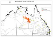
Barkly Tableland Northern Territory
Mitchell grass plains representing the Barkly Tableland proper
Population
6,330 (2007)[1]
• Density
0.0198/km2 (0.0512/sq mi)
Area
320,000 km2 (123,552.7 sq mi)
Territory electorate(s)
Barkly
Federal division(s)
Lingiari
Localities around Barkly Tableland:
Katherine Region
Gulf Country
Gulf Country
The Tanami
Barkly Tableland
Mount Isa Inlier
The Sandover
Channel Country
Mitchell Grass Downs
The Barkly Tableland is a region in the Central East if the Northern Territory, extending into Western Queensland. The region was named after Sir Henry Barkly. The epithet “Tableland” is inaccurate, since the region is neither elevated relative to adjacent landforms, nor are the boundaries marked by a distinct change in elevation [2][3]
The Barkly Tableland is a poorly defined region. The name Barkly Tableland properly applies only to the areas of largely treeless, cracking-clay soils supporting grasslands dominated by Mitchell Grass (Astrebla spp.) [4][5]
A variety of terms such as “Barkly Tablelands Region, or “Barkly Region” have come into common use, referring to various circumscriptions of the region. All include portions of the Barkly Tablelands proper, along with varying adjoining landforms and vegetation types.
Varying Barkly regions encompass:
An area from Dunmarra south to Barrow Creek, and from the Tanami desert to the Queensland border.[6][7]
The Barkly Tableland proper, the associated Gulf Country, the upper Georgina River basin, and portions of the inland desert country.[8]
From the McArthur River in the north, parallel approximately 100 miles inland from the west coast of the Gulf of Carpentaria to the Queensland border in the east.[9]
The Barkly Shire local government area[10]
Barkly locality in Queensland.
Various regions defined by Northern Territory and Australian Commonwealth government departments.[11][12][13][14][15]
In addition, there exists a Barkly Tablelands IBRA subregion which conforms approximately with parts of the Barkly Tablelands proper.[16]
Treeless Mitchell Grass Downs of the Barkly Tableland.
^Australian Bureau of Statistics (2 October 2008). "Australian Demographic Statistics" (PDF). Archived (PDF) from the original on 7 February 2009. Retrieved 24 June 2008.
^F. W. WHITEHOUSE (1940) “Studies in the Late Geological History of Queensland 3. 'THE EVOLUTION OF THE BARKLY TABLELAND”. UNIVERSITY OF QUEENSLAND DEPARTMENT OF GEOLOGY Series 2:1
^C.J. Edgoose & K.T. Winstanley. (2014) “LANDSCAPE EVOLUTION ON THE BARKLY TABLELAND” PROCEEDINGS OF THE AUSTRALIAN RANGELAND SOCIETY BIENNIAL CONFERENCE
^C.J. Edgoose & K.T. Winstanley. (2014) “LANDSCAPE EVOLUTION ON THE BARKLY TABLELAND” PROCEEDINGS OF THE AUSTRALIAN RANGELAND SOCIETY BIENNIAL CONFERENCE
^Jenny Purdie, Chris Materne, Andrew Bubb (2008) “A field guide to the plants of the Barkly Region, Northern Territory”)
^Jenny Purdie, Chris Materne, Andrew Bubb (2008) “A field guide to the plants of the Barkly Region, Northern Territory”)
^Collier, C. 2014. The 2010 Pastoral Industry Survey - Barkly Region. Northern Territory Government, Australia.
^C. S. CHRISTIAN (1954) PART I. “INTRODUCTION TO SURVEY OF THE BARKLY REGION” in “Survey of the Barkly Region, Northern Territory and Queensland, 1947-48 Land Research Series No. 3”. CSIRO)
^Warren M. Elofson SO FAR AND YET SO CLOSE: FRONTIER CATTLE RANCHING IN WESTERN PRAIRIE CANADA AND THE NORTHERN TERRITORY OF AUSTRALIA. University of Calgary Press
^Tollner, David William (18 December 2013). "Local Government Act changes to local government areas and councils" (PDF). Northern Territory Government Gazette. Northern Territory Government. p. 3. Retrieved 26 April 2019. with effect from 1 January 2014:
^PHN Northern Territory (2020) Barkly Region DATA REPORT. Northern Territory Government
^Department of the Chief Minister and Cabinet (2023) Barkly, retrieved October 2023
^Caroline Pettit (2013) Barkly District Land Condition Guide. Northern Territory Government”
^Pastoral Land Board (2022) “ANNUAL REPORT 2022” Northern Territory Pastoral Land Board
^Australian Government Department of Agriculture, Water and the Environment (2012) Interim Biogeographic Regionalisation for Australia, Version 7. Commonwealth of Australia
include portions of the BarklyTablelands proper, along with varying adjoining landforms and vegetation types. Varying Barkly regions encompass: An area...
nearby watercourse of the same name, and is the hub of the sprawling BarklyTableland – vast elevated plains of black soil with golden Mitchell grass, that...
August 1919 the spelling was changed and it became known as Shire of BarklyTableland. As a consequence of the growth of Mount Isa as a mining and population...
is named after the BarklyTableland, which is turn was named by explorer William Landsborough on December 1861 after Henry Barkly, the then Governor of...
Tablelands or tableland may refer to: Chaplains Tableland Central Tablelands Northern Tablelands Southern TablelandsBarklyTablelandTablelands Highway...
Mirndi, are a branch of the Mirndi languages spoken around in the BarklyTableland of Northern Territory, Australia. The branch consists of two to four...
The BarklyTableland death adder (Acanthophis hawkei) is a species of venomous snake in the family Elapidae. The exact distribution of the species is unclear...
Campbell was born in Atherton Tableland Queensland portal BarklyTableland Regions of Queensland Tablelands Region "Tablelands 2021 Census All persons QuickStats"...
Barkly may refer to : BarklyTableland, a region in the Northern Territory Barkly Highway, a national highway of both Queensland and Northern Territory...
created in 1974, and is named after the BarklyTableland area, which occupies much of the electorate. Barkly is a rural electorate, covering 442,868 km2...
is a Non-Pama-Nyungan West Barkly Australian language of the Mirndi language group that is spoken in the BarklyTableland of the Northern Territory, Australia...
The Barkly Region, formerly Barkly Shire, is a local government area of the Northern Territory of Australia, administered by the Barkly Regional Council...
Sunraysia in Victoria and Spencer Gulf in South Australia to the BarklyTableland in Northern Territory and the Kimberley region in Western Australia...
Avon Downs is a pastoral station on the BarklyTableland in the Northern Territory of Australia. It is located 260 kilometres northwest of Mount Isa. Indigenous...
by the members for Barkly, Katherine and Stuart. The Barkly local government region is roughly coterminous with the BarklyTableland and the "Tennant Creek...
station occupies an area of 6,955 square kilometres (2,685 sq mi) on the BarklyTableland. The Playford River runs through the property, which encompasses a...
Barkly Homestead is a roadhouse in the Northern Territory of Australia located on the BarklyTableland. It is located near the intersection of the Barkly...
Kimberley death adder Australia A. hawkei Wells & Wellington, 1985 0 BarklyTableland death adder Australia A. laevis Macleay, 1878 0 Smooth-scaled death...
during droughts, cattle carcasses provide most of the diet. On the BarklyTableland, no rabbits occur nor does any native species dominate the diet, except...
throughout Northern Australia southwards to the Great Sandy Desert, BarklyTableland, and the Gulf of Carpentaria in Queensland. P. s. brachypterus is found...
Sydney See also the Bureau of Meteorology's NT region map Arnhem Land BarklyTableland Central Australia/Alice Springs Region/Red Centre Darwin Region Katherine...
Warumungu dialect. The Kunapa's traditional lands lie on the Western BarklyTablelands of Central Australia, and include territory in the areas of the Banka...
other variants, are an Aboriginal Australian people of the southern BarklyTableland of the Northern Territory. Their language is the Wambaya language....
grass downs, coolabah woodland and spinifex desert situated on the BarklyTableland. The station has a carrying capacity of 50,000 head of Brahman cattle...
main regional centres of Alice Springs and Tennant Creek, the sparse BarklyTableland, and north to the Robinson River and Borroloola. The regiment is now...
Yorke Peninsula in South Australia. Disjunct populations occur on the BarklyTableland and the MacDonnell Ranges in the Northern Territory. and the far east...
Australia in the locality of Creswell on the western fringe of the BarklyTableland. The size of the lake fluctuates as a function of the amount of precipitation...
 Global Information