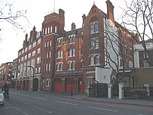
View of Southwark Bridge Road.Fire station on Southwark Bridge Road.251 Southwark Bridge Road from Elephant and Castle
Southwark Bridge Road is a road in Southwark, London, England,[1] between Newington Causeway near Elephant and Castle and Southwark Bridge across the River Thames, leading to the City of London, in a meandering route.
The road was created by connecting a series of other streets to provide access from the south to Southwark Bridge in 1819, which as a private venture was not able to use the publicly financed road system which had been created to improve access from the south to the City and the Westminster areas by the building of Westminster Bridge and Blackfriars Bridge in the late 18th Century which junction of routes combine at St George's Circus. This connection did not come about until the creation of Southwark Street in the 1880s. It does not start at the main northern roads junction at Elephant and Castle either.
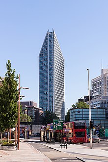
At the southern end is the campus of London South Bank University. The Ministry of Sound, a well-known nightclub, is in Gaunt Street, just to the east, and is faced with Two Fifty One, a new mixed-used high-rise building, the construction of which generated issues for the club.[2]
The London Fire Brigade Museum and the London Fire Brigade Training Centre were located on the road before the site started to be redeveloped in 2015.
At the northern end, across Southwark Street near the river are the Rose Theatre Exhibition, the Financial Times headquarters and Anchor Terrace, a Georgian building standing on the site of Shakespeare's original Globe Theatre.
The road is designated the A300.[3]
^"Southwark Bridge Road". london-se1.co.uk. UK. Retrieved 14 January 2015.
^"Ministry of Sound tower block plans approved by mayor". BBC News. UK. 7 January 2014. Retrieved 17 June 2021.
SouthwarkBridgeRoad is a road in Southwark, London, England, between Newington Causeway near Elephant and Castle and SouthwarkBridge across the River...
SouthwarkBridge (/ˈsʌðərk/ SUDH-ərk) is an arch bridge in London, for traffic linking the district of Southwark and the City across the River Thames....
The London Borough of Southwark (/ˈsʌðərk/ SUDH-ərk) in South London forms part of Inner London and is connected by bridges across the River Thames to...
first bridge. London's historic core, the City of London, lay north of the bridge and for centuries the area of Southwark just south of the bridge was partially...
The name "London Bridge" refers to several historic crossings that have spanned the River Thames between the City of London and Southwark, in central London...
Blackfriars Bridge is a road and foot traffic bridge over the River Thames in London, between Waterloo Bridge and Blackfriars Railway Bridge, carrying the...
historic Southwark, which is served by Borough and London Bridge stations. Its entrance is across the road from the disused Blackfriars Road railway station...
roads in zone 3 in Great Britain starting west of the A3 and south of the A4 (roads beginning with 3). Wikimedia Commons has media related to A roads...
the Southwark area of London. It runs from the north at Southwark Street to Borough High Street, crossing Union Street and SouthwarkBridgeRoad on the...
Tooley Street is a road in central and south London connecting London Bridge to St Saviour's Dock; it runs past Tower Bridge on the Southwark/Bermondsey side...
a street south of Marshalsea Road in Southwark, south London, England. At the northwest end is the SouthwarkBridgeRoad and at the southeast end is Borough...
of the planning and road improvements associated with the completion of Westminster Bridge in 1750, to provide access to Southwark from the north-west...
south bank of the River Thames close to London Bridge. It is the mother church of the Diocese of Southwark. It has been a place of Christian worship for...
Market is located on Southwark Street and Borough High Street just south of Southwark Cathedral on the southern end of London Bridge. The retail market...
Blackfriars Road is a road in Southwark, SE1. It runs between St George's Circus at the southern end and Blackfriars Bridge over the River Thames at the...
Westminster BridgeRoad is a road in London, England. It runs on an east–west axis and passes through the boroughs of Lambeth and Southwark. Between 1740...
the London Borough of Southwark, England, 2.5 miles (4.0 km) southeast of Charing Cross. To the west of Bermondsey lies Southwark, to the east Rotherhithe...
4), to Blackfriars Road, which further connects with Cycleway 6 on Blackfriars Road and Cycle Superhighway 7 on SouthwarkBridgeRoad. The section will...
at the turn of the 20th century. Its first headquarters were on SouthwarkBridgeRoad, before moving to Bankside in the early 20th century. The company...
 Global Information