This article includes a list of general references, but it lacks sufficient corresponding inline citations. Please help to improve this article by introducing more precise citations.(January 2016) (Learn how and when to remove this message)
Southern Nantahala Wilderness
IUCN category Ib (wilderness area)
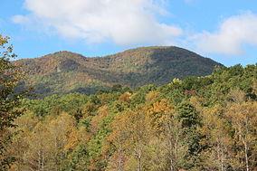
Hightower Bald
Map of the United States
Location
Clay and Macon, North Carolina and Rabun County, Georgia, USA
Nearest city
Tate City, Georgia
Area
23,473 acres (95 km2)
Designation
1984
Designated
Wilderness Area
Governing body
United States Forest Service
The Southern Nantahala Wilderness was designated in 1984 and currently consists of 23,473 acres (94.99 km2). Approximately 11,770 acres (47.6 km2) are located in Georgia in the Chattahoochee National Forest and approximately 11,703 acres (47.36 km2) are located in North Carolina in the Nantahala National Forest. The Wilderness is managed by the United States Forest Service and is part of the National Wilderness Preservation System. The highest elevation in the Southern Nantahala Wilderness is the 5,499-foot (1,676 m) peak of Standing Indian Mountain in North Carolina and the lowest elevation is approximately 2,400 feet (730 m). The Appalachian Trail passes through the Wilderness in both states.
In Georgia, the wilderness is divided into two sections by a corridor on either side of the Tallulah River. The western part of the Wilderness in Georgia includes the portion of the Appalachian Trail that begins at Blue Ridge Gap and climbs over Rocky Knob in Towns County before passing over the eastern flank of Rich Knob in Rabun County and entering North Carolina at Bly Gap. The eastern part of the Wilderness in Georgia includes an area on Coleman River.
In connection with its management of the Wilderness, the Forest Service actively promotes adherence to the Leave No Trace principles.
The wilderness was closed during the 2016 Rock Mountain fire.[1]
^Closure Order for the Southern Nantahala Wilderness. nwcg.gov. 16 November 2016. Retrieved 1 December 2016.
and 24 Related for: Southern Nantahala Wilderness information
The SouthernNantahalaWilderness was designated in 1984 and currently consists of 23,473 acres (94.99 km2). Approximately 11,770 acres (47.6 km2) are...
near the border of Georgia and North Carolina, close to the SouthernNantahalaWilderness and the Appalachian Trail. It flows into the Little Tennessee...
States The SouthernNantahalaWilderness, a federally preserved wilderness area in Georgia and North Carolina in the United States USS Nantahala, the name...
The SouthernNantahalaWilderness includes 10,900 acres (17.0 sq. mi.; 44.1 km2) in the North Carolina portion and lies in the Tusquitee and Nantahala Ranger...
County, North Carolina, near Standing Indian Mountain in the SouthernNantahalaWilderness and flows south into Georgia, crossing the state line into Towns...
part of the North Carolina portion of the SouthernNantahalaWilderness within the boundaries of the Nantahala National Forest. The mountain lies along...
construction of ships. In the early 20th century, much of what was considered wilderness was developed into golf courses. A short winding road leads to a parking...
protected by the Okefenokee National Wildlife Refuge and the Okefenokee Wilderness. The Okefenokee Swamp is considered to be one of the Seven Natural Wonders...
point is Buddy Cove Gap, with an elevation of 3164 feet near the Cohutta Wilderness. Its lowest point above sea level is close to Weogufka Creek near Weogufka...
Retrieved June 21, 2011. Wood, Amy Louise (2011). The New Encyclopedia of Southern Culture: Volume 19: Violence. Univ of North Carolina Press. ISBN 978-0807869284...
2017, storm surge from Hurricane Irma caused a tidal inlet to breach the southern end of Blackbeard Island, and it created a small island between Sapelo...
it were designated wilderness. In June 2017 during a land management plan revision, the Nantahala Ranger District on the Nantahala National Forest added...
tributary) Mocassin Run Nahunta Swamp Nantahala Lake Nantahala River Nantahala National Forest SouthernNantahalaWilderness Nolichucky River Nottely River North...
Rock Wilderness which straddles three states (Georgia, North Carolina and South Carolina) and three National Forests (the Chattahoochee, Nantahala and...
the SouthernNantahalaWilderness of the Chattahoochee National Forest. Hightower Bald is located on an east-west trending ridge inside the Southern Nantahala...
the former Atlanta mayor and United Nations ambassador, runs through the southern portion of the park. Since 2008, the area around the park has been marketed...
stretches for approximately 4 miles (6.4 km) from its northern tip to its southern tip and for roughly 2 miles (3.2 km) from its eastern shore to its western...
the initial occupation, but as the war dragged on, it became clear that Southern forces would not be able to retake the fort. The garrison was later reduced...
allowed in the seashore. The 9,886-acre (40.01 km2) Cumberland Island Wilderness is part of the seashore. The national seashore was authorized by Congress...
large wooded areas. More than 120 wildflowers, most of them native to the Southern Appalachians and including several rare or federally protected species...
winds past Amicalola Falls and leads to Springer Mountain, famous as the southern terminus of the Appalachian Trail, begins in the park. Amicalola Falls...
Gullies Mean: Georgia's 'Little Grand Canyon' and Southern Environmental History". Journal of Southern History. Vol. 76, no. 3. p. 579. Retrieved February...
 Global Information