612.33 cu ft/s (17.339 m3/s) at mouth with Little Tennessee River[4]
Basin features
Progression
generally north
River system
Little Tennessee River
Tributaries
• left
Indian Creek, Nichols Branch, Little Indian Creek, Kimsey Creek, Park Creek, Black Creek, Nova Scotia Branch, Buck Creek, Tate Branch, Tipton Branch, Clear Creek, Johnson Branch, Choga Creek, Lambert Cove, Dicks Creek, Appletree Branch, Walnut Cove, Poplar Cove, Pierce Creek, Rowlin Creek, Ledbetter Creek, Mudcut Branch, Mountain Branch, Morris Branch, Tomahawk Branch, Watia Creek, Jake Branch, Pump Branch, Turkey Branch
• right
Mooney Creek, Bearpen Creek, Thomas Branch, Hurricane Creek, Curtis Creek, Long Branch, Laurel Branch, Little Rock Branch, Trough Branch, Morris Branch, Bryson Branch, Factory Branch, Roaring Fork, Tyler Branch, Jarrett Creek, Rocky Branch, Wine Spring Creek, Rowland Branch, Beech Cove Branch, White Oak Creek, Camp Branch, Queens Creek, Silvermine Creek, Wesser Creek, Bird Falls Branch, Buckner Branch, Euchiella Branch, Siles Branch
Waterbodies
Nantahala Lake, Fontana Lake
Bridges
Standing Indian Loop, US 64, Thunderstruck Lane, Swinging Bridge Lane, Nantahala Dam Road, Junaluska Road, Wayah Road (x8), US 74, Pardon Bridge Road, Old Storehouse Road, NC 28
Playboater on the Nantahala RiverMist in Nantahala Gorge, where cold water is released from the dam
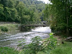
The Nantahala River (/ˌnæntəˈheɪlə/)[5] is a river in western North Carolina in the United States, within the Nantahala National Forest, and near the Great Smoky Mountains National Park. Two-lane U.S. Highway 19/74 runs along the river, picnic areas dotting the route. In 1839, this was an unimproved large path, part of what became known as the Trail of Tears as the Cherokee people were forcibly removed from their homelands in this region to west of the Mississippi River and Indian Territory.
The river rises near the border of Georgia and North Carolina, close to the Southern Nantahala Wilderness and the Appalachian Trail. It flows into the Little Tennessee River at Fontana Lake, a reservoir formed behind Fontana Dam.
The word Nantahala is Cherokee and means "Land of the Noonday Sun".[6] The river runs through a narrow and steep gorge where in some areas the sun reaches the ground only when it is directly overhead during the middle of the day. During the colonial era, Cherokee towns along the Nantahala, upper Hiwassee River, and Valley River in what is now North Carolina were known as the Valley Towns.
^ ab"GNIS Detail - Nantahala River". geonames.usgs.gov. US Geological Survey. Retrieved 17 October 2019.
^ ab"Nantahala River Topo Map, Swain County NC (Noland Creek Area)". TopoZone. Locality, LLC. Retrieved 17 October 2019.
^"ArcGIS Web Application". epa.maps.arcgis.com. US EPA. Retrieved 17 October 2019.
^ ab"Nantahala River Watershed Report". Waters Geoviewer. US EPA. Retrieved 17 October 2019.
^Talk Like A Tarheel Archived 2013-06-22 at the Wayback Machine, from the North Carolina Collection's website at the University of North Carolina at Chapel Hill. Retrieved 2013-02-05.
^Mohlenbrock, Robert H. (14 May 2014). This Land. University of California Press. p. 223. ISBN 978-0-520-93055-1.
The NantahalaRiver (/ˌnæntəˈheɪlə/) is a river in western North Carolina in the United States, within the Nantahala National Forest, and near the Great...
years. The NantahalaRiver runs through it. Colonists from South Carolina established a trade of deer hides with Cherokees from the Nantahala region, their...
Nantahala may refer to: Nantahala Lake, a lake in Macon County, North Carolina, in the United States The Nantahala National Forest, a national forest in...
River (Tennessee, Virginia) Little Tennessee River (Tennessee, North Carolina) Tellico River (Tennessee) Tuckasegee River (North Carolina) Nantahala River...
company on the Chattooga River, Southeastern Expeditions. Payson Kennedy, the stunt double for Ned Beatty, established the Nantahala Outdoor Center with his...
Mountains on the NantahalaRiver. Nantahala National Forest surround the service. The Appalachian Trail crosses the NantahalaRiver on a bridge next to...
Little Tennessee River. She is said to have also walked throughout the mountain range, around streams, and through shadowy NantahalaRiver passes. The Cherokee...
1988, Nantahala Power & Light Co., which served southwestern North Carolina, was purchased by Duke and is now operated under the Duke Power Nantahala Area...
River Meherrin River Moccasin Creek Moccasin Creek (Contentnea Creek tributary) Mocassin Run Nahunta Swamp Nantahala Lake NantahalaRiverNantahala National...
by Nantahala Outdoor Center at the NantahalaRiver Gorge and the NantahalaRiver crossing. Up to this point, the trail is maintained by the Nantahala Hiking...
NantahalaRiver is supplied with its water by Nantahala Lake. Water is released from the Nantahala Dam to create the [whitewater rapids] in the river...
Cullasaja River at Franklin. The river turns northwest, flowing through the Nantahala National Forest along the north side of the Nantahala Mountains...
River Cheoah River Tuckasegee River Oconaluftee RiverNantahalaRiver Cullasaja River French Broad River Nolichucky River Cane River North Toe River South...
lies along the Appalachian Trail and is the highest point along the NantahalaRiver. The Cherokee name for Standing Indian Mountain is Yunwitsule-nunyi...
former territory. They were later joined by Utsala's band from the NantahalaRiver in western North Carolina, and those few from the Valley Towns who...
people, who lived along the NantahalaRiver and were led by Utsala. Other groups living in Snowbird and along the Cheoah River (in Tomotley) also stayed...
as part of the Nantahala National Forest. The U.S. Forest Service has designated this as a National Scenic Byway because of the river and its numerous...
of the Nantahala National Forest. Depending on water levels, the lake is about 17 miles (27 km) long. The eastern end is the Tuckasegee River near Bryson...
the Tuckasegee River (which flows southward from Cherokee and Bryson City), and the lower 5 miles (8.0 km) or so of the NantahalaRiver, extending into...
Retrieved October 19, 2012. "Deschutes & Ochoco National Forests & Crooked River National Grassland". U.S. Forest Service. Retrieved October 19, 2012. "Dixie...
of about 150 along the NantahalaRiver led by Utsala. Along with a group living in Snowbird and another along the Cheoah River in a community called Tomotley...
 Global Information