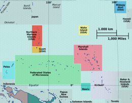
South Tarawa (Gilbertese: Tarawa Teinainano) is the capital and hub of the Republic of Kiribati and home to more than half of Kiribati's population.[2] The South Tarawa population centre consists of all the small islets from Betio in the west to Bonriki and Tanaea in the north-east, connected by the South Tarawa main road, with a population of 63,439 as of 2020[update].[1]
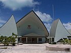
South Tarawa is home to most of the government, commercial and education facilities in Kiribati including the Port and the High Court at Betio, the State House, Government Ministries and foreign embassies and High Commissions in Bairiki, the University of the South Pacific campus in Teaoraereke, the House of Assembly in Ambo, the Kiribati Teacher College and King George V and Elaine Bernacchi School, the Government High School, is in Bikenibeu,[3] and the Tungaru central hospital in Nawerewere. The Roman Catholic Diocese is based in Teaoraereke, the Kiribati Uniting Church in Antebuka, the National Spiritual Assembly of the Bahá’ís of Kiribati in Bikenibeu, and the Church of Jesus Christ of Latter-day Saints in Eita.[4]
^ ab"Kiribati Census Report 2020 Volume 1" (PDF). National Statistics Office, Ministry of Finance and Economic Development, Government of Kiribati. Archived from the original (PDF) on 30 September 2013. Retrieved 17 August 2020.
^Country files at earth-info.nga.mil Archived 12 August 2005 at the Wayback Machine
^"6. South Tarawa" (PDF). Office of Te Beretitent – Republic of Kiribati Island Report Series. 2012. Retrieved 28 April 2015.
^"South Tarawa Island Report". Government of Kiribati.
SouthTarawa (Gilbertese: Tarawa Teinainano) is the capital and hub of the Republic of Kiribati and home to more than half of Kiribati's population. The...
SouthTarawa, which has 56,388 inhabitants as of 2015[update], half of the country's total population. The atoll was the site of the Battle of Tarawa...
42694; 172.97556 The Battle of Tarawa was fought on 20–23 November 1943 between the United States and Japan at the Tarawa Atoll in the Gilbert Islands,...
the United Kingdom, becoming a sovereign state in 1979. The capital, SouthTarawa, now the most populated area, consists of a number of islets, connected...
Buota in the South, with a combined population of 6,629 as of 2015[update]. It is administratively separate from neighbouring SouthTarawa, and is governed...
the country. It is located in its capital, SouthTarawa, which is a group of islets in the atoll of Tarawa in the Gilbert Islands, precisely on Bonriki...
Macedonia Europe Sofia Bulgaria Europe SouthTarawa Kiribati Oceania SouthTarawa is a settlement on the atoll of Tarawa. St. George's Grenada North America...
Betio is the largest township of Kiribati's capital city, SouthTarawa, and the country's main port. The settlement is located on a separate islet at the...
districts, which were known as the Northern, Central, and Southern Gilberts. (Tarawa was once a separate district as well). At one time, a subset of the northern...
southern Pacific have also often been called the South Sea Islands, and their inhabitants have been called South Sea Islanders. The Hawaiian Islands have often...
commemorated at the Coast Watchers' Memorial on the islet of Betio in SouthTarawa, the site of a massacre by beheading of New Zealand military and civilian...
Banaba Tarawa Northern Gilbert Islands Central Gilbert Island Southern Gilbert Islands Line Islands Four of the former districts (including Tarawa) lie...
High School Nonouti George Eastman High School North Tarawa Immaculate Heart College SouthTarawa Church of God High School Moroni High School - Also has...
Tarawa even if there is a bridge connecting it to Bonriki and SouthTarawa. "SouthTarawa Island Report 2012". Government of Kiribati.[permanent dead link]...
the local population and attracting tourists to the island from nearby SouthTarawa. While the island is prone to drought, in normal years the rainfall is...
annual rainfall is about 4 m, compared with about 2 m on Tarawa Atoll and 1 m in the far south of Kiribati. Rainfall on Butaritari is enhanced during an...
association and the National Championships are based in the capital city, SouthTarawa. The competition reunites only temporary council teams (one council team...
A sign on SouthTarawa, Kiribati discussing the threat of sea level rise to the island, with its highest point being only three metres above sea level...
largest city: Jayapura) Micronesia (metro, urban or proper largest city: Tarawa) Polynesia (metro, urban or proper largest city: Honolulu) The predominant...
) of which 27 km are paved in SouthTarawa (2001). The longest stretch of road travels from SouthTarawa to North Tarawa. Ports and harbours include Banaba...
the Tarawa atoll, part of the island country of Kiribati. It is part of a nearly continuous chain of settlements along the islands of SouthTarawa, which...
It is headquartered at Bonriki International Airport on the island of Tarawa in the Gilbert Islands. Regional charter flights, medical evacuation, and...
Enderbury Island, 63 km (39 mi) west-southwest. The capital of Kiribati, SouthTarawa, lies 1,765 km (1,097 mi) to the west. As of 2015[update], the population...
 Global Information