This article needs additional citations for verification. Please help improve this article by adding citations to reliable sources. Unsourced material may be challenged and removed. Find sources: "Kiribati" – news · newspapers · books · scholar · JSTOR(October 2023) (Learn how and when to remove this template message)
Independent and Sovereign Republic of Kiribati
Kiribati(Gilbertese)
Flag
Coat of arms
Motto: Te Mauri, te Raoi ao te Tabomoa ("Health, Peace and Prosperity")
Unitary parliamentary republic with an executive presidency
• President
Taneti Maamau
• Vice-President
Teuea Toatu
Legislature
House of Assembly
Independence from the United Kingdom
• Granted
12 July 1979
• Treaty of Tarawa
20 September 1979
Area
• Total
811.19[3] km2 (313.20 sq mi) (172nd)
Population
• 2021[4] estimate
121,388 (192nd)
• Density
151.9/km2 (393.4/sq mi) (55th)
GDP (PPP)
2023 estimate
• Total
$297 million
• Per capita
$2,381[5]
GDP (nominal)
2023 estimate
• Total
$248 million
• Per capita
$1,989[5]
HDI (2021)
0.624[6] medium (136th)
Currency
Australian dollar ($)[7] (AUD)
Time zone
UTC+12, +13, +14
Driving side
left
Calling code
+686
ISO 3166 code
KI
Internet TLD
.ki
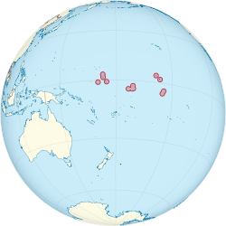
Kiribati (/ˌkɪrɪˈbæs/ⓘKIRR-ih-BASS),[8] officially the Independent and Sovereign Republic of Kiribati (Gilbertese: [Ribaberiki] Kiribati),[9][10][11] is an island country in the Micronesia subregion of Oceania in the central Pacific Ocean. Its permanent population is over 119,000 as of the 2020 census, with more than half living on Tarawa atoll. The state comprises 32 atolls and one remote raised coral island, Banaba. Its total land area is 811 km2 (313 sq mi)[12] dispersed over 3,441,810 km2 (1,328,890 sq mi) of ocean.
The islands' spread straddles the equator and the 180th meridian, although the International Date Line goes around Kiribati and swings far to the east, almost reaching 150°W. This brings Kiribati's easternmost islands, the southern Line Islands south of Hawaii, into the same day as the Gilbert Islands and places them in the most advanced time zone on Earth: UTC+14.
Kiribati gained its independence from the United Kingdom, becoming a sovereign state in 1979. The capital, South Tarawa, now the most populated area, consists of a number of islets, connected by a series of causeways. These comprise about half the area of Tarawa Atoll. Prior to its independence, the country had exported phosphate, but those mines are no longer viable. Fisheries and export of copra drive much of the economy. Kiribati is one of the least developed countries in the world and is highly dependent on international aid for its economy.
Kiribati is a member of the Pacific Community, Commonwealth of Nations, the International Monetary Fund, the World Bank, and the Organisation of African, Caribbean and Pacific States, and became a full member of the United Nations in 1999.[13][14][15] As an island nation, the islands are vulnerable to climate change and tsunamis. Addressing climate change has been a central part of its international policy, as a member of the Alliance of Small Island States.
^"About Kiribati – Kiribati For Travellers – Kiribati National Tourism Office".
^ abKiribati Census 2020. Retrieved 21 June 2022.
^"Kiribati profile – Facts". BBC. 23 May 2013. Retrieved 23 July 2020.
^"Kiribati | Data". data.worldbank.org. Retrieved 25 November 2022.
^ ab"World Economic Outlook database: April 2023". April 2023. Retrieved 20 July 2023.
^"Human Development Report 2021/2022" (PDF). United Nations Development Programme. 8 September 2022. Archived (PDF) from the original on 9 October 2022. Retrieved 10 October 2022.
^Kiribati dollar is not the official currency.
^"Kiribati". Encyclopædia Britannica. Retrieved 27 July 2010. "Kiribati: definition of Kiribati in Oxford dictionary (British & World English)". Oxford University Press. Archived from the original on 27 May 2016. Retrieved 31 December 2014.
^Kiribati. The World Factbook.
^Publications Office — Interinstitutional style guide — Annex A5 — List of countries, territories and currencies. Europa (web portal). Retrieved 29 January 2016.
^"Kiribati profile – Facts". BBC. 23 May 2013. Retrieved 23 July 2020.
^"Kiribati: 2011 Article IV Consultation-Staff Report, Informational Annexes, Debt Sustainability Analysis, Public Information Notice on the Executive Board Discussion, and Statement by the Executive Director for Kiribati". International Monetary Fund Country Report No. 11/113. 24 May 2011. Retrieved 4 October 2011.
^In February 2021, Kiribati announced it would be withdrawing from the Pacific Islands Forum in a joint statement with Marshall Islands, Nauru, and the Federated States of Micronesia after a dispute regarding Henry Puna's election as the forum's secretary-general.
^"Five Micronesian countries leave Pacific Islands Forum". RNZ. 9 February 2021. Retrieved 9 February 2021.
^"Pacific Islands Forum in crisis as one-third of member nations quit". The Guardian. 8 February 2021. Retrieved 9 February 2021.
Kiribati (/ˌkɪrɪˈbæs/ KIRR-ih-BASS), officially the Independent and Sovereign Republic of Kiribati (Gilbertese: [Ribaberiki] Kiribati), is an island country...
Events in the year 2024 in Kiribati. President: Taneti Maamau Vice President: Teuea Toatu Source: 1 January - New Year's Day 8 March – International Women's...
1°25′N 173°00′E / 1.417°N 173.000°E / 1.417; 173.000 Kiribati consists of 32 atolls and one island in an expanse of ocean equivalent in size to the...
Gilbertese or taetae ni Kiribati, also Kiribati (sometimes Kiribatese), is an Austronesian language spoken mainly in Kiribati. It belongs to the Micronesian...
Television Kiribati Ltd, or TV Kiribati, was the sole, state-owned service in Kiribati. Established in 2002, it broadcast "local and foreign programmes"...
Demographic features of the population of Kiribati include population density, ethnicity, education level, health of the populace, economic status, religious...
The Kiribati dollar is one of the two official currencies of Kiribati. The Kiribati coins are pegged at 1:1 ratio to the Australian dollar, the other...
Tarawa is an atoll and the capital of the Republic of Kiribati, in the Micronesia region of the central Pacific Ocean. It comprises North Tarawa, which...
The Republic of Kiribati's per capita Gross National Product of US$1,420 (2010) makes it the poorest country in Oceania. Phosphates had been profitably...
Teinainano) is the capital and hub of the Republic of Kiribati and home to more than half of Kiribati's population. The South Tarawa population centre consists...
The flag of Kiribati (Gilbertese: buraki ni Kiribati) is red in the upper half with a gold frigatebird (Fregata minor, in Gilbertese: te eitei) flying...
The islands which now form the Republic of Kiribati have been inhabited for at least seven hundred years, and possibly much longer. The initial Austronesian...
(secondary coordinates) This is a list of all of the islands of Kiribati. The Republic of Kiribati consists of 32 atolls and one raised coral island. These islands...
Air Kiribati (pronounced Air /ˌkɪrɪˈbæs/) is the flag carrier of the Republic of Kiribati and operates scheduled passenger services to 20 atolls spread...
The following article outlines transport in Kiribati. There are 670 km of highways in Kiribati (1996 est.) of which 27 km are paved in South Tarawa (2001)...
island of Kiribati in the Pacific Ocean. A solitary raised coral island west of the Gilbert Island Chain, it is the westernmost point of Kiribati, lying...
Kiribati, a country in Oceania comprising 32 atolls and reef islands and one raised coral island, observes three time zones, ranging from UTC+12:00 to...
Politics of Kiribati takes place in a framework of a parliamentary representative democratic republic, whereby the Beretitenti, President of Kiribati, is both...
The president of Kiribati (Gilbertese: Beretitenti) is the head of state and head of government of Kiribati. Following a general election, by which citizens...
"Kunan Kiribati" (English: "Song of Kiribati"), also known by its incipit, "Teirake Kaini Kiribati" (Gilbertese pronunciation: [tei̯ɾake kaːi̯ni kiɾibæsi];...
In Kiribati, there are no longer official administrative divisions but it is possible to divide Kiribati geographically into one isolated island and three...
Ocean atoll in the northern Line Islands. It is part of the Republic of Kiribati. The name is derived from the English word "Christmas" written in Gilbertese...
Contemporary Kiribati culture is centered on the family, the church and the sea. Kiribati folk music is generally based around chanting or other forms...
 Global Information