For a former local government area with the same name that existed in the area prior to 1994, see Shire of South Gippsland (former).
Local government area in Victoria, Australia
Shire of South Gippsland Victoria
Location in Victoria
Population
29,576 (2018)[1]
• Density
8.9733/km2 (23.241/sq mi)
Established
1994
Gazetted
2 December 1994[2]
Area
3,296 km2 (1,272.6 sq mi)[1]
Mayor
Cr Nathan Hersey
Council seat
Leongatha
Region
Gippsland
State electorate(s)
Gippsland South
Federal division(s)
Monash
Website
Shire of South Gippsland
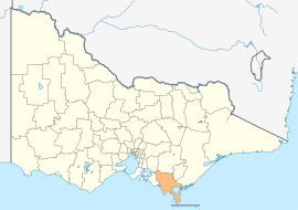
LGAs around Shire of South Gippsland:
Cardinia
Baw Baw
Latrobe
Bass Coast
Shire of South Gippsland
Wellington
Bass Strait
Bass Strait Flinders Council (Tasmania)
Bass Strait
The Shire of South Gippsland is a local government area in Victoria, Australia, located in the south-eastern part of the state. It covers an area of 3,296 square kilometres (1,273 sq mi) and, in June 2018, had a population of 29,576.
It includes the towns of Leongatha, Korumburra, Foster, Poowong, Mirboo North and Meeniyan. It was formed in 1994 from the amalgamation of the former Shire of South Gippsland with the Shire of Mirboo, and parts of the Shire of Korumburra and Shire of Woorayl.[2]
The Shire is governed and administered by the South Gippsland Shire Council; its seat of local government and administrative centre is located at the council headquarters in Leongatha, it also has a service centre located in Mirboo North. The Shire is named after the Gippsland region, in which the LGA occupies the southernmost portion, including Wilsons Promontory at the southern tip of the Australian continent.
^ ab"3218.0 – Regional Population Growth, Australia, 2017-18: Population Estimates by Local Government Area (ASGS 2018), 2017 to 2018". Australian Bureau of Statistics. Australian Bureau of Statistics. 27 March 2019. Retrieved 25 October 2019. Estimated resident population, 30 June 2018.
^ abVictoria Government Gazette – Online Archive (1837–1997). "S94 of 1994: Order estg (Part 6) the Shire of South Gippsland". State Library of Victoria. State Government of Victoria (published 2 December 1994). p. 3. Retrieved 10 January 2014.
and 21 Related for: South Gippsland Shire information
The Shire of SouthGippsland is a local government area in Victoria, Australia, located in the south-eastern part of the state. It covers an area of 3...
sub–regions or districts: West Gippsland (roughly equivalent to the Baw Baw Shire) SouthGippsland (Bass Coast and SouthGippsland Shires) the Latrobe Valley...
The Shire of East Gippsland is a local government area in Gippsland, Victoria, Australia, located in the eastern part of the state. It covers an area...
(1874– ) • Mandurang South (1906–1986) • Marong (Bullock Creek) • Mia Mia (Meadow Valley, Spring Plains (in Mitchell Shire)) Mount Camel (1959–1970)...
Victoria. It is located on the SouthGippsland Highway, 120 kilometres (75 mi) south-east of Melbourne, in the SouthGippslandShire local government area. At...
foothills of the Strzelecki Ranges, SouthGippslandShire, Victoria, Australia, located 135 kilometres (84 mi) south-east of Melbourne. At the 2021 census...
The Gippsland line (also known as the Orbost railway line or Bairnsdale railway line) is a railway line serving the Latrobe Valley and Gippsland regions...
The SouthGippsland railway line is a partially closed railway line in Victoria, Australia. It was first opened in 1892, branching from the Orbost line...
town in the foothills of the Strzelecki Ranges, SouthGippslandShire, located 135 kilometres (84 mi) south-east of Melbourne. At the 2021 census, Leongatha...
and Yarram. The electorate includes all of SouthGippslandShire and the southern parts of Wellington Shire. Industries include agriculture, timber production...
SouthGippsland Railway was a tourist railway located in SouthGippsland, Victoria, Australia. It controlled a section of the former SouthGippsland railway...
Stephens elected Wellington Shire mayor". Gippsland Times. Retrieved 14 November 2020. Local Government in Victoria. "Wellington Shire Council". Department of...
Victorian Government as a Member of the Panel of Administrators at SouthGippslandShire Council. The Council was dismissed by the Victorian Government following...
Many of the shire's larger towns are located along the Princes Highway and Gippsland railway line, which cross the southern part of the shire. From west...
rural LGA covering a larger rural area is usually called a shire and is governed by a shire council. Local councils have the same administrative functions...
Goon North 3812 Nyora 3987 (shared SouthGippslandShire and Shire of Baw Baw) Officer South 3809 Pakenham South 3810 Pakenham Upper 3810 Rythdale 3810...
population of 80,114. The Shire of East Gippsland, also called Far East Gippsland, covers two-thirds (66%) of East Gippsland's area and holds half (50%)...
Reopening the SouthGippsland railway line as far as Leongatha is continuing to feature as a prominent issue for the region. A SouthGippslandShire Council...
 Global Information