The South Fork Flathead River is a major river in Northwestern Montana in the northwest United States.[2] It is one of the three main forks of the Flathead River, a tributary of the Clark Fork River (the Pend Oreille River). The north-northwest trending river is about 98 miles (158 km) long, making it the second longest tributary of the Flathead River.
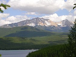
Hungry Horse Reservoir with Great Northern Mountain beyond
The river begins in the Bob Marshall Wilderness south of Glacier National Park, as does the Middle Fork Flathead River, at the confluence of two streams, Danaher Creek and Youngs Creek, between the Flathead Range and the Swan Range. For some 40 miles (64 km), the river flows freely north-northwest, meandering through a forested and undeveloped valley. The river enters a narrow gorge, running north, then begins to enter the backwater of Hungry Horse Reservoir after receiving Meadow Creek from the left. Hungry Horse Reservoir occupies much of the lower half of the river, covering 97 square miles (250 km2). The reservoir trends north then northwest, and the river then passes through the arched Hungry Horse Dam, just a few miles above the mouth. After it leaves the dam, the river enters a narrow gorge and, exiting the canyon for the final time, runs northwest past the town of Hungry Horse, then joins the Flathead River, just a few miles below its headwaters at the North Fork and Middle Forks' convergence.[3]
^ ab"South Fork Flathead River". Geographic Names Information System. United States Geological Survey, United States Department of the Interior.
^"South Fork Flathead River". Geographic Names Information System. United States Geological Survey, United States Department of the Interior. 4 April 1980. Retrieved 2009-08-29.
^Woessner, William; Potts, Donald F.; Running, Steven W.; Kimball, John S.; DeLuca, Thomas H.; Fagre, Daniel B.; Makepeace, Seth; Hendrix, Marc S.; Johnnie, N. Moore; Lorang, Mark S.; Ellis, Bonnie K. (30 July 2004). "Flathead River Basin Hydrologic Observatory, Northern Rocky Mountains" (PDF). Consortium of Universities for the Advancement of Hydrologic Science. www.cuahsi.org. Archived from the original (PDF) on 27 June 2006. Retrieved 2009-08-29.
and 22 Related for: South Fork Flathead River information
southwest into Flathead Lake, then after a journey of 158 miles (254 km), empties into the Clark Fork. The river is part of the Columbia River drainage basin...
SouthForkFlatheadRiver is a major river in Northwestern Montana in the northwest United States. It is one of the three main forks of the Flathead River...
needs to support aquatic life in river systems. The lake is downstream of Hungry Horse Dam on the SouthForkFlatheadRiver. The Hungry Horse Dam is managed...
States, on the SouthForkFlatheadRiver in the Rocky Mountains of northwest Montana. It is located in Flathead National Forest in Flathead County, about...
The North ForkFlatheadRiver (Ktunaxa: kqaskanmituk ) is a 153-mile (246 km) river flowing through British Columbia, Canada, south into the U.S. state...
Bitterroot River Spotted Bear River White River Whitefish River Stillwater RiverSouthForkFlatheadRiver Graves Creek Aeneas Creek St. Regis River Bitterroot...
refers to the Pend Oreille River as the Clark Fork. If the lengths of the North ForkFlathead, main Flathead, Clark Fork and Pend Oreille are added together...
River for the entire Flathead-Clark Fork-Pend Oreille river system. For most of the first half of the 19th century the Clark Forkriver and surrounding region...
range is bounded by the SouthForkFlatheadRiver to the east, the FlatheadRiver to the north and northwest, the Swan River to the west, and lie to the...
Dam (Montana) Flathead Lake (Montana) Swan River (Montana) Whitefish River (Montana) Stillwater River (Montana) SouthForkFlatheadRiver (Montana) Hungry...
is a stream in the U.S. state of Montana. It is a tributary to SouthForkFlatheadRiver. According to tradition, Addition Creek was named in celebration...
Spotted Bear River is a stream in the U.S. state of Montana. It is a tributary to the SouthForkFlatheadRiver. Spotted Bear River was named in 1861 by...
Brazos River, a tributary of the Brazos River in Texas North ForkFlatheadRiver, a tributary of the FlatheadRiver in Montana, which delineates the western...
Lowland south of the Canada–United States border. The river proper begins with the merging of three main tributaries, namely the North Fork, Middle Fork and...
to the south and north. To the south the Bitterroot Valley filled as far as Sula, Montana, 286 miles (460 km). To the north the FlatheadRiver basin became...
Mamie Creek may refer to: Mamie Creek (SouthForkFlatheadRiver tributary), a stream in Iowa Mamie Creek (Iowa), a stream in Montana This disambiguation...
Flathead National Forest is a national forest in the western part of the U.S. state of Montana. The forest lies primarily in Flathead County, south of...
Creek may refer to: Maggie Creek (SouthForkFlatheadRiver tributary), a stream in Montana Maggie Creek (Humboldt River tributary), a stream in Nevada This...
Service Salmon River in Oregon Ontonagon River, Michigan Wilson Creek Red River, New Mexico Lower FlatheadRiver Loxhatchee River Taunton River White Clay...
The Deep ForkRiver (Deep Fork of the North Canadian) is an Oklahoma tributary of the North Canadian River. The headwaters flow from northern Oklahoma...
order from headwater (Confluence of North Fork and Middle ForkFlatheadRiver) to mouth (Clark ForkRiver). Dams are listed in order from headwater (Little...
 Global Information