Middle Fork Flathead River, South Fork Flathead River, Swan River (Montana)
• right
Stillwater River, North Fork Flathead River
National Wild and Scenic River
Type
Wild 97.9 miles (157.6 km) Scenic 40.7 miles (65.5 km) Recreational 80.4 miles (129.4 km)
Designated
October 12, 1976[5]
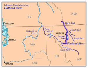
The Flathead River (Salish: člq̓etkʷ ntx̣ʷetkʷ, ntx̣ʷe, Kutenai: kananmituk),[6] in the northwestern part of the U.S. state of Montana, originates in the Canadian Rockies to the north of Glacier National Park and flows southwest into Flathead Lake, then after a journey of 158 miles (254 km), empties into the Clark Fork. The river is part of the Columbia River drainage basin, as the Clark Fork is a tributary of the Pend Oreille River, a Columbia River tributary. With a drainage basin extending over 8,795 square miles (22,780 km2) and an average discharge of 11,380 cubic feet per second (322 m3/s), the Flathead is the largest tributary of the Clark Fork and constitutes over half of its flow.[7]
^ abU.S. Geological Survey Geographic Names Information System: Flathead River
^Google Earth elevation for GNIS coordinates
^Cite error: The named reference fischer was invoked but never defined (see the help page).
^ abcMontana Water Resources Data, 2004, USGS
^"National Wild and Scenic Rivers System" (PDF). rivers.gov. National Wild and Scenic Rivers System. Archived from the original (PDF) on January 6, 2023. Retrieved January 5, 2023.
^Tachini, Pete (2010). Seliš nyoʻnuntn, Medicine for the Salish language : English to Salish translation dictionary (2nd ed.). Pablo, MT: Salish Kootenai College Press. p. 242. ISBN 9781934594063.
^"USGS 12389000 Clark Fork near Plains MT" (PDF). USGS. Retrieved August 2, 2012.
The FlatheadRiver (Salish: člq̓etkʷ ntx̣ʷetkʷ, ntx̣ʷe, Kutenai: kananmituk), in the northwestern part of the U.S. state of Montana, originates in the...
Missoula of the era of the last interglacial. Flathead Lake is a natural lake along the mainline of the FlatheadRiver. It was dammed in 1930 by Kerr Dam at its...
The Flathead Indian Reservation, located in western Montana on the FlatheadRiver, is home to the Bitterroot Salish, Kootenai, and Pend d'Oreilles tribes...
Look up flathead or Flathead in Wiktionary, the free dictionary. Flathead may refer to: Flathead people, one of three tribes of the Confederated Salish...
The flathead catfish (Pylodictis olivaris), also called by several common names including mudcat or shovelhead cat, is a large species of North American...
the Middle Fork of the FlatheadRiver. The locations necessitated specialized whitewater river professionals to perform the river stunts and provide the...
basin of the Flathead Ice Lobe and 286 miles (460 km) up the Little Bitterroot River to Niarada some 132 miles (212 km) above the FlatheadRivers mouth at...
The Confederated Salish and Kootenai Tribes of the Flathead Reservation (Montana Salish: Séliš u Ql̓ispé, Kutenai: k̓upawiȼq̓nuk) are a federally recognized...
The FlatheadRiver Bridge otherwise known as the Red Bridge is an abandoned steel truss bridge located at the south end of 4th Ave in Columbia Falls, Montana...
The Middle Fork FlatheadRiver is a 92-mile (148 km) river in western Montana in the United States, forming the southwestern boundary of Glacier National...
on the South Fork FlatheadRiver in the Rocky Mountains of northwest Montana. It is located in Flathead National Forest in Flathead County, about fifteen...
and including a portion of the FlatheadRiver in southeastern British Columbia. The full drainage basin of the river and its tributaries accounts for...
FlatheadRiver, the main inflow of Flathead Lake and a tributary of the Columbia River via the Clark Fork River and the Pend Oreille River. The river...
the Flathead Nation in Montana. The Flathead Reservation is home to the Kootenai and Pend d'Oreilles tribes also. Bitterroot Salish or Flathead originally...
Area. Other specially-designated areas in the forest include Flathead Wild and Scenic River, Jewel Basin Hiking Area, and the Coram Experimental Forest...
located at river mile 72 of the FlatheadRiver (116 river kilometer). Built in 1938, it raises the level and increases the size of Flathead Lake near Polson...
the Columbia River. Clark Fork River Bull River Thompson River Little Thompson River Vermilion River Queer Creek FlatheadRiver Jocko River Little Bitterroot...
Horse on the FlatheadRiver; Lake Koocanusa on the Kootenai River; Lake Elwell on the Marias River; Clark Canyon on the Beaverhead River; Yellowtail on...
Boundary Creek, Cameron Lake, Forum Peak, Long Knife Peak, North Fork FlatheadRiver and Frozen Lake. In geographic terms, the boundary is at the Canada–United...
Cabinet Mountains, the river receives the FlatheadRiver from the east near Paradise. It receives the Thompson River from the north near Thompson Falls in...
feature extending approximately 1,600 km (1,000 mi) from Flathead Lake, Montana, to the Liard River, just south of the British Columbia–Yukon border near...
mullet, among others. The flathead grey mullet is a mainly diurnal coastal species that often enters estuaries and rivers. It usually schools over sand...
Clark, two on the Flathead, eight on the Yakima, and two on the Owyhee. Averaging a major dam every 72 miles (116 km), the rivers in the Columbia watershed...
 Global Information