Abbeville, Greenwood, Laurens, Newberry, Union, Chester, York
Highway system
South Carolina State Highway System
Interstate
US
State
Scenic
← SC 71
→ SC 75
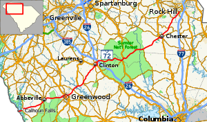
South Carolina Highway 72 (SC 72) is a 124.860-mile (200.943 km) state highway, traversing interior portions of the South Carolina Piedmont region. This route is part of a multi two-state route 72 that begins at Athens, Georgia and ends at Rock Hill, South Carolina. The route connects many smaller communities outside major metropolitan areas and is roughly parallel with Interstate 85 (I-85) to the north and I-20 and I-77 to the south and east. The route shares the longest concurrency in the state with SC 121, from Whitmire to Rock Hill.
^"Highway Logmile Report". South Carolina Department of Transportation. Retrieved December 3, 2020.
^"Highway Logmile Report". South Carolina Department of Transportation. Retrieved December 3, 2020.
^"Highway Logmile Report". South Carolina Department of Transportation. Retrieved December 3, 2020.
^"Highway Logmile Report". South Carolina Department of Transportation. Retrieved December 3, 2020.
^"Highway Logmile Report". South Carolina Department of Transportation. Retrieved December 3, 2020.
^"Highway Logmile Report". South Carolina Department of Transportation. Retrieved December 3, 2020.
^"Highway Logmile Report". South Carolina Department of Transportation. Retrieved December 3, 2020.
and 21 Related for: South Carolina Highway 72 information
SouthCarolinaHighway72 (SC 72) is a 124.860-mile (200.943 km) state highway, traversing interior portions of the SouthCarolina Piedmont region. This...
North CarolinaHighway72 (NC 72) is a primary state highway in the U.S. state of North Carolina that serves the communities of Red Springs and Lumberton...
SouthCarolinaHighway 9 (SC 9) is a 259.570-mile (418 km) major state highway in the U.S. state of SouthCarolina. The highway travels from Cherry Grove...
SouthCarolinaHighway 121 (SC 121) is a 134.200-mile (215.974 km) major state highway that travels north and south in central parts of the U.S. state...
SouthCarolinaHighway 28 (SC 28) is a 131.220-mile (211.178 km) primary state highway in the U.S. state of SouthCarolina. It consists of two segments...
SouthCarolinaHighway 5 (SC 5) is a 51.719-mile (83.234 km) primary state highway in the U.S. state of SouthCarolina. The highway, signed as north–south...
SouthCarolinaHighway 56 (SC 56) is a 63.700-mile (102.515 km) primary state highway in the state of SouthCarolina. The highway provides a back country...
highways are numbered 72: AH72 Asian Highway72 E72 European route E72 Snowy Mountains Highway Alberta Highway72 Newfoundland and Labrador Route 72 Highway...
SouthCarolinaHighway 41 (SC 41) is a 121.5-mile (195.5 km) state highway, connecting the Charleston region with eastern portions of the Pee Dee region...
SouthCarolinaHighway 122 (SC 122), also known as Dave Lyle Boulevard, is a 5.740-mile (9.238 km) state highway in Rock Hill, York County, South Carolina...
SouthCarolinaHighway 66 (SC 66) is a 18.550-mile (29.853 km) primary state highway in the state of SouthCarolina. It serves to connect the community...
SouthCarolinaHighway 75 (SC 75) is an 8.110-mile (13.052 km) state highway in the U.S. state of SouthCarolina. The highway is mainly rural. The western...
state highways in SouthCarolina. These state highways are owned and maintained by the U.S. state of SouthCarolina, through the SouthCarolina Department...
SouthCarolinaHighway 97 (SC 97) is a 89.800-mile (144.519 km) state highway in the U.S. state of SouthCarolina. The highway connects Camden, Great Falls...
SouthCarolinaHighway 6 (SC 6) is a 116.092-mile (186.832 km) primary state highway in the U.S. state of SouthCarolina. It extends from US 76 in Ballentine...
SouthCarolinaHighway 460 (SC 460) is a 7.5-mile (12.1 km) primary state highway in the U.S. state of SouthCarolina. It serves as an bypass of SC 160...
SouthCarolinaHighway 39 (SC 39) is a 100.889-mile (162.365 km) primary state highway in the U.S. state of SouthCarolina. The highway connects various...
 Global Information