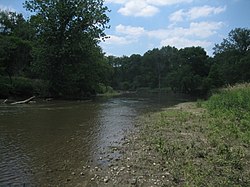
The South Branch Kishwaukee River flowing through Kishwaukee River State Fish and Wildlife Area, summer 2007
Physical characteristics
Source
• location
Shabbona Township, DeKalb County, Illinois
• coordinates
41°46′24″N88°54′06″W / 41.7733333°N 88.9016667°W / 41.7733333; -88.9016667 (South Branch Kishwaukee River origin)
• elevation
900 ft (270 m)
Mouth
• location
Confluence with the Kishwaukee River near Rockford, Illinois
• coordinates
42°12′00″N88°59′01″W / 42.2°N 88.9836111°W / 42.2; -88.9836111 (South Branch Kishwaukee River mouth)
• elevation
709 ft (216 m)
Length
64 mi (103 km)
Discharge
• location
Fairdale, IL
• average
305 cu/ft. per sec.[1]
Basin features
Progression
South Branch Kishwaukee River → Kishwaukee → Rock → Mississippi → Gulf of Mexico
GNIS ID
422087
Map all coordinates using OpenStreetMap
Download coordinates as:
KML
GPX (all coordinates)
GPX (primary coordinates)
GPX (secondary coordinates)
The South Branch Kishwaukee River is a 63.6-mile-long (102.4 km)[2] tributary of the Kishwaukee River in northern Illinois. The South Branch is the main branch of the Kishwaukee River, joining it 10.6 miles (17.1 km)[2] above its confluence with the Rock River. The South Branch flows through DeKalb County; in 2007 flooding along the tributary inundated areas of DeKalb County and Sycamore, Illinois.
Another stream, also named South Branch Kishwaukee River, flows through Kane County and McHenry County, joining the main stem of the Kishwaukee east of Marengo.
^"USGS Current Conditions for USGS 05439500 SOUTH BRANCH KISHWAUKEE RIVER NR FAIRDALE IL".
^ abU.S. Geological Survey. National Hydrography Dataset high-resolution flowline data. The National Map, accessed May 19, 2011
and 20 Related for: South Branch Kishwaukee River information
coordinates) The SouthBranchKishwaukeeRiver is a 63.6-mile-long (102.4 km) tributary of the KishwaukeeRiver in northern Illinois. The SouthBranch is the main...
the Boone County line. The SouthBranch of the KishwaukeeRiver originates near Shabbona on the Cropsey Moraine. The river flows north to Genoa, where...
East BranchSouthBranchKishwaukeeRiver, in northern Illinois, is a 23.7-mile-long (38.1 km) tributary of the KishwaukeeRiver, by way of the South Branch...
North BranchKishwaukeeRiver is a 17.1-mile-long (27.5 km) tributary of the KishwaukeeRiver in northern Illinois. The North BranchKishwaukeeRiver northeast...
(231 ha) of land along the SouthBranchKishwaukeeRiver in DeKalb County. While the state acquired the 570-acre (231 ha) parcel south of the riverbank, DeKalb...
fell on August 23 and 24 in DeKalb County, at DeKalb, the South BranchKishwaukeeRiver rose to its highest level since 1983 and its second highest level...
the smaller river hills." Illinois River Kaskaskia River - named for the Kaskaskia people KishwaukeeRiver and SouthBranchKishwaukeeRiver – derived from...
key questions about passenger rail between Rockford and Chicago". Rock River Current. Retrieved 7 September 2023. Johnston, Bob (9 July 2023). "Illinois...
is a remaining 350-foot (107 m) concrete arch bridge spanning the KishwaukeeRiver east of Belvidere. Its preservation seems likely due to sturdy construction...
Mukwonago River Des Plaines River Root River Rock RiverKishwaukeeRiver (IL) Piscasaw Creek Pecatonica River Sugar River Little Sugar River West Branch Sugar...
Illinois. However, most trains terminate in Crystal Lake, Illinois. A branch line to McHenry, Illinois operates during weekday rush hours in the peak...
Michigan to its northeast, the Mississippi River to its west, and the Wabash and Ohio rivers to its south. Of the fifty U.S. states, Illinois has the...
I&M Canal trail system Deer Grove trail system Des Plaines River Trail system North Branch Trail system Palos Trail system Poplar Creek trail system Sag...
525) Kankakee Community College (No. 520) Kaskaskia College (No. 501) Kishwaukee College (No. 523) Lake Land College (No. 517) Lewis and Clark Community...
to contrast with the Lincoln farm. The Reuben Moore Home, occupied by a branch of the family starting in 1856, was the place of Abraham and Sarah Bush...
bell are four niches, each with a larger-than-life figure representing a branch of the armed services. Inscribed on the base are the names of Illinoisans...
years by Civil War General Ambrose Burnside. The Cairo & Vincennes became a branch line of the Southern Railway before its trail section shut down in the late...
and along the Upper Mississippi River. It runs from Wabasha, Minnesota in the north to Rock Island, Illinois in the south. In its northern portion, it is...
 Global Information