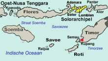
Group of islands in the Lesser Sunda Islands, Indonesia
Solor Archipelago
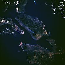
Space Shuttle Photograph of Solor Archipelago
The Solor Archipelago (Indonesian: Kepulauan Solor) is a group of islands in the Lesser Sunda Islands, Indonesia, lying to the east of Flores and the west of the Alor Strait and the Alor Archipelago. To the north is the west part of the Banda Sea, while to the south across the Savu Sea lies the island of Timor. The largest islands are, from west to east, Solor, Adonara, and Lembata (formerly known as Lomblen), although there are many small islands as well.
Administratively, the islands of Solor and Adonara are included within the East Flores Regency, while Lembata (with smaller offshore islands) forms its regency (kabupaten), the Lembata Regency. Both regencies lie within the province of East Nusa Tenggara. The islands are listed below with their areas and their populations at the 2010 Census[1] and the 2020 Census,[2] and according to the official estimates for mid-2023,[3] together with the number of administrative districts (kecamatan) on each island.
Name
Area in km2
Population Census 2010
Population Census 2020
Population Estimate mid 2023
Number of districts
Solor Island
226.34
27,041
34,029
36,000
3
Adonara Island
529.75
104,514
126,469
132,400
8
Lembata Island
1,266.39
117,829
135,930
141,400
9
Totals
2,022.48
249,384
296,428
309,800
20
In addition to the national language of Indonesian, the population also speaks Lamaholot as a lingua franca. There are also many local languages, for example, Adonara which is spoken on Adonara and Solor.
On the South coast of Lembata, the village of Lamalera (pop. 2,500) is known for its hunting of sperm whales and other deep-sea species. This is allowed under International Whaling Commission regulations around aboriginal whaling but conservationists worry that commercial whaling is being carried out in the garb of aboriginal whaling.[4] Lamalera and Lamakera (on the neighbouring island of Solor) are the last two remaining Indonesian whaling communities.
^Biro Pusat Statistik, Jakarta, 2011.
^Badan Pusat Statistik, Jakarta, 2021.
^Badan Pusat Statistik, Jakarta, 28 February 2024, Kabupaten Flores Timur Dalam Angka 2024 (Katalog-BPS 1102001.5306)
^"A Whaling Way of Life Under Threat (Published 2017)". The New York Times.
The SolorArchipelago (Indonesian: Kepulauan Solor) is a group of islands in the Lesser Sunda Islands, Indonesia, lying to the east of Flores and the west...
Solor is a volcanic island located off the eastern tip of Flores island in the Lesser Sunda Islands of Indonesia, in the SolorArchipelago. The island...
all of the adjacent islands of Adonara and Solor to the east of Flores (and both part of the SolorArchipelago), with some much smaller offshore islands...
Including Komodo and Rinca islands off its west coast (but excluding the SolorArchipelago to the east of Flores), the land area is 14,731.67 km2, and the population...
Flores in the SolorArchipelago. To the east lies Lembata, formerly known as Lomblen. Adonara is the highest of the islands of the archipelago, reaching an...
Islands, also known as Lomblen island; it is the largest island of the SolorArchipelago, in the Lesser Sunda Islands, Indonesia. It forms a separate regency...
move to either Dutch Batavia or Portuguese-controlled Timor and the SolorArchipelago. Portuguese presence in the region had started since 1520 when they...
three small offshore islands together forming the eastern part of the SolorArchipelago, and has its administrative seat (capital) in Lewoleba. The population...
Island Pengah Kecil Island Batupengah Island Rote Island Savu Solor Islands Adonara Lembata Solor Sumba Halura Island Timor, divided between Indonesia West...
archipelago; to the west is the Alor Strait, which separates it from the SolorArchipelago. To the south is the Ombai Strait, and 72 kilometres (45 mi) away...
Alor Strait (also Alloo Strait) divides the SolorArchipelago from the Alor Archipelago, in the Lesser Sunda Islands of Indonesia. It lies mainly between...
Sunda Islands Greater Sunda Islands Lesser Sunda Islands Alor ArchipelagoSolorArchipelago Tanimbar Islands Talaud Islands Tayandu Islands Tengah Islands...
Menipo is an island in the Lesser Sunda Islands in Indonesia, separated from Timor Island by a narrow strait. It is 7,328 metres (24,042 ft) long and 700...
Lewoleba is a town and also the capital of the Lembata Regency, East Nusa Tenggara province of Indonesia. It is located in Nubatukan District on Lembata...
Map of the islands of East Nusa Tenggara, including Raijua Geography Archipelago Sawu islands Area 36 km2 (14 sq mi) Administration Indonesia Demographics...
the first Europeans to establish a colonial presence in the Indonesian Archipelago. Their quest to dominate the source of the spices that sustained the...
Lamakera is a village in Indonesia, on the east tip of Solor Island. It was known for being the place where the most manta rays are killed. It was featured...
is a transit harbour used by sea transportation from and to Lamakera in Solor Island, Larantuka in East Flores and Lewoleba in Lomblen Island. Vaisutis...
place to land since it was situated to the south of their base in the SolorArchipelago. The area was dominated by the Ambeno kingdom, which was sometimes...
Portuguese: [ˈkaβu ˈveɾðɨ]), officially the Republic of Cabo Verde, is an archipelago and island country of West Africa in the central Atlantic Ocean, consisting...
The Mergui Archipelago (also Myeik Archipelago or Myeik Kyunzu; Burmese: မြိတ်ကျွန်းစု) is located in far southern Myanmar (Burma) and is part of the...
support one of the world's highest levels of biodiversity. The Indonesian archipelago has been a valuable region for trade since at least the seventh century...
Archipelago. On Java, he found a skullcap and a femur (Java Man) dating to the late Pliocene or early Pleistocene at the Trinil site along the Solo River...
trading posts, forts, and missions on the islands of Ternate, Ambon, and Solor among others. The height of Portuguese missionary activities, however, came...
 Global Information