Average monthly flow (m3/s) at the Dagana hydrometric station over the period 1903-1974[1]
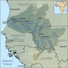
The Senegal River (Arabic: نَهر السنغَال, romanized: Nehr es-Sinigâl, French: Fleuve Sénégal, Wolof: Dexug Senegaal) is a 1086-kilometre-long (675 mi) river in West Africa; much of its length marks part of the border between Senegal and Mauritania. It has a drainage basin of 270000 km2 (100000 sq mi), a mean flow of 680 m3/s (24,000 cu ft/s), and an annual discharge of 21.5 km3 (5.2 cu mi). Important tributaries are the Falémé River, Karakoro River, and the Gorgol River. The river divides into two branches once it passes Kaédi The left branch, called the Doué, runs parallel to the main river to the north. After 200 km (120 mi) the two branches rejoin a few kilometers downstream of Podor.
In 1972 Mali, Mauritania and Senegal founded the Organisation pour la mise en valeur du fleuve Sénégal (OMVS) to manage the river basin. Guinea joined in 2005. As of 2012[update], only very limited use was made of the river for the transportation of goods and passengers. The OMVS have looked at the feasibility of creating a navigable channel 55 m (180 ft) in width between the small town of Ambidédi in Mali and Saint-Louis, a distance of 905 km (562 mi). It would give landlocked Mali a direct route to the Atlantic Ocean.
The aquatic fauna in the Senegal River basin is closely associated with that of the Gambia River basin, and the two are usually combined under a single ecoregion known as the Senegal-Gambia Catchments. Only three species of frogs and one fish are endemic to this ecoregion.
The river has two large dams along its course, the Manantali Dam in Mali and the Maka-Diama Dam downstream on the Mauritania-Senegal border. In between is the Félou Hydroelectric Plant, built in 1927, but replaced in 2014. The construction of the Gouina Hydroelectric Plant upstream of Felou at Gouina Falls began in 2013.
^Hydrographic data for Dagana, Senegal 1903-1974, Unesco International Hydrological Programme, retrieved 24 May 2012.
southwest. Senegal nearly surrounds The Gambia, a country occupying a narrow sliver of land along the banks of the Gambia River, which separates Senegal's southern...
The history of Senegal is commonly divided into a number of periods, encompassing the prehistoric era, the precolonial period, colonialism, and the contemporary...
westward through Senegal and The Gambia to the Atlantic Ocean at the city of Banjul. It is navigable for about half that length. The river is strongly associated...
border with Senegal. The Gambia penetrates more than 320 km into Senegal, from the Atlantic coast to the center of Senegal along the Gambia River, which bisects...
Sahara as well as in the Senegalriver valley. It was fought between the Sanhadja Berber tribes and Muslim populations in the river valley, led by Lamtuna...
of rivers in Senegal. This list is arranged by drainage basin, with respective tributaries indented under each larger stream's name. SénégalRiver Falémé...
overview of and topical guide to Senegal: Senegal – sovereign country located south of the SénégalRiver in West Africa. Senegal is bound by the Atlantic Ocean...
Gambia River but is otherwise surrounded by Senegal. The four major rivers, the SenegalRiver, the Saloum River, the Gambia River and the Casamance River, drain...
in the northern regions of Senegal where they constitute 15% of the population. This region is irrigated by the SenegalRiver valley, overlaps southern...
The French conquest of Senegal started in 1659 with the establishment of Saint-Louis, Senegal, followed by the French capture of the island of Gorée from...
from east to west and range from traces of tropical forest along the SénégalRiver to brush and savanna in the southeast. Only sandy desert is found in...
along the west coast of Africa in the 16th and 17th centuries, the SenegalRiver was often postulated to be the seaward end of the Niger. The Niger Delta...
(Bambara: ߞߊߦߌ tr. Kayi, Soninké: Xaayi) is a city in western Mali on the SénégalRiver with a population of 127,368 at the 2009 census. Kayes is the capital...
There are various ethnic groups in Senegal. According to "CIA World Factbook: Senegal" (2019 estimates), the ethnic groups are Wolof (39%); Fula (probably...
Agriculture is one of the dominant parts of Senegal's economy, even though Senegal lies within the drought-prone Sahel region. As only about 5% of the...
southwest. Senegal also borders The Gambia, a country occupying a narrow sliver of land along the banks of the Gambia river, which separates Senegal's southern...
between Florence and Bologna Futa River in Chile Futa, Ghana, a community in Ghana Futa Tooro, a region along the SenegalRiver Federal Unemployment Tax Act...
This article describes the system of transport in Senegal, both public and private.This system comprises roads (both paved and unpaved), rail transport...
river. Management of such basins becomes the responsibility of the countries sharing it. Nile Basin Initiative, OMVS for SenegalRiver, Mekong River Commission...
France laid claim to the territories of present-day Mauritania, from the SenegalRiver area northwards. In 1901, Xavier Coppolani took charge of the imperial...
the Gambia River Valley (OMVG), and the Organization for the Development of the SenegalRiver Valley (OMVS). During the Cold War, Senegal was part of...
States (ECOWAS) to originate in Nouakchott. Mostly ferry traffic on the SenegalRiver (from north to south) Nouadhibou Nouakchott Rosso Kaedi Bogue None as...
 Global Information