 Global Information
Schuylkill River information
| Schuylkill River | |
|---|---|
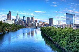 The Schuylkill River with Center City Philadelphia's skyline in the background, September 2007 | |
 The river's watershed drains parts of the western side of Broad Mountain and the ridge-and-valley Appalachians of the southcentral Pennsylvania Coal Region. | |
| Etymology | "hidden/skulking creek" in Dutch |
| Location | |
| Country | United States |
| State | Pennsylvania |
| Counties | Philadelphia, Montgomery, Chester, Berks, Schuylkill |
| Cities | Philadelphia, Norristown, Pottstown, Reading |
| Physical characteristics | |
| Source | East Branch Schuylkill River |
| • location | Tuscarora, Schuylkill County, Pennsylvania, United States |
| • coordinates | 40°46′24″N 76°01′20″W / 40.77333°N 76.02222°W |
| • elevation | 1,540 ft (470 m) |
| 2nd source | West Branch Schuylkill River |
| • location | Minersville, Schuylkill County, Pennsylvania, United States |
| • coordinates | 40°42′51″N 76°18′46″W / 40.71417°N 76.31278°W |
| • elevation | 1,140 ft (350 m) |
| Source confluence | |
| • location | Schuylkill Haven, Schuylkill County, Pennsylvania, United States |
| • coordinates | 40°38′01″N 76°10′49″W / 40.63361°N 76.18028°W |
| • elevation | 520 ft (160 m) |
| Mouth | Delaware River |
• location | Philadelphia, Pennsylvania, United States |
• coordinates | 39°53′04″N 75°11′41″W / 39.88444°N 75.19472°W |
• elevation | 0 ft (0 m) |
| Length | 135 mi (217 km) |
| Basin size | 2,000 sq mi (5,200 km2) |
| Discharge | |
| • location | Philadelphia |
| • average | 2,875 cu ft/s (81.4 m3/s) |
| • minimum | 995 cu ft/s (28.2 m3/s) |
| • maximum | 40,300 cu ft/s (1,140 m3/s) |
| Discharge | |
| • location | Berne |
| • average | 1,120 cu ft/s (32 m3/s) |
| Basin features | |
| Tributaries | |
| • left | Little Schuylkill River, Perkiomen Creek |
| • right | Tulpehocken Creek, French Creek |
Schuylkill River | ||||||||||||||||||||||||||||||||||||||||||||||||||||||||||||||||||||||||||||||||||||||||||||||||||||||||||||||||||||||||||||||||||||||||||||||||||||||||||||||||||||||||||||||||||||||||||||||||||||||||||||||||||||||||||||||||||||||||||||||||||||||||||||||||||||||||||||||||||||||||||||||||||||||||||||||||||||||||||||||||||||||||||||||||||||||||||||||||||||||||||||||||||||||||||||||||||||||||||||||||||||||||||||||||||||||||||||||||||||||||||||||||||||||||||||||||||||||||||||||||||||||||||||||||||||||||||||||||||||||||||||||||||||||||||||||||||||||||||||||||||||||||||||||||||||||||||||||||||||||||||||||||||||||||||||||||||||||||||||||||||||||||||||||||||||||||||||||||||||||||||||||||||||||||||||||||||||||||||||||||||||||||||||||||||||||||||||||||||||||||||||||||||
|---|---|---|---|---|---|---|---|---|---|---|---|---|---|---|---|---|---|---|---|---|---|---|---|---|---|---|---|---|---|---|---|---|---|---|---|---|---|---|---|---|---|---|---|---|---|---|---|---|---|---|---|---|---|---|---|---|---|---|---|---|---|---|---|---|---|---|---|---|---|---|---|---|---|---|---|---|---|---|---|---|---|---|---|---|---|---|---|---|---|---|---|---|---|---|---|---|---|---|---|---|---|---|---|---|---|---|---|---|---|---|---|---|---|---|---|---|---|---|---|---|---|---|---|---|---|---|---|---|---|---|---|---|---|---|---|---|---|---|---|---|---|---|---|---|---|---|---|---|---|---|---|---|---|---|---|---|---|---|---|---|---|---|---|---|---|---|---|---|---|---|---|---|---|---|---|---|---|---|---|---|---|---|---|---|---|---|---|---|---|---|---|---|---|---|---|---|---|---|---|---|---|---|---|---|---|---|---|---|---|---|---|---|---|---|---|---|---|---|---|---|---|---|---|---|---|---|---|---|---|---|---|---|---|---|---|---|---|---|---|---|---|---|---|---|---|---|---|---|---|---|---|---|---|---|---|---|---|---|---|---|---|---|---|---|---|---|---|---|---|---|---|---|---|---|---|---|---|---|---|---|---|---|---|---|---|---|---|---|---|---|---|---|---|---|---|---|---|---|---|---|---|---|---|---|---|---|---|---|---|---|---|---|---|---|---|---|---|---|---|---|---|---|---|---|---|---|---|---|---|---|---|---|---|---|---|---|---|---|---|---|---|---|---|---|---|---|---|---|---|---|---|---|---|---|---|---|---|---|---|---|---|---|---|---|---|---|---|---|---|---|---|---|---|---|---|---|---|---|---|---|---|---|---|---|---|---|---|---|---|---|---|---|---|---|---|---|---|---|---|---|---|---|---|---|---|---|---|---|---|---|---|---|---|---|---|---|---|---|---|---|---|---|---|---|---|---|---|---|---|---|---|---|---|---|---|---|---|---|---|---|---|---|---|---|---|---|---|---|---|---|---|---|---|---|---|---|---|---|---|---|---|---|---|---|---|---|---|---|---|---|---|---|---|---|---|---|---|---|---|---|---|---|---|---|---|---|---|---|---|---|---|---|---|---|---|---|---|---|---|---|---|---|---|---|---|---|---|---|---|---|---|---|---|---|---|---|---|---|---|---|---|---|---|---|---|---|---|---|---|---|---|---|---|---|---|---|---|---|---|---|---|---|---|---|---|---|---|---|---|---|---|---|---|---|---|---|---|---|---|---|---|---|---|---|---|---|---|---|---|---|---|---|---|---|---|---|---|---|---|---|---|---|---|---|---|---|---|---|---|---|---|---|---|---|---|---|---|---|---|---|---|---|---|---|---|---|---|---|---|---|---|---|---|---|---|---|---|---|---|---|---|---|---|---|---|---|---|---|---|---|---|---|---|---|---|---|---|---|---|---|---|---|---|---|---|---|---|---|---|---|---|---|---|---|---|---|---|---|---|---|---|---|---|---|---|---|---|---|---|---|---|---|---|---|---|---|---|---|---|---|---|---|---|---|---|---|---|---|---|---|---|---|---|---|---|---|---|---|---|---|---|---|---|---|---|---|---|---|---|---|---|---|---|---|---|---|---|---|---|---|---|---|---|---|---|---|---|---|---|---|---|---|---|---|---|---|---|---|---|---|---|---|---|---|---|---|---|---|---|---|---|---|---|---|---|---|---|---|---|---|---|---|---|---|---|---|---|---|---|---|
| ||||||||||||||||||||||||||||||||||||||||||||||||||||||||||||||||||||||||||||||||||||||||||||||||||||||||||||||||||||||||||||||||||||||||||||||||||||||||||||||||||||||||||||||||||||||||||||||||||||||||||||||||||||||||||||||||||||||||||||||||||||||||||||||||||||||||||||||||||||||||||||||||||||||||||||||||||||||||||||||||||||||||||||||||||||||||||||||||||||||||||||||||||||||||||||||||||||||||||||||||||||||||||||||||||||||||||||||||||||||||||||||||||||||||||||||||||||||||||||||||||||||||||||||||||||||||||||||||||||||||||||||||||||||||||||||||||||||||||||||||||||||||||||||||||||||||||||||||||||||||||||||||||||||||||||||||||||||||||||||||||||||||||||||||||||||||||||||||||||||||||||||||||||||||||||||||||||||||||||||||||||||||||||||||||||||||||||||||||||||||||||||||||
The Schuylkill River (/ˈskuːlkɪl/ SKOOL-kil,[1] locally /ˈskuːkəl/ SKOO-kəl)[2] is a river in eastern Pennsylvania. It flows for 135 miles (217 km)[3] from Pottsville southeast to Philadelphia, where it joins the Delaware River as one of its largest tributaries.
The river's watershed of about 2,000 sq mi (5,180 km2) lies entirely within the state of Pennsylvania, stretching from the Ridge-and-Valley Appalachians through the Piedmont to the Atlantic Plain.
Historically the Schuylkill lay within the territory of the Susquehannock and Lenape peoples. In 1682, William Penn founded the city of Philadelphia between the Schuylkill and Delaware rivers on lands purchased from the Lenape. The Schuylkill River became key in the development of the city and the surrounding region.
While long used for transport, the river was made fully navigable via the Schuylkill Canal in 1825, followed by the construction of the Reading Railroad Main Line in 1838 and the Pennsylvania Railroad Schuylkill Branch in 1884. Through these corridors, millions of tons of anthracite coal flowed down the Schuylkill from Pennsylvania's Coal Region.[a] The canal was abandoned in 1931, while the Schuylkill Expressway was completed in 1959.
Industrial pollution and mining silt plagued the river in the 19th and 20th centuries. Early concerns over water quality led to the creation of Fairmount Park in 1812. Protections came with the 1972 passing of the Clean Water Act, and the Schuylkill was designated as the first Pennsylvania Scenic River in 1978. Water quality has largely recovered in the years since.
The Schuylkill River above Fairmount Dam has been a major rowing venue since the founding of the Schuylkill Navy in 1858. In recent decades the Schuylkill River Trail cycle and foot path has been constructed along the river. The Schuylkill Heritage Corridor was designated a Pennsylvania Heritage Park in 1995 and a National Heritage Area in 2000 to promote the river's historic, environmental, and recreational significance.[4]
- ^ Oxford Dictionary: definition of Schuylkill River (American English)
- ^ "Definition of SCHUYLKILL". www.merriam-webster.com.
- ^ U.S. Geological Survey. National Hydrography Dataset high-resolution flowline data. The National Map Archived 2012-03-29 at the Wayback Machine, accessed April 1, 2011
- ^ "History of Schuylkill River Greenways NHA". schuylkillriver.org. Schuylkill River Greenway Association. Retrieved 6 January 2024.
Cite error: There are <ref group=lower-alpha> tags or {{efn}} templates on this page, but the references will not show without a {{reflist|group=lower-alpha}} template or {{notelist}} template (see the help page).