Mountain range of the Transverse Ranges in California, United States
San Gabriel Mountains
Summits in the eastern San Gabriel Mountains, Angeles National Forest, San Bernardino County, California. The main peaks are: Telegraph Peak 8,985 feet (2,739 m) (left), Cucamonga Peak, 8,859 feet (2,700 m) (center), and Ontario Peak 8,693 feet (2,650 m) (center right), as seen from Baldy Bowl on Mount Baldy.
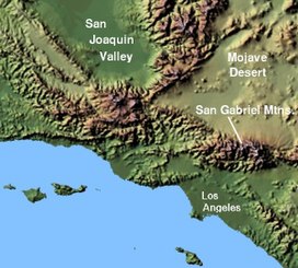
The San Gabriel Mountains (Spanish: Sierra de San Gabriel) comprise a mountain range located in northern Los Angeles County and western San Bernardino County, California, United States.[1] The mountain range is part of the Transverse Ranges and lies between the Los Angeles Basin and the Mojave Desert, with Interstate 5 to the west and Interstate 15 to the east. The range lies in, and is surrounded by, the Angeles and San Bernardino National Forests, with the San Andreas Fault as its northern border.
The highest peak in the range is Mount San Antonio, commonly referred to as Mt. Baldy. Mount Wilson is another notable peak, known for the Mount Wilson Observatory and the antenna farm that houses many of the transmitters for local media. The observatory may be visited by the public. On October 10, 2014, Barack Obama designated the area the San Gabriel Mountains National Monument.[2] The Trust for Public Land has protected more than 3,800 acres (1,500 ha) of land in the San Gabriel Mountains, its foothills, and the Angeles National Forest.[3]
^"San Gabriel Mountains". Geographic Names Information System. United States Geological Survey, United States Department of the Interior. Retrieved May 3, 2009.
^"President Obama Designates San Gabriel Mountains National Monument". whitehouse.gov. October 10, 2014. Retrieved October 10, 2014 – via National Archives.
^"Los Angeles Natural Lands". The Trust for Public Land. Retrieved August 3, 2018.
and 25 Related for: San Gabriel Mountains information
acres of public lands in the SanGabrielMountains of the Transverse Ranges. The effort to protect the SanGabrielMountains began more than a century earlier...
landforms and other features include the following: the SanGabrielMountains to the north; the San Rafael Hills to the west, with the Los Angeles Basin...
: 255 In late-April, the pair found an isolated fire road in the SanGabrielMountains. Bittaker broke open the locked gate with a crowbar and replaced...
Mount San Antonio, commonly referred to as Mount Baldy or Old Baldy, is a 10,064 ft (3,068 m) summit in the SanGabrielMountains on the border of Los...
SanGabrielMountains and Sierra Pelona Mountains, primarily within Los Angeles County in southern California. The ANF manages a majority of the San Gabriel...
segment extends to the SanGabrielMountains and SanGabriel fault. The central segment includes mountains that range eastward to the San Andreas fault. The...
County, California. They include the foothills of the SanGabrielMountains, and independent low mountain ranges of hills, in the east Greater Los Angeles...
SanGabriel, Spanish for Saint Gabriel, may refer to: Mexico SanGabriel, Durango SanGabriel, Guanajuato SanGabriel, Jalisco SanGabriel Chilac, Puebla...
County, California. Located just south of the western SanGabrielMountains, the Verdugo Mountains region incorporates the cities of Burbank, Glendale,...
Pelona-San Emigdio Mountains juncture area to the western SanGabrielMountains that forms their southwestern face near Sunland and the northeastern San Fernando...
(2000–2002). In January 2023, Sands went missing while hiking in the SanGabrielMountains northeast of Los Angeles. His remains were discovered that June...
eastern SanGabrielMountains and the San Bernardino Mountains; on the east by the San Jacinto Mountains; on the south by the Temescal Mountains and Santa...
first wildfire, known as the Reservoir Fire, was reported in the SanGabrielMountains along Highway 39 near the Morris Reservoir. As the flames quickly...
Little San Bernardino Mountains, 300 miles (480 km) to the east. The frontal fault system at the base of the SanGabrielMountains extends from the San Jacinto...
parallel to and below the SanGabrielMountains, adjacent to the SanGabriel Valley overlooking the Los Angeles Basin. The San Rafael Hills contain all...
west, the Santa Monica Mountains and Chalk Hills to the south, the Verdugo Mountains to the east, and the SanGabrielMountains to the northeast. The northern...
the west of the Santa Susana Mountains. The Newhall Pass separates the Santa Susana Mountains from the SanGabrielMountains to the east. Newhall Pass is...
headwater of the SanGabriel River in Los Angeles County, California, United States. It originates at the crest of the SanGabrielMountains in the Angeles...
between the SanGabrielMountains on the northeast and the Verdugo Mountains and San Rafael Hills on the southwest. It opens into the San Fernando Valley...
 Global Information