San Bernardino, Crestline, Lake Arrowhead, Running Springs and Big Bear Lake
Range coordinates
34°12′N117°00′W / 34.2°N 117°W / 34.2; -117
Parent range
Transverse Ranges
Borders on
San Gabriel Mountains, San Jacinto Mountains and Little San Bernardino Mountains
Geology
Age of rock
Miocene and Quaternary
Type of rock
Fault-block and sedimentary
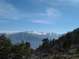
The San Bernardino Mountains are a high and rugged mountain range in Southern California in the United States.[3] Situated north and northeast of San Bernardino and spanning two California counties, the range tops out at 11,503 feet (3,506 m) at San Gorgonio Mountain – the tallest peak in Southern California.[4] The San Bernardinos form a significant region of wilderness and are popular for hiking and skiing.
The mountains were formed about eleven million years ago by tectonic activity along the San Andreas Fault, and are still actively rising. Many local rivers originate in the range, which receives significantly more precipitation than the surrounding desert. The range's unique and varying environment allows it to maintain some of the greatest biodiversity in the state.[5] For over 10,000 years, the San Bernardinos and their surroundings have been inhabited by indigenous peoples, who used the mountains as a summer hunting ground.[6]
Spanish explorers first encountered the San Bernardinos in the late 18th century, naming the eponymous San Bernardino Valley at its base. European settlement of the region progressed slowly until 1860, when the mountains became the focus of the largest gold rush ever to occur in Southern California. Waves of settlers brought in by the gold rush populated the lowlands around the San Bernardinos, and began to tap the mountains' rich timber and water resources on a large scale by the late 19th century.
Recreational development of the range began in the early 20th century, when mountain resorts were built around new irrigation reservoirs. Since then, the mountains have been extensively engineered for transportation and water supply purposes. Four major state highways and the California Aqueduct traverse the mountains today; these developments have all had significant impacts on area wildlife and plant communities.
^"San Gorgonio Mountain". Geographic Names Information System. United States Geological Survey, United States Department of the Interior. January 19, 1981. Retrieved January 29, 2012.
^Cite error: The named reference peakbagger was invoked but never defined (see the help page).
^"San Bernardino Mountains". Geographic Names Information System. United States Geological Survey, United States Department of the Interior. January 19, 1981. Retrieved January 29, 2012.
^Lancaster, p. 6
^Grinnell, pp. 1–2
^Cite error: The named reference SBCounty was invoked but never defined (see the help page).
and 22 Related for: San Bernardino Mountains information
The SanBernardinoMountains are a high and rugged mountain range in Southern California in the United States. Situated north and northeast of San Bernardino...
eastern San Gabriel Mountains and the SanBernardinoMountains; on the east by the San Jacinto Mountains; on the south by the Temescal Mountains and Santa...
the San Gabriel Mountains and the SanBernardinoMountains on the easternmost of the Transverse Ranges, and the San Jacinto and Santa Rosa Mountains on...
The Little SanBernardinoMountains are a short mountain range of the Transverse Ranges, located in southern California in the United States. They extend...
Victor Valleys, respectively on the other sides of the San Gorgonio Pass and SanBernardinoMountains from the Santa Ana River watershed that forms the bulk...
The San Gabriel Mountains (Spanish: Sierra de San Gabriel) comprise a mountain range located in northern Los Angeles County and western SanBernardino County...
The SanBernardino Sun is a paid daily newspaper in SanBernardino County. Founded in 1894, it has significant circulation in neighboring Riverside County...
initial point (datum) is at the summit of Mount SanBernardino, in the SanBernardinoMountains, in SanBernardino County, California. It is at an elevation...
San Gabriel Mountains. Gold Mountain, 8,239 feet (2,511 m), SanBernardinoMountains. Bertha Peak, 8,205 feet (2,501 m), SanBernardinoMountains. Frazier...
approximately 30 mi (50 km) from the SanBernardinoMountains southeast to the Santa Rosa Mountains. The San Jacinto Mountains are the northernmost of the Peninsular...
people, who have historically lived in the SanBernardinoMountains. The tribe was formerly named the San Manuel Band of Mission Indians. The other federally...
and an attempted bombing, occurred at the Inland Regional Center in SanBernardino, California, United States. The perpetrators, Syed Rizwan Farook and...
California. It serves as a primary route into the SanBernardinoMountains, both from the Riverside–SanBernardino metropolitan area from the south and the Mojave...
Cajón or Paso del Cajón) is a mountain pass between the SanBernardinoMountains to the east and the San Gabriel Mountains to the west in Southern California...
reservoir in the western United States, located in the SanBernardinoMountains in SanBernardino County, California. It is a snow and rain-fed lake, having...
San Bernardino Valley, northeast of the San Gabriel Mountains, and northwest of the SanBernardinoMountains, and south of the Barstow area. The Mojave...
wildfire that burned 22,744 acres (9,204 ha; 35.538 sq mi; 92.04 km2) in SanBernardino and Riverside counties of California from September to November 2020...
Spanish founded Mission San Gabriel Arcangel in 1771, south of the San Gabriel Mountains and southwest of the SanBernardinoMountains. With the establishment...
 Global Information