For the river in Indonesia, see Sampit River (Indonesia).
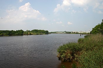
Sampit River (tidal) just above Georgetown
The Sampit River begins in a swampy area of western Georgetown County, South Carolina, USA. It flows in an easterly direction to Winyah Bay at Georgetown.[1] Only small crafts can navigate the upper parts of the river. The lower river merges into the bay and is deepened by tidal flows, and (to Georgetown harbor) by dredging.[2][3][4]
During colonial and antebellum years, areas near the river were developed extensively for rice cultivation,[5] on large plantations[6] dependent on labor of African slaves.[7] They created complex earthworks with dams and other elements to irrigate the rice fields using tidewaters.[8][9] In this and other areas of the Low Country, African Americans developed the Gullah people and culture,[10] a distinct creole culture with strong connections through culture, language and cuisine to West African peoples.[11]
^"Sampit River at Georgetown, SC". United States Geological Survey. Retrieved 23 March 2023.
^"Project Fact Sheet: Georgetown Harbor, SC" (PDF). U.S. Army Corps of Engineers, Charleston District. 10 April 2018. Retrieved 23 March 2023.
^Sokoloski, Chris (20 June 2022). "Engineers outline plan for dredging port's inner harbor". Coastal Observer. Retrieved 23 March 2023.
^James, Andrew (2 January 2023). "CCU study suggests another option for Georgetown's inner harbor silting issue". ABC15 News. Retrieved 23 March 2023.
^David Soliday (2010). "Aerial photograph of the Sampit River flowing through Friendfield Plantation". National Museum of African American History & Culture. Photograph by David Soliday. Smithsonian. Retrieved 23 March 2023.
^"Friendfield Plantation, Georgetown County". National Register Properties in South Carolina. South Carolina Department of Archives and History. Retrieved 23 March 2023.
^Ivey, Page (2023). "Discover Georgetown, A Quiet Spot on the Coast". Discover South Carolina. South Carolina Department of Parks, Recreation and Tourism.
^"Sampit River". South Carolina Picture Project. 2022. Retrieved 23 March 2023.
^Linder, Suzanne (23 August 2022) [Originally published 20 June 2016]. "Rice Trunks". South Carolina Encyclopedia. University of South Carolina, Institute for Southern Studies. Retrieved 23 March 2023.
^Tommy Howard; Georgetown Times (22 April 2022). "Georgetown County's natural beauty intertwined with its history". The Post and Courier. Retrieved 23 March 2023.
^Sumpter, Althea (16 September 2020) [Originally published 31 March 2006]. "Geechee and Gullah Culture". New Georgia Encyclopedia. Retrieved 23 March 2023.
The SampitRiver begins in a swampy area of western Georgetown County, South Carolina, USA. It flows in an easterly direction to Winyah Bay at Georgetown...
Sampit is a large town located in East Kotawaringin Regency, Central Kalimantan. Previously a timber port town, it has grown to be a medium-sized community...
stream's name. All rivers in South Carolina drain to the Atlantic Ocean. Little River Pee Dee River Old Dead RiverSampitRiver Black River Black Mingo Creek...
(900 km) Kapuas River (600 km) Kahayan River (600 km) Katingan River (600 km) Mentaya (Sampit) River (400 km) Seruyan River (350 km) Lamandau River (300 km)...
estuary that is the confluence of the Waccamaw River, the Pee Dee River, the Black River, and the SampitRiver in Georgetown County, in eastern South Carolina...
Pawan River Keriau River Pembuang River Sambas RiverSampitRiver Sembakung River Sesayap River Apauwar River Baliem (Vriendschaps) River Becking River Bewani...
and the presence of drainage channels (traceable to the mouths of island rivers), indicate that the Sunda Shelf was once a stable, dry, low-relief land...
services was securing federal funding for a high span bridge over the SampitRiver in Georgetown, South Carolina, allowing sea-going vessels to travel upstream...
the United States in 20 years. The ship Snow Goose, anchored in the SampitRiver 5 mi (8.0 km) west of Georgetown, clocked a 120-mile-per-hour (193 km/h)...
Duahre where pearls were found, was identified with the name of the SampitRiver. Hitha (Yta) - a province ruled by Datha, possibly Etiwaw (Eutaw), a...
Carolina who also became a planter. He developed a plantation along the SampitRiver for indigo and rice from 1734 onward, based on the use of enslaved labor...
River Lamandau River Arut River Mendawai River Pembuang RiverSampitRiver Berau River Kelai River Mahakam River Belayan River Kaso River Lawa River Telen...
chief) (alive in 1870), associated with the Bear River Massacre, Idaho, US Sampit, a town on the SampitRiver, Borneo, Indonesia This disambiguation page lists...
The Solo River (known in Indonesian as Bengawan Solo, with Bengawan being an Old Javanese word for river, and Solo derived from the old name for Surakarta)...
locations for the church: an inland settlement on the Black River and Winyah on the SampitRiver and Winyah Bay at the location of today's Georgetown. In...
Lamandau River Arut River Mendawai River Pembuang RiverSampitRiver Drainage basins of Kalimantan List of drainage basins of Indonesia List of rivers of Indonesia...
The Citarum River (Sundanese: Walungan Citarum) is the longest and largest river in West Java, Indonesia. It is the third longest river in Java, after...
Indonesia, between the Sampit and Barito rivers. It is found in blackwater swampy areas just between the Barito and Sampitrivers; the holotype was collected...
Barito Main mouth to Java Sea The Barito River is the second longest river in Borneo after the Kapuas River with a total length of 1,090 km (680 mi) and...
second-longest river on the island of New Guinea, after Sepik River (1,146 km) and the third largest in Oceania by discharge (5,500 m3/s) volume after Fly River (7...
Kapuas main mouth The Kapuas River (or Kapoeas River) is a river in the Indonesian part of Borneo island, at the geographic center of Maritime Southeast...
 Global Information