5,500 m3/s (190,000 cu ft/s)[2]
5,922.9 m3/s (209,170 cu ft/s)[3]
• maximum
25,000 m3/s (880,000 cu ft/s)
Basin features
Tributaries
• left
Tariku River
• right
Taritatu River
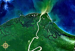
The Mamberamo (Indonesian: Sungai Mamberamo) is the second-longest river on the island of New Guinea, after Sepik River (1,146 km) and the third largest in Oceania by discharge (5,500 m3/s) volume after Fly River (7,500 m3/s) and Sepik (7,000 m3/s). It is located in the Indonesian province of Papua. It is the second largest river in Indonesia by volume of discharge after Kapuas River (6,500 m3/s) and also the widest.[4]
The river is formed from the confluence of its upper tributaries, the Tariku and Taritatu Rivers in the Lakes Plains region, an interior basin with extensive freshwater swamp forests and grasslands. It flows northwards between the Van Rees Range (Pegunungan Van Rees) and Foja Mountains through a series of rapids and gorges. The last 160 km of the river are navigable.[5] In the coastal lowlands, the river is lined with marshes and forms a broad river delta. The Mamberamo discharges into the Pacific Ocean at the northern point of Point D'Urville or Cape Narwaku (Tanjung Narwaku).
The river's huge valley is home to various uncontacted peoples and incredible biodiversity. In the 1990s, the Indonesian Government had plans to construct a large hydroelectric dam on the Mamberamo that would have submerged much of the area. This plan was shelved after the Indonesian financial crisis from 1998 to 1999, but there are concerns by environmental groups that it could be resurrected sometime in the future. At present, the Mamberamo remains the second largest river in the world to be completely unfragmented by dams in its catchment, behind only the relatively nearby Fly.[4]
The Mamberamo area also broadly refers to several nearby mountain ranges, including the Van Rees and Foja Mountains (also known as Foya), which were the subject of a recent rapid biological assessment conducted by Conservation International, the Indonesian Institute of Sciences, and Cenderawasih University. The scientific team discovered the first new bird species from New Guinea in 60 years, and a wealth of other new plants and animals. The Foya Mountains appear to be a globally outstanding repository of biodiversity.
^Joesron, Loebis. "Country Report Implementation of Demonstration Project Mamberamo River Basin INDONESIA".
^Joesron, Loebis. "Country Report Implementation of Demonstration Project Mamberamo River Basin INDONESIA".
^Rendy, Firmansyah. "Grafik Neraca Air Pulau Papua".
^ ab"Fragmentation and Flow Regulation of the World's Large River Systems" (PDF). Archived from the original (PDF) on 2012-03-30. Retrieved 2013-01-12.
^"Mamberamo River". Encyclopaedia Britannica. Accessed 7 June 2020
The Mamberamo (Indonesian: Sungai Mamberamo) is the second-longest river on the island of New Guinea, after Sepik River (1,146 km) and the third largest...
northern coast of Papua province, Indonesia, near the mouth of the MamberamoRiver. They have various been classified either as heavily Papuanized Austronesian...
This is a list of the longest rivers on Earth. It includes river systems over 1,000 kilometres (620 mi) in length. There are many factors, such as the...
the Asmat region. The region has 40 major rivers, 12 lakes, and 40 islands.[citation needed] The MamberamoRiver is the region's largest and runs through...
the largest rivers are the Mamberamo, Sepik and Ramu. Mamberamo was born from the confluence of two large inland rivers. Tariku comes from the west to...
The Fly River is the third longest river in the island of New Guinea, after the Sepik River and MamberamoRiver, with a total length of 1,060 km (660 mi)...
or Rouffaer River is a river in the northern part of the Indonesian province of Papua. It is one of the major tributary of MamberamoRiver with a total...
River Wawoi River List of rivers of Samoa Digul MamberamoRiver Tariku River Taritatu River Van Daalen River Lists of rivers List of rivers of Europe List...
rainbowfish, peacock rainbowfish, and Teczanka neonowa. It is endemic to the MamberamoRiver basin in West Papua in Indonesia and common in the aquarium trade....
Idenburg River also called Baliem River is a river in the northern part of the Indonesian province of Papua. It is the largest tributary of MamberamoRiver with...
some 300 people in Burmeso village along the mid MamberamoRiver in Mamberamo Tengah subdistrict, Mamberamo Raya Regency, Papua province, Indonesia. It is...
spoken in the village of Fuau, located along the Dijai River, a tributary to the MamberamoRiver. Clouse tentatively included Abawiri and neighboring Taburta...
Irian Jaya). The Bauzi area consists of much of the west side of lower MamberamoRiver area in northern Papua. The Bauzi people lived on hunting and gathering...
the fourth longest river in New Guinea after the Sepik River, MamberamoRiver, and Fly River. With a total length of 853 km (530 mi) and a drainage basin...
list of longest rivers of Asia. Included are all rivers over 1,000 km (620 mi) that are in Asia. List of rivers of Asia Longest Rivers of Asia Worldatlas...
The Mamberamo Lakes Plains (Dutch Meervlakte, Malay dataran danau-danau) are a large, flat low-lying area of the MamberamoRiver basin in the Indonesian...
Mountains) (Indonesian: Pegunungan Foja) are located just north of the Mamberamoriver basin in Papua, Indonesia. The mountains rise to 2,193 metres (7,195 ft)...
Bewani River Bian River Brazza River Bulaka River Digul Fly River Grime River Kampung River Kamundan River Kumbe River Lorentz (Undir) RiverMamberamo Mandobo...
isolate. Clouse (1997) removed the Lakes Plain languages of the upper MamberamoRiver in the interior of Papua from Trans–New Guinea, where Würm had placed...
Papua Province. It covers an area of 16,610 km2, and extends along the MamberamoRiver and its tributaries from the foothills of the Central Range to the...
Cenderawasih (Geelvink Bay) languages (10) Lakes Plain languages (19; upper MamberamoRiver) Tor–Kwerba languages (17) Nimboran languages (5) Skou languages (Skou)...
West Papua, between the Bird's Head Peninsula and the mouth of the MamberamoRiver. The bay is more than 300 kilometers wide. The coastline from Manokwari...
 Global Information