6,600 m3/s (230,000 cu ft/s)[4][5] to 211 km3/a (6,700 m3/s)[6]
• minimum
2,300 m3/s (81,000 cu ft/s)[3]
• maximum
32,600 m3/s (1,150,000 cu ft/s)[3]
Discharge
• location
Mawlamyine, Myanmar
• average
6,391.9 m3/s (225,730 cu ft/s)[7]
Discharge
• location
Mottama, Myanmar
• average
5,217.5 m3/s (184,250 cu ft/s)[7]
Discharge
• location
Hpa-an, Myanmar
• average
4,722.3 m3/s (166,770 cu ft/s)[9]
(Period: 2009-2013)5,280 m3/s (186,000 cu ft/s)[8]
• minimum
1,743 m3/s (61,600 cu ft/s)[8]
• maximum
17,080 m3/s (603,000 cu ft/s)[8]
Discharge
• location
Lushui, Nujiang Lisu Autonomous Prefecture, China
• average
1,437 m3/s (50,700 cu ft/s)[10]
Basin features
Tributaries
• left
Suo River, Ga River, Hka River, Hsim River, Pai River, Moei River, Gyaing River
• right
Ba River, Leng River, Pang River, Teng River, Pawn River
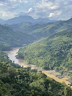
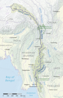
The Salween is a Southeast Asian river, about 3,289 kilometres (2,044 mi) long,[2] flowing from the Tibetan Plateau south into the Andaman Sea. The Salween flows primarily within southwest China and eastern Myanmar (Burma), with a short section forming the border of Burma and Thailand. Throughout most of its course, it runs swiftly through rugged mountain canyons. Despite the river's great length, only the last 90 km (56 mi) are navigable, where it forms a modest estuary and delta at Mawlamyine. The river is known by various names along its course, including the Thanlwin (named after Elaeocarpus sp., an olive-like plant that grows on its banks[11]) in Burma and the Nu Jiang (or Nu River, named after Nu people) in China. The commonly used spelling "Salween" is an anglicisation of the Burmese name dating from 19th-century British maps.
Due to its great range of elevation and latitude coupled with geographic isolation, the Salween basin is considered one of the most ecologically diverse regions in the world, containing an estimated 25 percent of the world's terrestrial animal species and thousands of plant species[citation needed]. Along its course the Salween provides water for agriculture and supports abundant fisheries, especially in the delta region. The Salween basin is home to numerous ethnic minority groups, whose ancestors largely originated in the Tibetan Plateau and northwest China. Starting about 5,000 years ago, people began migrating south along the river, establishing small kingdoms and city-states.
During the last 1,000 years, the Salween has defined various frontiers of the Burmese empires to the west, the Kingdom of Siam to the south, and Imperial China to the east, with the Shan States along the middle Salween being a frequently contested area. In the 19th century, the British Empire invaded Burma with Mawlamyine serving as the colonial capital for many decades. Since Burmese independence in 1948, the Salween basin has been a battleground for several fronts of the Burmese Civil War, with large areas in Shan State and Karen State (Kayin State) contested between the Burmese military and local ethnic militias.
The Salween is one of the least fragmented large river systems in Asia, with only a few small dams in the headwaters of the river and on tributaries. The river has extremely high hydropower potential, with a fall of more than 5,000 metres (16,000 ft) from its source. Since the 1970s, the Burmese and Thai governments have sought to build massive hydroelectric dams along the river. China also planned to dam the upper Salween, but in 2016 these plans were dropped in favor of establishing a national park. The future of dam projects in Myanmar and Thailand remains uncertain.
^ abCite error: The named reference sciencenet was invoked but never defined (see the help page).
^ abLehner, B., Verdin, K., Jarvis, A. (2008): New global hydrography derived from spaceborne elevation data. Eos, Transactions, AGU, 89(10): 93–94.
^ ab"Myanmar: Third GMS Corridor Town Development Project" (PDF). 2017.
^Cite error: The named reference Baronas was invoked but never defined (see the help page).
^"Bilin".
^Harunur, Rashid; Alexandra, T. Gourlan; Brittany, Marche; Kaylyn, Sheppard; Nabil, Khélif (2019). "Changes in Indian Summer Monsoon Using Neodymium (Nd) Isotopes in the Andaman Sea During the Last 24,000 years" (PDF). Earth Systems and Environment. 3 (2): 105. Bibcode:2019ESE.....3..105R. doi:10.1007/s41748-019-00105-0. S2CID 198422435.
^ ab"Salween Delta".
^ abcCHAPTER 5 NATURAL CONDITION SURVEYS(PDF).
^"Lower Salween".
^"Upper Salween".
^Mason, Francis (1851). Tenasserim: Or Notes on the Fauna, Flora, Minerals, and Nations of British Burmah and Pegu. Maulmain: American Mission Press. p. 213.
Salween is a Southeast Asian river, about 3,289 kilometres (2,044 mi) long, flowing from the Tibetan Plateau south into the Andaman Sea. The Salween flows...
proposed for the SalweenRiver. The largest of these hydro power projects is the 7,100 megawatts (9,500,000 hp) Tasang Dam on the SalweenRiver, which is to...
the SalweenRiver ("Thanlwin" in Myanmar). Thailand and Myanmar have signed an agreement for the Salween dams project, five dams on the Salween and another...
The Battle of the SalweenRiver (Chinese: 喀喇烏蘇之戰) was fought in September 1718 close to the Nagqu (i.e., SalweenRiver) in Tibet, between an expedition...
(in Russian) Река ЕНИСЕЙ Река Н.ТУНГУСКА Ganges River Yarlung Tsangpo River Река АМУР The SalweenRiver Basin Fact Sheet Euphrates Река ВИЛЮЙ ĀMŪ DARYĀ...
the mountains. The main rivers in the state are Thanlwin (SalweenRiver), Thaungyin (Moei River), Gyaing and Attaran. The government of Kayin State is split...
most groups, vast areas of the state, especially those east of the SalweenRiver, remain outside the central government's control, and in recent years...
the SalweenRiver which was garrisoned by the 2nd Burma Infantry Brigade. The position was almost impossible to defend, and had the RiverSalween, almost...
the Hengduan Mountains, along with the Yangtze to its east and the SalweenRiver (Nu Jiang in Chinese) to its west. Then the Mekong meets the China–Myanmar...
River (怒江) / (SalweenRiver) Wanma River (万马河) Hongyang River (硔养河) Mengboluo River (勐波罗河) Supa River (苏帕河) Shidian River (施甸河) Luomingba River (罗明坝河) Irrawaddy...
ဟတ်ကြီးဆည်) is a planned hydropower gravity dam to be constructed on the SalweenRiver in southeastern Myanmar. The dam site is in Myanmar’s Karen State. The...
blocked the road immediately behind the SalweenRiver. Although the Chinese Nationalist Army crossed the river with light casualties and surrounded the...
S'gaw Karen: သူမွဲကျိ) is a tributary of the SalweenRiver. Unlike most rivers in Thailand, the Moei River flows north in a northwest direction. It originates...
the basins of the Indus, Ganges and Brahmaputra rivers. It was reported to be found in the Salweenriver, the natural border between Thailand and Myanmar...
border city of Tengchong. At this point, a large area west of the SalweenRiver (Nu River) fell into the hands of the Japanese army. The 71st Army of the...
the south into the upper Malay Peninsula, to the east at least to the Salweenriver, in the farther north to below the current China border, and to the...
It is a rugged, mountainous area located between the Mekong and the SalweenRiver, with the Nam Hka flowing across it. The Wa traditionally practiced...
collectively as Lue-Khuen (ลื้อเขิน) in Thai sources. Trans-Salween states to the east of SalweenRiver had political and cultural affinity towards Lanna and...
On 27 April 2021, the KNLA captured a Myanmar Army base along the Salweenriver, bordering Thailand's Mae Sam Laep sub-district. A civilian in on the...
in the Irrawaddy River near the Thin Baw Kone village, Pakokku District. More findings have exdended its range to the SalweenRiver basin as well. Habitats...
the SalweenRiver in the west and the Mekong in the east. The basins of rivers Ping, Wang, Yom, and Nan, all tributaries of the Chao Phraya River, in...
people, the river supply amounts to 18,614 m3 per person per year. Collectively, the modern Ayeyarwady (Irrawaddy) and Thanlwin (Salween) rivers deliver >600...
Myitmaka River Bago River (Pegu River) Sittaung River Phyu Creek Kha Paung Creek Sinthay River Paunglaung RiverSalweenRiver (Thanlwin River) Ataran River Zami...
east of the Derung Valley, living in the mountains above the Nu River (SalweenRiver) near the village of Binzhongluo in northern Gongshan Derung and...
and 70 kilometres (43 mi) south of Thaton, at the mouth of Thanlwin (Salween) River. Mawlamyine was an ancient city and the first capital of British Burma...
Myanmar. It is located in the northern part of Shan State, with the SalweenRiver to its west, and sharing a border with China's Yunnan Province to the...
completely captured it by 5:30 AM. Military bases on the western bank of the SalweenRiver in Kunlong were taken by the MNDAA and both sides of the town came under...
Western Karenni States were the four Karenni states located west of the SalweenRiver: Kyebogyi, 350 square miles or 910 square kilometres, population 9,867...
upper reaches of the Jinsha (Yangtze), Lancang (Mekong) and Nujiang (Salween) rivers, in the Yunnan section of the Hengduan Mountains. The protected areas...
 Global Information