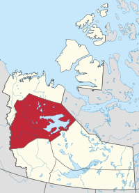
Administrative region in Northwest Territories, Canada
Sahtu Region
Administrative region
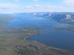
Norman Range and Kelly Lake
Norman Wells
Fort Good Hope
Tulita
Deline
Colville Lake
Location within the Northwest Territories
Country
Canada
Territory
Northwest Territories
Territorial riding
Sahtu
Settlement area
Sahtu
Regional office[1]
Norman Wells
Population
(2016)
• Total
2,554
Time zone
UTC−07:00 (MST)
• Summer (DST)
UTC−06:00 (DST)
The Sahtu Region is an administrative region in Canada's Northwest Territories. Coterminous with the settlement region described in the 1993 Sahtu Dene and Metis Comprehensive Land Claim Agreement, 41,437 km2 (15,999 sq mi) of the Sahtu is collectively owned by its Indigenous Sahtu (Dene) and Métis inhabitants. Although the region's population is predominantly First Nations, a significant non-Indigenous presence exists in Norman Wells, the regional office,[1] established in 1920 to serve the only producing oilfield in the Canadian Territories. Considered to be of vital strategic importance during World War II in the event of a Japanese invasion of Alaska, the region's petroleum resources were exploited by the United States Army with the Canol pipeline, but the project never became necessary and ultimately operated for less than one year.
Since the abandonment of the Canol project, development within the region has been more limited than in the rest of the territory. Although plans have long existed for pipelines and highways to parallel the Mackenzie River through the Sahtu en route to the Arctic Ocean, the landmark Mackenzie Valley Pipeline Inquiry recommended that a moratorium be placed on construction until local Indigenous land claims could be settled. To this day, no all-weather roads connect the Sahtu with the rest of Canada, and the contiguous North American pipeline network finds its northernmost terminus at Norman Wells, which was connected to Zama City, Alberta in 1984. Ground transportation is seasonally provided by a network of winter and ice roads, while the abandoned Canol route now forms part of the Trans Canada Trail system.[3]
Souvenir of the Sahtu Region, showing the name in colloquial use, referencing N.W.A's debut studio album Straight Outta Compton.
^ abSahtu Region
^Government of the Northwest Territories. "About Municipal and Community Affairs". Retrieved 2019-06-17.
The SahtuRegion is an administrative region in Canada's Northwest Territories. Coterminous with the settlement region described in the 1993 Sahtu Dene...
which form the SahtuRegion of the NWT. The Dene of the region are represented by the Sahtu Dene Council who, in 1993, signed the Sahtu Dene and Metis...
there is oil") is a town located in the SahtuRegion, Northwest Territories, Canada. The town, which hosts the Sahtu Regional office, is situated on the north...
BC AB SK MB ON QC NB PE NS NL YT NT NU Map all coordinates using OpenStreetMap Download coordinates as: KML GPX (all coordinates) GPX (primary coordinates)...
Community of K'asho Got'ine[pronunciation?]), is a charter community in the SahtuRegion of the Northwest Territories, Canada. It is located on a peninsula between...
parentheses): Dehcho Region (Fort Simpson) Inuvik Region (Inuvik) North Slave Region (Yellowknife and Behchoko [sub-office]) SahtuRegion (Norman Wells) South...
of Canada, the Sahtu Dene and Metis Comprehensive Land Claim Agreement, for the seven Dene and Métis communities in the SahtuRegion. It is the first...
Sachs Harbour Tsiigehtchic Tuktoyaktuk Ulukhaktok The Inuvik Region or Beaufort Delta Region is one of five administrative regions in the Northwest Territories...
The North Slave Region or Tłicho Region is one of five administrative regions in the Northwest Territories of Canada. It is the most populous of the five...
Great Bear Lake Airport (IATA: DAS, TC LID: CFF4) is a private aerodrome adjacent to Great Bear Lake, Northwest Territories, Canada. Prior permission is...
Fort Good Hope Airport (IATA: YGH, ICAO: CYGH) is located 1 nautical mile (1.9 km; 1.2 mi) southwest of Fort Good Hope, Northwest Territories, Canada....
Bear Rock (Dene: Kweteniɂaá) is a geologic formation in the SahtuRegion of the Northwest Territories located across the mouth of the Great Bear River...
Norman Wells Airport (IATA: YVQ, ICAO: CYVQ) is located adjacent to Norman Wells, Northwest Territories, Canada. North-Wright Airways has its hangar and...
Fort Confidence, located at the mouth of the Dease River on the eastern tip of the Dease Arm of Great Bear Lake, Northwest Territories, was a Hudson's...
Ford Bay Water Aerodrome (TC LID: CEL7) is located just south of Great Bear Lake, Northwest Territories, Canada. It is open from July to August. Ford Bay...
Ford Bay Airport (TC LID: CBC2) is a private aerodrome at Ford Bay, Great Bear Lake Northwest Territories, Canada. Prior permission is required to land...
Colville Lake Water Aerodrome (TC LID: CED7) is located just west of Colville Lake, Northwest Territories, Canada. It may be used for ski equipped aircraft...
Great Bear Lake Water Aerodrome (TC LID: CES9) is located 1 nautical mile (1.9 km; 1.2 mi) south of the lodge on the Dease Arm of Great Bear Lake, Northwest...
municipality on the right: Region 1 – Inuvik Region 2 – Norman Wells Region 3 – Behchokǫ̀ Region 4 – Fort Simpson Region 5 – Fort Smith Region 6 – Yellowknife Prior...
Fort Simpson Jean Marie River Nahanni Butte Sambaa Kʼe Wrigley The Dehcho Region[pronunciation?] or Deh Cho is one of five administrative regions in the...
Norman Wells Water Aerodrome (TC LID: CEU8) is located 3.5 nautical miles (6.5 km; 4.0 mi) south-southeast of Norman Wells, Northwest Territories, Canada...
Mackenzie River. The Tulita Dene First Nation is a member of the Sahtu Dene Council. Under the Sahtu Dene and Metis Comprehensive Land Claim Agreement, the First...
Tulita Airport (IATA: ZFN, ICAO: CZFN) is located adjacent to Tulita, Northwest Territories, Canada. Its hours of operation are Monday to Friday from 9am...
Slave Region is one of five administrative regions in the Northwest Territories of Canada. According to Municipal and Community Affairs the region consists...
 Global Information