SacRT generally maintains a 2 car consist, (159ft U2A/168ft CAF S/200)[5][6]
Headway
15 min (weekdays until late night)
30 min (late night and early morning weekends)[7]
Technical
System length
42.9 mi (69.0 km)[1]
Track gauge
4 ft 8+1⁄2 in (1,435 mm) standard gauge
Electrification
Overhead line, 750 V DC
Top speed
55 mph (89 km/h)[1]
System map
Show interactive map
Show static map
Legend
Watt/I-80
■
Watt/I-80 West
■
Roseville Road
■
Marconi/Arcade
■
RT Facility
Swanston
■
Royal Oaks
■
Arden/Del Paso
■
Globe
■
Dos Rios
(planned)
■
7th & Richards/
Township 9
Alkali Flat/La Valentina
■
■
Sacramento Valley
12th & I
(✱)
■
■■
7th & I/8th & H (
County
Center
)
Cathedral
Square
(
11th & K
10th & K
)
■
■■
8th & K
9th & K
■
(closed 2016)
7th & K
7th│8th & Capitol
■■■
8th & O
■■■
Archives Plaza
■■■
R Street Yard
13th Street
■■■
16th Street
■■
■
Broadway
23rd Street
■
■
4th Avenue
29th Street
■
■
City College
39th Street
■
■
Fruitridge
48th Street
■
■
47th Avenue
59th Street
■
■
Florin
University/65th Street
■
■
Meadowview
Power Inn
■
■
Morrison Creek
College Greens
■
■
Franklin
Watt/Manlove
■
■
Center Parkway
Starfire
■
■
Cosumnes River
College
Tiber
■
Butterfield
■
Mather Field/Mills
■
Zinfandel
■
Cordova
Town Center
■
Sunrise
■
Hazel
■
Iron Point
■
Glenn
■
Historic Folsom
■
Key
Blue Line ■
Two services
Gold Line ■
All services
Green Line ■
Paid parking
Bus connections
Free parking
Bike lockers available
All stops are accessible except 12th & I southbound
= Flag stop
This diagram:
view
talk
edit
Show route diagram
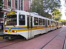
Sacramento RT Light Rail is a 42.9-mile (69.0 km) light rail system that serves the Sacramento, California area. It consists of three rail lines, 53 stations, and a fleet of 96 vehicles. It is operated by the Sacramento Regional Transit District (RT). With an average of 22,200 weekday daily boardings as of the fourth quarter of 2023, the RT light rail system is the thirteenth busiest in the United States.
^ abc"RT Fact Sheet" (PDF). Sacramento Regional Transit District. June 2015. Retrieved September 9, 2015.
^"Transit Ridership Report Fourth Quarter 2023" (PDF). American Public Transportation Association. March 4, 2024. Retrieved March 14, 2024.
^"Transit Ridership Report Fourth Quarter 2023" (PDF). American Public Transportation Association. March 4, 2024. Retrieved March 14, 2024.
^ abCite error: The named reference LR-FactSheet was invoked but never defined (see the help page).
SacramentoRTLightRail is a 42.9-mile (69.0 km) lightrail system that serves the Sacramento, California area. It consists of three rail lines, 53 stations...
connecting bus service in the Sacramento area covering 438 square miles (1,134.4 km2), SacRT also operates a large lightrail system, which ranks currently...
The Sacramento Regional Transit District, or SacramentoRT, operates a three-line urban lightrail mass transit network, serving portions of greater Sacramento...
The following is a list of all lightrail systems in the United States, ranked by ridership. Also included are some of the urban streetcar/trolley systems...
the Fresno Subdivision in Stockton. South of Downtown Sacramento, the SacramentoRTLightRail Blue Line runs adjacent to the right of way until a flyover...
Lightrail is a mode of rail-based transport, usually urban in nature. When compared to heavy rail systems like commuter rail or rapid transit (subway)...
following is a list of all lightrail systems in North America, ranked by ridership. Daily figures for American and Canadian lightrail systems are "average...
Cosumnes River College station is a side platformed SacramentoRTlightrail station in Sacramento, California, United States. The station was opened on...
(all-time list, streetcar/interurban/lightrail only) Urban rail transit Commuter rail in North America Lightrail in North America Streetcars in North...
 Global Information