 Global Information
List of Sacramento Regional Transit light rail stations information
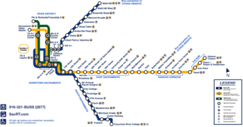
The Sacramento Regional Transit District, or Sacramento RT, operates a three-line urban light rail mass transit network, serving portions of greater Sacramento, California, United States. The network consists of three lines, the Blue and Gold Lines that both opened in 1987 and the Green Line that opened in 2012.[1][2][3] The 43-mile (69 km) network serves over 56,800 passengers a day as of 2012, making it the 10th-largest light rail system in the United States in terms of ridership.[4][5][6]
The stations along the network are open-air structures featuring passenger canopies for protection from adverse weather. Twenty-six stations offer bus transfer services and eighteen have free park-and-ride lots with a total of 7,379 available parking spaces.[5] Works of public art included at several stations were developed as part of the RT Public Art Program, and represent an array of media including, mosaics, sculptures, metalwork and murals. Each was commissioned to incorporate an identity and sense of place unique to the neighborhood surrounding the station.[7]
Light rail service began on March 12, 1987, with the opening of 13 stations between Watt/I-80 and 8th & O.[1] The second phase of the initial line opened on September 5, 1987, with 13 stations between Archives Plaza and Butterfield.[2] In 1994, a pair of infill stations opened at 39th Street and 48th Street.[8] Included originally as part of the network, both stations were deferred resulting from neighborhood opposition only to be built later due to changing attitudes towards the rail project.[9] In 1998, Mather Field / Mills opened at Rancho Cordova as the first extension to the original network.[10] The District opened 17 stations as part of multiple expansion projects between 2003–2007, resulting in the construction of stations in Sacramento, Rancho Cordova, Gold River and Folsom.[11][12][13][14][15] On June 15, 2012, 7th & Richards / Township 9 opened as the first new station constructed for the Green Line.[3] Three additional stations were opened on the Blue Line on August 24, 2015, extending the line 4.3 miles (6.9 km) to Cosumnes River College;[16] a fourth station on the extension, Morrison Creek, opened in August 2021.[17]
Still in the conceptual phase of development, the Green Line will add approximately 13 miles (21 km) of track in connecting Downtown Sacramento with the Sacramento International Airport.[18]
- ^ a b Walker, Bill (March 13, 1987). "Pride runneth over in city 'On the move'". The Sacramento Bee. p. A1.
- ^ a b Perkins, Kathryn Eaker (September 4, 1987). "Light rail set to sprout a new leg this weekend". The Sacramento Bee. p. B1.
- ^ a b Lillis, Ryan (June 16, 2012). "Sacramento light rail now extends to River District". The Sacramento Bee. Archived from the original on June 19, 2012. Retrieved June 16, 2012.
- ^ "Public Transit Ridership Report" (PDF). American Public Transportation Association. November 23, 2009. Archived from the original (PDF) on January 17, 2013. Retrieved February 4, 2010.
- ^ a b "Light Rail Fact Sheet" (PDF). Sacramento Regional Transit District. Retrieved February 2, 2010.
- ^ Masui, Alane (August 22, 2015). "RT Celebrates Grand Opening of Blue Line to Cosumnes River College Light Rail Extension" (Press release). Sacramento Regional Transit District. Retrieved February 2, 2016.
- ^ "Art on Track – Station Art Along Light Rail" (PDF). Sacramento Regional Transit District. Archived from the original (PDF) on January 3, 2010. Retrieved February 2, 2010.
- ^ Gibson, Steve (July 15, 1994). "Two light rail stations open". The Sacramento Bee. p. B4.
- ^ Martinez, Rick (June 3, 1993). "East Sac set to jump aboard light rail". The Sacramento Bee. p. N3.
- ^ Bazar, Emily (September 4, 1998). "Light rail ready to go extra miles – Mather Field Road line becomes first extension". The Sacramento Bee. p. A1.
- ^ Bizjak, Tony (September 27, 2003). "New vista for light rail – 1st new line in 16 years opens to fanfare". The Sacramento Bee. p. A1.
- ^ Bizjak, Tony (June 10, 2004). "All aboard! RT extension ready to roll – Three light-rail stations open Friday morning in Rancho Cordova". The Sacramento Bee. p. B1.
- ^ Sangree, Hudson (October 16, 2005). "'All aboard' as Folsom says hello to light rail – It's a commuter alternative to Hwy. 50". The Sacramento Bee. p. B1.
- ^ Bizjak, Tony (December 9, 2006). "Smooth first day for route – RT reports link to depot seemed well-used, albeit a bit confusing to some". The Sacramento Bee. p. B1.
- ^ Bizjak, Tony (March 7, 2007). "New light-rail stop opens". The Sacramento Bee. p. B2.
- ^ Bizjack, Tony (August 24, 2015). "Transit advocates, riders celebrate opening of light rail's south line". The Sacramento Bee. Retrieved February 2, 2016.
- ^ "New Morrison Creek Light Rail Station Now Open". Sacramento Regional Transit District. Retrieved October 24, 2021.
- ^ "Downtown/Natomas/Airport Goals & Objectives". Sacramento Regional Transit District. Archived from the original on January 31, 2010. Retrieved February 2, 2010.