This article needs additional citations for verification. Please help improve this article by adding citations to reliable sources. Unsourced material may be challenged and removed. Find sources: "Ruamahanga River" – news · newspapers · books · scholar · JSTOR(March 2007) (Learn how and when to remove this message)
River in New Zealand
Ruamahanga River
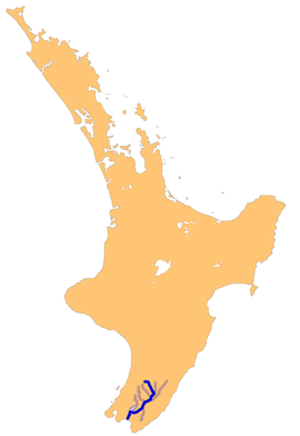
The Ruamahanga River system
Location
Country
New Zealand
Physical characteristics
Source
• location
Mount Dundas, Tararua Ranges
• elevation
1,504 m (4,934 ft)
Mouth
• location
Palliser Bay, Cook Strait
• elevation
0 m (0 ft)
Length
158 km (98 mi)
Basin size
3,470 km2 (1,340 sq mi)
Discharge
• average
81 m3/s (2,900 cu ft/s)[1]
Basin features
Tributaries
• left
Tauweru River
• right
Waipoua River, Waingawa River, Waiohine River, Lake Wairarapa outlet
The Ruamahanga River runs through the southeastern North Island of New Zealand.
The river's headwaters are in the Tararua Range northwest of Masterton. From there it runs firstly south and then southwest for 130 kilometres (81 mi) before emptying into the Cook Strait. The towns of Masterton and Martinborough are close to the banks of the river. It is joined by many other rivers, including the Tauweru River near Gladstone.[2]
In its lower reaches, the river meanders across a large floodplain, culminating in the wetlands around the edges of Lake Wairarapa. The river once flowed into the lake, but has now been diverted. The river drains at Palliser Bay 10 kilometres (6 mi) further south.
The river has now become generally polluted from sewage and farming that prevents people from swimming in the river or its tributaries.[3]
^NIWA Water & soil miscellaneous publication no. 48 (1983)
^Grant-Taylor, Thomas (1966). "RUAMAHANGA RIVER". Te Ara – 1966 Encyclopaedia of New Zealand. Retrieved 12 September 2018.
^Harris, Caleb (6 January 2016). "Some of Wairarapa's best swimming holes are now too dried up or polluted to swim in". The Dominion Post. Retrieved 28 June 2018.
The RuamahangaRiver runs through the southeastern North Island of New Zealand. The river's headwaters are in the Tararua Range northwest of Masterton...
(78 mi) RuamahangaRiver (NI) - 124 km (77 mi) Grey River or Mawhera River (SI) - 121 km (75 mi) Rangitata River (SI) - 120 km (74 mi) Tukituki River (NI)...
are located. The undulating hill country of the Wairarapa around the RuamahangaRiver, which becomes lower and flatter in the south and terminates in the...
The Waingawa River is a river of the Greater Wellington Region of New Zealand's North Island and a major tributary of the RuamahangaRiver. The name Waingawa...
Wairarapa and joins the RuamahangaRiver just north of the Gladstone Road bridge into Gladstone, southeast of Carterton. The river's name is Māori for "hanging...
winds. Inland from the bay is the plain of the RuamahangaRiver, which has its outflow in the bay. This river flows through Lake Wairarapa, 10 kilometres...
part of the RuamahangaRiver system Makara (disambiguation) This disambiguation page lists articles associated with the title Makara River. If an internal...
to reach the RuamahangaRiver close to the southern end of Lake Wairarapa. List of rivers of New Zealand "Place name detail: Tauanui River". New Zealand...
outflow into the RuamahangaRiver 5 kilometres (3 mi) north of Masterton. In December 2019, the approved official geographic name of the river was gazetted...
in 1901. It drained through settlement ponds and filter beds to the RuamahangaRiver south of the town. The sewage farm's system included a newfangled "septic...
Huangarua River is a river of the southern North Island of New Zealand. Rising in the foothills of the Aorangi Range it flows north to join the Ruamahanga River...
the Wellington Region. The district comprises the floodplain of the RuamahangaRiver and the associated Lake Wairarapa, as well as the long southern stretch...
Carterton and is the main tributary to the Waiohine River. The Waiohine flows into the RuamahangaRiver, southeast of Greytown. Eleven species of native...
plain where it passes to the north of Greytown and flows into the RuamahangaRiver at Pāpāwai. Its main tributary is the Mangatarere Stream. Some of its...
the Tongariro River. Full details of these pools, many of which are little more than widenings of the river or clear areas of the river's delta marshes...
Ruakākā River Ruakituri River Ruakokoputuna RiverRuamahangaRiver Rubicon River Ruera River Rum River Ryton River Sabine River Saxon River Saxton River Seaforth...
the Martinborough terrace, a raised alluvial terrace of the nearby RuamahangaRiver.[citation needed] Martinborough wineries are relatively small and typically...
discharge to the RuamahangaRiver. Almost half a million litres of partially and fully treated wastewater was discharged into the RuamahangaRiver in two incidents...
Awhea River Opouawe River Cape River Castle River Whawanui RiverRuamahangaRiver Kopuaranga River Waipoua River Whangaehu River Waingawa River Tauweru...
Wairarapa District of New Zealand's North Island. It is located near the RuamahangaRiver south-southeast of Carterton and north east of Greytown. Nearby smaller...
after and located on the middle reaches of the Tauweru River, which drains into the RuamahangaRiver near Gladstone and Te Whiti, and the name is a Māori-language...
 Global Information