The route from Londinium (London) to Aquae Sulis (Bath) comprised the road from Aquae Sulis to Calleva (Silchester), and then the Devil's Highway connecting Calleva to Londinium.
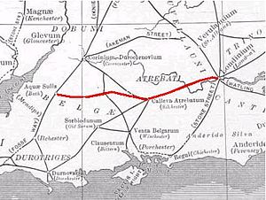
The Roman road from Silchester to Bath connected Calleva Atrebatum (Silchester) with Aquae Sulis (Bath) via Spinae (Speen), Cunetio (near Marlborough) and Verlucio (near Sandy Lane).[1] The road was a significant route for east–west travel and military logistics in south-east England during the 1st to 5th centuries.
Parts of its route were subsequently followed by earthworks that are presumed to form part of Wansdyke.[2] During the Middle Ages, the road was used by drovers, as well as by merchants and travellers.
Margary numbered the road as 53.[3] Portions of the Roman road are extant, while in other places all apparent vestiges are absent from view. In the early 19th century, Colt-Hoare surveyed and mapped its course from Overton Down (west of Marlborough) to Bath; the rest was only known in isolated sections until a study by Hugh Toller was published in 2013.[4]
^Linford, N T; Linford, P K; Payne, A W (February 2018). "Verlucio and Environs Project, Bowood Estate, Calne Without, Wiltshire: Report on Geophysical Surveys". Historic England. Retrieved 5 August 2018.
^Wansdyke Project description of the Roman road from London to Bath
^Margary, Ivan D. (1955). Roman Roads in Britain, Vol. 1. London: Phoenix House. pp. 124–126 – via Internet Archive.
^Toller, Hugh (2013). "The Roman road between Wickham (Speen), Berkshire and Fyfield, Wiltshire (Margary 53)". Wiltshire Archaeological and Natural History Magazine. 106: 52–65 – via Biodiversity Heritage Library.
and 22 Related for: Roman road from Silchester to Bath information
northern half of the modern parish, with the RomanroadfromSilchestertoBath as its northern boundary. A Roman villa (excavated in 1937 and 1971) was a...
Fosse Way King Street London-West of England RomanRoads Peddars Way Pye RoadRomanroadfromSilchestertoBath Stane Street (Chichester) Stane Street (Colchester)...
walled town in the Roman province of Britannia, at a major crossroads of the roads of southern Britain. The modern village of Silchester in Hampshire, England...
more than half that. Several unnamed roads were wider than Watling Street, such as the Silchesterto Chichester road at 11.2 m (37 ft). In the centre a...
number of these cities were settlements of Roman origin, the most famous of which is Aquae Sulis, modern day Bath. At least 26 of the current 63 cities in...
basilica at Silchesterto industrial uses in the late 3rd century, doubtless officially condoned, marks an early stage in the de-urbanisation of Roman Britain...
underground ammunition stores in the country. The Roman road from SilchestertoBath, and later earthworks which may be part of Wansdyke, run east–west...
list of cities and towns founded by the Romans. It lists cities established and built by the ancient Romansto have begun as a colony, often for the settlement...
days".: 272 The Romanroad continued along High Holborn and Oxford Street, via the Devil's Highway toSilchester and Bath: 31 To the north of the street...
all over the Roman Empire for minting. Silchester, Wroxeter, and Hengisbury Head were known locations for Roman cupellation remains. When inflation took...
access via the Devil's Highway toSilchester and Bath, and Watling Street to St Albans and the west midlands. These roads leading over the River Fleet....
one leading south from Cirencester towards Marlborough and the other south eastwards toSilchester (see Ermin Way). Evidence exists to show that Swindon's...
various roads. Seemingly based on official documents, possibly in part from a survey carried out under Augustus, it describes the roads of the Roman Empire...
Atrebatum (town ruins in the parish of Silchester) roads which passed through the district. East Bedfont Civil Parish (from 1930) Feltham Civil Parish (throughout)...
Romanroad which ran from Calleva Atrebatum (modern Silchester) north to Dorchester on Thames. Extrapolation of the known alignment fromSilchester to...
A partial list of Roman place names in Great Britain. This list includes only names documented fromRoman times. For a more complete list including later...
The Romanroad of Stane Street, connecting the city with London, started at the east gate, while the Chichester toSilchesterroad started from the north...
Burnett, A.; Henig, M.; Johns, C. (1989). "A Hoard of Late Roman Rings and Silver Coins fromSilchester, Hampshire". Britannia. 20: 219–228. doi:10.2307/526164...
 Global Information