This article is about the island in the Hauraki Gulf. For the islands in the Marlborough Sounds, see Rangitoto Islands. For the rural community in New Zealand's North Island, see Rangitoto, Waikato. For the mountain and range, see Rangitoto Range.
Rangitoto Island
Ngā Rangi-i-totongia-a Tama-te-kapua(Māori)
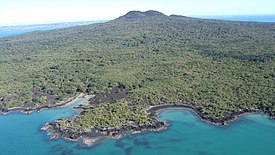
Oblique aerial of Rangitoto Volcano from the south
Rangitoto Island is a volcanic island in the Hauraki Gulf near Auckland, New Zealand. The 5.5 km (3.4 mi) wide island is a symmetrical shield volcano cone capped by central scoria cones, reaching a height of 260 m (850 ft).[2][3] Rangitoto is the youngest and largest of the approximately 50 volcanoes of the Auckland volcanic field, having erupted in two phases about 1450 CE and 1500 CE [4][5] and covering an area of 2,311 ha (5,710 acres).[3][6] It is separated from the mainland of Auckland's North Shore by the Rangitoto Channel. Since World War II, it has been linked by a causeway to the much older, non-volcanic Motutapu Island.[7]
Rangitoto is Māori for 'Bloody Sky',[8] with the name coming from the full phrase Ngā Rangi-i-totongia-a Tama-te-kapua ("The days of the bleeding of Tama-te-kapua"). Tama-te-kapua was the captain of the Arawawaka (canoe) and was badly wounded on the island, after having lost a battle with the Tainuiiwi (tribe) at Islington Bay.[6][9][10]
^Cite error: The named reference NcGee2020 was invoked but never defined (see the help page).
^"Auckland Volcanic Field: Photo Gallery". Global Volcanism Program. Smithsonian Institution. Retrieved 21 June 2008.
^ ab"Auckland Field". Global Volcanism Program. Smithsonian Institution. Retrieved 29 April 2009.
^Luthfian, Alutsyah; Eccles, Jennifer D.; Miller, Craig A. (2023). "Gravity and magnetic models at Rangitoto Volcano, Auckland Volcanic Field, New Zealand: Implications for basement control on magma ascent". Journal of Volcanology and Geothermal Research. 439 (107824). doi:10.1016/j.jvolgeores.2023.107824. hdl:2292/65385. ISSN 0377-0273.
^Devora (2020). Rangitoto: Odd one out. The story of Auckland's largest volcano. Devora Fact Sheet 03."DEVORA Fact Sheet 3 - Rangitoto: Odd One Out". Retrieved 3 March 2023.
^ abCite error: The named reference ACC was invoked but never defined (see the help page).
^Ottaway, Jacqueline Crompton (30 April 2004). "Rangitoto – Auckland's Fragile Icon". NZine. Retrieved 26 April 2010.
^What happened to local Maori? Archived 5 October 2003 at the Wayback Machine (from the Rangitoto page on the GNS Science website)
^Rangitoto Archived 20 May 2008 at the Wayback Machine (from the Auckland Regional Council website)
^Rangitoto (abridged article from New Zealand National Geographic)
RangitotoIsland is a volcanic island in the Hauraki Gulf near Auckland, New Zealand. The 5.5 km (3.4 mi) wide island is a symmetrical shield volcano...
eastern side of the school have a view of the Rangitoto Channel as well as RangitotoIsland. Rangitoto College opened in 1956, with an initial roll of...
Hauraki Gulf islands of Motutapu Island and RangitotoIsland are connected at low tide The Okatakata Islands in Rangaunu Harbour Islands portal Islet...
The RangitotoIslands are a group of islands near the Marlborough Sounds along the northern coast of the South Island of New Zealand. The group consists...
to the much younger volcanic island cone of Rangitoto. Prior to the emergence of the volcano, the island had been extensively occupied by Māori for over...
obelisk. RangitotoIsland – an island which guards the entrance to Waitematā Harbour and forms a prominent feature on the eastern horizon. The island was formed...
The Rangitoto Channel is an area of the Hauraki Gulf in the Auckland Region of New Zealand's North Island. The channel is north-east of the Waitematā...
volcanism in the central North Island, such as at Mount Ruapehu and Lake Taupō. The field ranges from Lake Pupuke and RangitotoIsland in the north to Matukutururu...
at least 40 volcanoes, most recently active about 600 years ago at RangitotoIsland, erupting 2.3 km3 (0.55 cu mi) of lava. The soils of the Pacific Ring...
Ian E.M. Smith, and Simon Nathan. () New Zealand's volcanoes: Kermadec Islands Archived 2010-05-22 at the Wayback Machine. Volcanic Hazards Working Group...
to 1952. Some monogenetic volcanoes are small lava shields, such as RangitotoIsland in the Auckland volcanic field. Other monogenetic volcanoes are tuff...
Island were likely heavily damaged in the 14th century eruptions of RangitotoIsland. During 18th and early 19th centuries, the eastern side of Waiheke...
crest features an A in its centre to symbolise the city, representing RangitotoIsland and the Sky Tower. The black knight visor and stripes represent the...
be efficient in the colonisation of lava plains – notably on Rangitoto, a volcanic island in the Hauraki Gulf. A giant pōhutukawa at Te Araroa on the East...
by one. She is also said to have played a role in the formation of RangitotoIsland, asking Rūaumoko, god of earthquakes and eruptions, to destroy a couple...
Browns Island, Motuihe Island, Pakihi Island, Pakatoa Island, Rakino Island, and Rotoroa Island in the inner gulf, around Waiheke and Rangitoto; Tarahiki...
This is a list of islands in the world ordered by their highest point; it lists islands with peaks by elevation. At the end of this article continental...
Cytology of Psilotum with Special Reference to Vascular Prothalli from RangitotoIsland". Annals of Botany. 6 (2): 283–292. doi:10.1093/oxfordjournals.aob...
debris to the surface regolith. An example of this is the island of Surtsey, which is an island formed in 1963 after a volcanic eruption from beneath the...
Menengai La Grille (Comoros) Queen Mary's Peak (South Atlantic Ocean) RangitotoIsland (New Zealand) Santorini (Greece) São Tomé (São Tomé and Príncipe, Atlantic...
craters, scoria cones, and lava flows. The largest and most recent is Rangitoto in the Hauraki Gulf, which last erupted 600–700 years ago. Currently dormant...
 Global Information