Active and passive means of determining position via radio waves
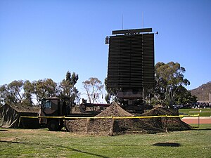
RAAF AN-FPS-117 radar in 2007
As defined by FS-1037C and ITU Radio Regulations, radiodetermination is:[1]
the determination of the position, velocity or other characteristics of an object, or the obtaining of information relating to these parameters, by means of the propagation properties of radio waves
There are two main fields to radiodetermination:[1]
radionavigation: "used for the purposes of navigation, including obstruction warning", which is mainly active;
radiolocation: "used for purposes other than those of radionavigation", which is mainly passive.
Radar is a radiodetermination system based on the reflection (or retransmission) of a radio wave by an object at a position to be determined.[1]
^ abcITU (2020). "Chapter I – Terminology and technical characteristics" (PDF). Radio Regulations. International Telecommunications Union (ITU). Retrieved 2024-03-24.
and 13 Related for: Radiodetermination information
As defined by FS-1037C and ITU Radio Regulations, radiodetermination is: the determination of the position, velocity or other characteristics of an object...
rather than actively finding one's own position; both are types of radiodetermination. Radiolocation is also used in real-time locating systems (RTLS) for...
the vessel or an obstruction. Like radiolocation, it is a type of radiodetermination. The basic principles are measurements from/to electric beacons, especially...
angles), and radial velocity of objects relative to the site. It is a radiodetermination method used to detect and track aircraft, ships, spacecraft, guided...
Telecommunication Union's (ITU) ITU Radio Regulations (RR), defined as: A radiodetermination system based on the comparison of reference signals with radio signals...
requirements described in EN 301 893 to ensure compatible operation with radiodetermination systems (radars). Such mitigation techniques shall equalise the probability...
transformative, diverse, singular scientific and public service contributions. Radiodetermination Satellite Services and Standards, Artech House, 1987, ISBN 0-89006-239-0...
additional MEMS based Inertial Navigation System (INS) along with radiodetermination-satellite service GPS/NAVIC. With a range of about 1000 km, Nirbhay...
orbit/spectrum utilization for the mobile-satellite service (MSS) and the radiodetermination-satellite service (RDSS) Study Group 5 – Terrestrial services 5A:...
 Global Information