The Qualicum National Wildlife Area (NWA) was officially established in 1977,[2] under the Canada Wildlife Act (1973).[3] The primary objective of the Qualicum NWA was to conserve crucial habitats for migratory birds and various other species.[3]
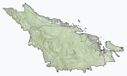
The national wildlife area consists of three small units - Rosewall Creek, Marshall-Stevenson, and Nanoose Bay - spread out along the northeastern coast Vancouver Island between the communities of Fanny Bay and Nanoose Bay.
Since it is a National Wildlife Area (NWA), Qualicum NWA is governed by the Canada Wildlife Act[2] and managed by the Canadian government department Environment and Climate Change Canada.[2] While most National Wildlife Areas are closed to the public to reduce the human impacts on the land, vegetation, animals, and insects, the Qualicum NWA is open for certain recreational activities, such as wildlife viewing and hiking[2] as well as hunting in certain areas.[4]
^"Qualicum National Wildlife Area". Protected Planet. Retrieved 15 September 2020.
^ abcdCanada, Environment and Climate Change (25 November 2011). "Qualicum National Wildlife Area". www.canada.ca. Retrieved 11 October 2023.
^ ab"BC Geographical Names". apps.gov.bc.ca. Retrieved 11 October 2023.
^Canada, Environment and Climate Change (20 February 2015). "Qualicum National Wildlife Area pamphlet". www.canada.ca. Retrieved 11 October 2023.
and 24 Related for: Qualicum National Wildlife Area information
within the traditional territory of the Qualicum First Nation. People from all over would come to the Qualicumarea to gather camas flowers in the spring...
The Alaksen NationalWildlifeArea is located on Westham Island in the city of Delta, British Columbia. It is an important stopover point for many species...
Park Little Qualicum Falls Provincial Park MacMillan Provincial Park Mount Arrowsmith Massif Regional Park QualicumNationalWildlifeArea Rathtrevor Beach...
Park Twin Falls Tea House Six NationalWildlifeAreas of Canada are located in British Columbia: Alaksen Columbia Qualicum Scott Islands Marine Vaseux-Bighorn...
NationalWildlifeArea was established to protect its wetlands and as a temporary home for migratory birds travelling to South America. The National Wildlife...
Lowest % of the population 15-64: Qualicum Beach, British Columbia, 36.9% Highest % of the population 65+: Qualicum Beach, British Columbia, 56.3% Lowest %...
Little Qualicum Falls Provincial Park is a provincial park in British Columbia, Canada, on central Vancouver Island, that encompasses the entire southern...
many villages which line the coast such as Cowichan Bay, Chemainus, and Qualicum Beach. Consumer food products companies also exist in the various cities...
tallest well-documented individual is called Whisky Creek Cedar II in Qualicum Beach, on Vancouver Island. It stands 63 m (206 ft) in height, although...
Hatley Park National Historic Site is located in Colwood, British Columbia, in Greater Victoria. It is the site of Hatley Castle, a Classified Federal...
Scott Islands Marine NationalWildlifeArea is a NationalWildlifeArea off the northwestern tip of Vancouver Island in the Canadian province of British...
Todagin Wildlife Management Area is a wildlife management area located southeast of Iskut in northwestern British Columbia. It was established by the British...
Pleistocene colony?" (PDF). Ghent University. Harington CR, Beard G (1992). "The Qualicum walrus: a Late Pleistocene walrus (Odobenus rosmarus) skeleton from Vancouver...
The Cascade Recreation Area was a Provincial Recreation Area in the Hozameen Range of the Cascade Mountains of British Columbia, Canada, located north...
Yoho National Park (/ˈjoʊhoʊ/ YOH-hoh) is a national park of Canada. It is located within the Rocky Mountains along the western slope of the Continental...
Gwaii Haanas National Park Reserve, National Marine Conservation Area, and Haida Heritage Site, usually referred to simply as Gwaii Haanas (/ˌɡwaɪ ˈhɑːnəs/)...
The Mount Edziza Recreation Area was a recreation area in Cassiar Land District of northwestern British Columbia, Canada, located southeast of the community...
S2CID 130124047. D.M. Poll and M.M. Porter (1984). "Wildlife". Ecological Land Classification of Kootenay National Park, British Columbia. Vol. I: Integrated Resource...
Vancouver Island. There were stories that the natives used a trail starting at Qualicum. Adam Horne found this trail leading to the Alberni Valley and it became...
Conservancy is a conservancy in Haida Gwaii, British Columbia, Canada. The total area is 7,970 hectares (19,700 acres). It covers Yakoun Lake and its watershed...
 Global Information