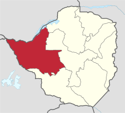
Matabeleland North is a province in western Zimbabwe. With a population of 827,645 as of the 2022 census,[2] it is the country's second-least populous province, after Matabeleland South, and is the country's least densely populated province. Matabeleland North and Matabeleland South were established in 1974, when the original Matabeleland Province was bifurcated.[3] In 1997, the province lost territory when the city of Bulawayo became a province in its own right. Matabeleland North is divided into seven districts. Its capital is Lupane, and Victoria Falls and Hwange its largest towns. The name "Matabeleland" is derived from the Matabele or Ndebele people, the province's largest ethnic group.
Matabeleland North is bordered by Matabeleland South and Bulawayo to the south, Midlands to the east, Mashonaland West to the northeast, Botswana to the west, and Zambia to the north, which is separated from Zimbabwe by the Zambezi river. It has an area of 75,025 square kilometres (28,967 sq mi), amounting to 19.2% of the total area of Zimbabwe. In terms of area, It is the largest the country's ten provinces. Matabeleland North is located on the edge of the Kalahari Basin, giving it an arid climate. Its economy is dominated by agriculture, with 83% of employed people in the province working as farmers.[4] Cattle ranching and tourism also contribute to the economy. The Zimbabwean side of Victoria Falls, a World Heritage Site and major tourist attraction, is located in Matabeleland North.
^"Sub-national HDI - Area Database - Global Data Lab". hdi.globaldatalab.org. Retrieved 13 September 2018.
^"Zimbabwe: Administrative Division (Provinces and Districts) - Population Statistics, Charts and Map". www.citypopulation.de. Retrieved 17 February 2024.
^"Zimbabwe Provinces". www.statoids.com. Retrieved 19 May 2021.
^Zwinoira, Tatira (16 January 2018). "Harare, Byo has lowest economic activity rate". NewsDay Zimbabwe. Retrieved 26 June 2018.
and 27 Related for: Matabeleland North Province information
second-least populous province, after Matabeleland South, and is the country's least densely populated province. MatabelelandNorth and Matabeleland South were established...
populous province. After MatabelelandNorth, it is Zimbabwe's second-least densely populated province. Matabeleland South and MatabelelandNorth were established...
of them. MatabelelandNorthProvince has thirteen constituencies and 197 wards. There are ten local authorities in MatabelelandNorthProvince, wards are...
Beitbridge Bulilima Gwanda Insiza Mangwe Matobo Umzingwane Chirumhanzu Gokwe North Gokwe South Gweru Kwekwe Mberengwa Shurugwi Zvishavane Provinces of Zimbabwe...
Josiah Gumede was born in Bembesi, in the Bubi District (now in MatabelelandNorth) of Southern Rhodesia. He was educated at the David Livingstone Memorial...
The Matabeleland Zambezi Water Project (MZWP) is an ambitious project being undertaken in the arid MatabelelandNorthprovince of Zimbabwe.The project...
sheet of falling water. The Victoria Falls are roughly twice the height of North America's Niagara Falls and well over twice its width. For a considerable...
in Zimbabwe. Schools 'highfied' are listed alphabetically by Zimbabwean province and then by Zimbabwean district and then by further subdivision (i.e.,...
district in MatabelelandNorthprovince in Zimbabwe. Its administrative centre is at Tsholotsho business centre which is located about 98 km north-west of...
Umguza is a district in the southern part of MatabelelandNorthprovince in Zimbabwe. It was formerly known as Esiphezini District. Umguza District is...
mines in Zimbabwe. The mine is located in western Zimbabwe in MatabelelandNorthProvince. The Kamativi mine has reserves amounting to 100 million tonnes...
Ndabaningi Sithole (21 July 1920 – 12 December 2000) was the founder of the Zimbabwe African National Union (ZANU), a militant, nationalist organisation...
part of North West in South Africa, the Central and North-East Districts of Botswana and the Matabeleland South and part of MatabelelandNorth provinces...
kilometres (25 mi) north. Rivers such as the Mcheni and Lwizikululu have cut almost sheer gorges in the escarpment. At the north eastern extremity of...
Zambezi National Park is a national park in Zimbabwe located upstream from Victoria Falls on the Zambezi River. It was split off from Victoria Falls National...
Bumbusi is a Zimbabwean archaeological site, surrounded by Hwange National Park, in Western Zimbabwe. It is not often visited because of its remote location...
Victoria Falls National Park in north-western Zimbabwe protects the south and east bank of the Zambezi River in the area of the world-famous Victoria...
Lozikeyi Dlodlo (c. 1855-1919) was a queen regent of the Ndebele people in Southern Africa. Lozikeyi was one of the favourite wives of Lobengula, and a...
Tsholotsho High School is a co-educational, secondary school that is located in Tsholotsho 113 km south west of Zimbabwe's second largest city, Bulawayo...
Park is situated in Zimbabwe's extreme north-western corner, lying on the Botswana border a short distance north-west of Hwange National Park. Some 77...
Bright Vanya Moyo is a Zimbabwean politician who served as the Member of Parliament for Lupane East between September and October 2023 as a member of the...
a village on the south eastern shore of Lake Kariba in the province of MatabelelandNorth, Zimbabwe. Binga was built to rehouse the BaTonga people whose...
Bembezi is a small town in MatabelelandNorth, Zimbabwe and is located about 43 km north-east of Bulawayo. The Battle of Bembezi took place nearby on...
Chirumbira of the Masvingo Province is the current council president, and Chief Lucas Mtshane Khumalo of MatabelelandNorthProvince is his deputy. Due to...
Wankie, is a town in Zimbabwe, located in Hwange District, in MatabelelandNorthProvince, in northwestern Zimbabwe, close to the international borders...
Lupane ( luːpɑːnɛ) District is located in the MatabelelandNorthProvince of Zimbabwe, and it is also the Provincial Capital. The District is situated...
 Global Information