"Pocomoke" redirects here. For other uses, see Pocomoke (disambiguation).
River in & Virginia, United States
Pocomoke River
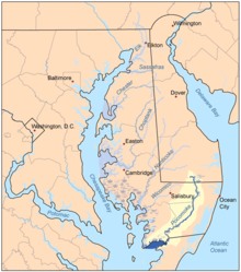
Map of the rivers of the Eastern Shore of Maryland with the Pocomoke and its watershed highlighted.
Location
Country
United States
State
Delaware, Maryland, & Virginia
Region
Delmarva Peninsula
Physical characteristics
Source
Great Cypress Swamp
Mouth
Pocomoke Sound
• elevation
0 ft (0 m)
Length
66 mi (106 km), northeast-to-southwest
Basin features
Tributaries
• left
Dividing Creek, Nassawango Creek, Givens Branch, Aydelotte Branch
• right
Pitts Creek, Pilchard Creek, Mattaponi Creek, Corkers Creek
The Pocomoke River stretches approximately 66 miles (106 km)[1] from southern Delaware through southeastern Maryland in the United States. At its mouth, the river is essentially an arm of Chesapeake Bay, whereas the upper river flows through a series of relatively inaccessible wetlands called the Great Cypress Swamp, largely populated by Loblolly Pine, Red Maple and Bald Cypress. The river is the easternmost river that flows into Chesapeake Bay.
"Pocomoke" locally /ˈpoʊkoʊmoʊk/, though traditionally interpreted as "dark (or black) water" by local residents, is now agreed by scholars of the Algonquian languages to be derived from the words for "broken (or pierced) ground."[2]
^U.S. Geological Survey. National Hydrography Dataset high-resolution flowline data. The National Map Archived 2012-03-29 at the Wayback Machine, accessed April 1, 2011
^Nestor, Sandy (2004). Indian Placenames in America. McFarland. p. 80. ISBN 9780786493395. Archived from the original on 21 February 2017. Retrieved 20 February 2017.
The PocomokeRiver stretches approximately 66 miles (106 km) from southern Delaware through southeastern Maryland in the United States. At its mouth, the...
Pocomoke State Forest is a state forest of Maryland that lies on both banks of the PocomokeRiver in Worcester County. The portion north of the Pocomoke...
The Great Cypress Swamp (also known as Burnt Swamp, Great Pocomoke Swamp, Cypress Swamp, or Big Cypress Swamp), is a forested freshwater swamp located...
PocomokeRiver State Park is a public recreation area lying on both banks of the PocomokeRiver between Snow Hill and Pocomoke City in Worcester County...
Peace River: located in central Florida, flows into Charlotte Harbor. Pithlachascotee River: a small river in central Florida PocomokeRiver: a river in...
Christina River Ayres Creek Greys Creek St. Martin River Turville Creek Trappe Creek PocomokeRiver Dividing Creek Nassawango Creek Little Annemessex River Big...
Pocomoke Sound is a bay of the Chesapeake Bay that forms part of the boundary between the Eastern Shores of Maryland and Virginia. The PocomokeRiver...
consists of an earth and rock wall dam across a tributary of the Youghiogheny River. Construction of the dam began in 1923 and was completed in 1925. The hydroelectric...
rivers drain directly into the Chesapeake Bay: PocomokeRiver Little Annemessex River Big Annemessex River Manokin River Monie Creek Wicomico River (Maryland...
Rappahannock River York River Patuxent River Choptank River For more information on Chesapeake Bay rivers, see the List of Chesapeake Bay rivers. The Chesapeake...
Machipongo RiverPocomokeRiver Potomac River Hull Creek Coan River Yeocomico River Northwest Yeocomico River South Yeocomico River West Yeocomico River Lower...
Myrtle Grove Nanjemoy Nanjemoy Creek Nanticoke River Old Bohemia Parker's Creek PocomokeRiverPocomoke Sound Prather's Neck Ridenour Swamp Riverside Sideling...
Deep Creek Lake reservoir was created on a tributary of the Youghiogheny River with completion of the Deep Creek Dam by the Pennsylvania Electric Company...
area, situated on fields among the Appalachian foothills near the Potomac River, features the battlefield site and visitor center, a national military cemetery...
Myrtle Grove Nanjemoy Nanjemoy Creek Nanticoke River Old Bohemia Parker's Creek PocomokeRiverPocomoke Sound Prather's Neck Ridenour Swamp Riverside Sideling...
1963 Patuxent River Hunting, fishing, hiking and horseback riding. PocomokeRiver State Park Worcester 916 acres 371 ha 1939 PocomokeRiver Visitors center...
Oppoquimimi River Patapsco River Patuxent River Piscataway Creek Piscataway Park Piscataway, Maryland Pocomoke City, Maryland PocomokeRiverPocomoke Sound...
Myrtle Grove Nanjemoy Nanjemoy Creek Nanticoke River Old Bohemia Parker's Creek PocomokeRiverPocomoke Sound Prather's Neck Ridenour Swamp Riverside Sideling...
north side and the Middle and Ferry (now Southern) branches of the Patapsco River on the south side. The Frenchman Jean Foncin designed the fort in 1798,...
13 (US 13) in West Pocomoke north to Pocomoke State Forest. MD 364 parallels the PocomokeRiver and provides access to PocomokeRiver State Park. The state...
the area, overlooking the confluence of the Potomac River, Patuxent River and the St. Mary's River, along with its key vantage point on the Chesapeake...
 Global Information