Website U.S. Army Corps of Engineers - Pine Flat Lake Project
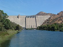
Pine Flat Dam is a concrete gravity dam on the Kings River in the Central Valley of Fresno County, California United States. Situated about 28 miles (45 km) east of Fresno, the dam is 440 feet (130 m) high and impounds Pine Flat Lake, in the foothills of the Sierra Nevada just outside the boundary of Kings Canyon National Park. The dam's primary purpose is flood control, with irrigation, hydroelectric power generation and recreation secondary in importance.
The dam was built by the U.S. Army Corps of Engineers (USACE) after a six-year controversy between supporters of irrigation development and proponents of flood control. Construction began in 1947 and was completed in 1954. Since then, the dam has prevented millions of dollars in flood damages and fostered extensive development of agriculture on the fertile floodplain of the Kings River; after 1984 it has also generated hydroelectricity. The increased irrigation allowed by the dam has also led to the destruction of some of North America's most extensive wetland habitats.
^ abc"Pine Flat Dam: Detailed Information". National Inventory of Dams. U.S. Army Corps of Engineers. Retrieved April 1, 2012.
^ abc"Pine Flat Dam (PNF)". California Data Exchange Center. California Department of Water Resources. Retrieved April 1, 2012.
^Ritzema, Randall S.; Newlin, Brad D.; Van Lienden, Brian J. (October 2001). "Appendix H: Infrastructure" (PDF). CALVIN Project. University of California Davis. Archived from the original (PDF) on November 6, 2017. Retrieved January 25, 2014.
^"Pine Flat Lake". Geographic Names Information System. United States Geological Survey, United States Department of the Interior. August 1, 1990. Retrieved April 1, 2012.
^"Pine Flat Power Plant". Kings River Conservation District. Retrieved April 1, 2012.
^"California Hydroelectric Statistics & Data". California Energy Commission. Archived from the original on February 26, 2018. Retrieved April 26, 2018.
PineFlatDam is a concrete gravity dam on the Kings River in the Central Valley of Fresno County, California United States. Situated about 28 miles (45 km)...
PineFlat may refer to: PineFlat, California, in Tulare County PineFlatDamPineFlat Lake This disambiguation page lists articles about distinct geographical...
boaters, campers & hikers. The lake was formed by the construction of PineFlatDam on the Kings River in 1954 by the U.S. Army Corps of Engineers, and...
tallest dams in the United States. The main list includes all U.S. dams over 300 feet (91 m) tall, and a second list gives the tallest dams in each state...
construction of the Terminus and Success Dams on the Kaweah and Tule Rivers in Tulare County and PineFlatDam on the Kings River in Fresno County. Although...
2012-05-13. "Dam & River Basin". U.S. Army Corps of Engineers. 2011-07-07. Archived from the original on 2012-04-22. Retrieved 2012-05-05. "PineFlatDam (PNF)"...
nearly double the storage capacity on the Kings River, as the existing PineFlatDam is unable to provide the high degree of flood protection for which it...
Scotts FlatDam dates from 1948 and impounds Deer Creek to create the reservoir with a capacity of 49,000 acre-feet. At 175 feet above streambed, the dam is...
earthquake Ah Pah Dam (defunct) Auburn Dam (defunct) Centennial Dam Sites Reservoir Temperance FlatDam California State Water Project List of dam removals in...
River falls more than 13,000 feet (4,000 m) from the Sierra crest to PineFlat Reservoir in the San Joaquin Valley – the longest undammed drop of any...
www.eia.gov. Retrieved February 18, 2020. "Electricity Data Browser - PineFlat". www.eia.gov. Retrieved February 19, 2020. "Electricity Data Browser...
the largest of these is Lake Shasta, which formed behind Shasta Dam in the 1940s. The dam can impound 4.552 million acre⋅ft (1.483 trillion US gal; 5.615 trillion L)...
November 19, 2019. Baker, George (April 21, 1977). "A Capital Laugh - PineFlatsDam For Sale?". Fresno Bee. "Keene backs Peripheral Canal". No. 50. Healdsburg...
reached the height of the lava dam. These sediments form the floor of the present day Pine Valley, Grass Valley, and Grassy Flat. The mountains straddle the...
establishment of the Kings River Conservation District and power generation at PineFlatDam as well as the taxation of cities that may encroach into the district...
New Melones Dam is an earth and rock filled embankment dam on the Stanislaus River, about 5 miles (8.0 km) west of Jamestown, California, United States...
River. There are records of Chinook salmon presence 10–12 miles above PineFlat, possibly including the South Fork, before the 1940s. Woodhull and Dill...
 Global Information