Pico do Fogo (Portuguese:[ˈpikuduˈfoɡu]; lit.'Peak of Fire') is an active stratovolcano located on the island of Fogo, Cape Verde, rising to 2,829 metres (9,281 ft) above sea level.[2] The main cone last erupted in 1680, causing mass emigration from the island.[3] A subsidiary vent erupted in 1995. The only deadly eruption was in 1847 when earthquakes killed several people.
Fogo, which means "fire" in Portuguese, is a hotspot volcanic island.[4] Its most recent eruptions occurred in 1951, 1995 and 2014. It is the youngest and most active volcano in the Cape Verde Islands, a short chain of volcanic islands that generally are younger at the western end, formed as the African Plate moved towards the east over the hotspot.[5]
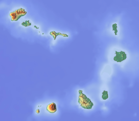
Fogo consists of a single volcano, so the island is nearly round and about 25 kilometers (16 mi) in diameter.[6] The large summit caldera (about 10 kilometers in the north–south direction and 7 kilometers in the east–west direction) is not located in the center of the island, but rather towards its northeastern corner. The caldera is bounded by steep near-vertical fault scarps on the north, west, and south sides but is breached to the east where lava can flow to the coast.[7] North-northeast-trending eruptive fissures opened along the western flank of Pico, which formed inside the caldera between about 1500 and 1760.[5] The last eruption from the top was in 1769. The current topography of Fogo, with the caldera open to the sea on the east side, results from the sliding of the east flank of the volcano towards the ocean.[5]
The mountain's slopes are used to grow coffee, while its lava is used as building material.[citation needed] Near its peak is a caldera and a small village, Chã das Caldeiras, is inside this caldera. The crater rim, which reaches 2,700 m elevation, is known as Bordeira.
^ ab"Fogo". Global Volcanism Program. Smithsonian Institution. Retrieved 2018-10-11.
^ abCabo Verde, Statistical Yearbook 2015, Instituto Nacional de Estatística, p. 25
^Cite error: The named reference jenkins was invoked but never defined (see the help page).
^Carracedo, Juan Carlos; Troll, Valentin R. (2021-01-01). "North-East Atlantic Islands: The Macaronesian Archipelagos". Encyclopedia of Geology. pp. 674–699. doi:10.1016/B978-0-08-102908-4.00027-8. ISBN 9780081029091. S2CID 226588940.
^ abcCite error: The named reference hvo_1995 was invoked but never defined (see the help page).
^Carracedo, Juan-Carlos; Perez-Torrado, Francisco J.; Rodriguez-Gonzalez, Alejandro; Paris, Raphaël; Troll, Valentin R.; Barker, Abigail K. (July 2015). "Volcanic and structural evolution of Pico do Fogo, Cape Verde". Geology Today. 31 (4): 146–152. Bibcode:2015GeolT..31..146C. doi:10.1111/gto.12101. S2CID 128995452.
^Carracedo, Juan-Carlos; Perez-Torrado, Francisco J.; Rodriguez-Gonzalez, Alejandro; Paris, Raphaël; Troll, Valentin R.; Barker, Abigail K. (2015). "Volcanic and structural evolution of Pico do Fogo, Cape Verde". Geology Today. 31 (4): 146–152. Bibcode:2015GeolT..31..146C. doi:10.1111/gto.12101. ISSN 1365-2451. S2CID 128995452.
PicodoFogo (Portuguese: [ˈpiku du ˈfoɡu]; lit. 'Peak of Fire') is an active stratovolcano located on the island of Fogo, Cape Verde, rising to 2,829...
Lagoa doFogo (Lake of Fire) is a crater lake within the Água de Pau Massif stratovolcano in the center of the island of São Miguel in the Portuguese...
region of 1200 km2 (460 sq mi), associated with a rise of the geoid. PicodoFogo, the largest active volcano in the region, erupted in 2014. It has an...
tallest volcanic peak of Madeira, Pico Ruivo A cloud layer around Pico das Torres Looking towards the summit of Picodo Arieiro Geology of Madeira Sources...
point; hence most are not included below. Some well-known peaks listed here do not score highly by prominence. All peaks with a prominence of more than 1...
park is situated in the interior of the island, and covers the volcano PicodoFogo, its crater and crater rim (Bordeira) and the forest of Monte Velha....
Mount Pico (Portuguese: Montanha doPico) is a currently dormant stratovolcano located on Pico Island, in the mid-Atlantic archipelago of the Azores. It...
the lowest hardiness zone is found in the island of Fogo, in the country's highest peak PicodoFogo.[citation needed] In addition to the USDA Hardiness...
1682, was succeeded by the Company of Cacheu and Cape Verde in 1690. PicodoFogo erupted in 1680, which resulted in the movement of the population to...
to Praia in 1770. The eruption of the volcano PicodoFogo in 1680 covered much of the island of Fogo in ash, which forced many inhabitants to flee to...
Miguel, almost simultaneous with the eruption on Lagoa doFogo, caused a strombolian eruption in Picodo Sapateiro parish of Ribeira Seca. The peak was a dome...
runner up withdrew, it was canceled in 2014 and 2015, the time when PicodoFogo on the nearby island to the west was erupting, it delayed the regional...
New Mexico at 1347 m on the Continental Divide. Its encirclement parent is Pico de Orizaba (5,636 m), the highest mountain in Mexico. Orizaba's key col is...
Torre, Santo Antão Fogo Natural Park Monte Gordo, São Nicolau Monte Verde, São Vicente Moroços, Santo Antão Norte, Boa Vista Serra doPico de Antónia, Santiago...
both in the houses of São Filipe and on the cliff walls of the volcano PicodoFogo. The Spanish sparrow is strongly gregarious, flocking and breeding in...
third-lowest depression on Earth. It has yet to be determined whether Pico Cristóbal Colón or Pico Simón Bolívar is the highest point of the Sierra Nevada de Santa...
PicodoFogo. The 2016 cup competition took place, the 2016 final did not take place. Source: Sports in Fogo, Cape Verde Fogo Premier Division Fogo Island...
líbrame deste fogo airado, pola intercesión de la Virgen María, un Padre-nuestro e un Ave María. Ou, simplemente: "Pico Sagro, Pico Sagro, sáname do mal que...
as the seat of Santa Catarina doFogo Municipality. Its elevation is 480 meters above sea level. The volcano PicodoFogo is 7.7 km to the northwest. Nearby...
 Global Information