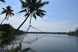
Periyar, IPA:[peɾijɐːr], (meaning: big river) is the longest river and the river with the largest discharge potential in the Indian state of Kerala.[3] It is one of the few perennial rivers in the region and provides drinking water for several major towns.[4] The Periyar is of utmost significance to the economy of Kerala. It generates a significant proportion of Kerala's electrical power via the Idukki Dam and flows along a region of industrial and commercial activity. The river also provides water for irrigation and domestic use throughout its course besides supporting a rich fishery.[5][6] Due to these reasons, the river has been named the "Lifeline of Kerala".[7] Kochi city, in the vicinity of the river mouth, draws its water supply from Aluva, an upstream site sufficiently free of seawater intrusion. Twenty five percent of Kerala's industries are along the banks of the Periyar. These are mostly crowded within a stretch of 5 kilometres (3 mi) in the Eloor-Edayar region (Udhyogamandal), about 10 kilometres (6 mi) north of Kochi harbor.[6]
^James Wilson (13 August 2018). "Understanding the 42-year-old Idukki dam which is now saving Kerala". The Print. Retrieved 8 September 2020.
^"UNEP GEMS/Water Programme" (PDF). Retrieved 27 February 2014.
^"Study area and methods" (PDF). India. p. 7. Retrieved 31 October 2012.
^"Idukki District Hydroelectric projects". Retrieved 12 March 2007.
^"Salient Features – Dam". Retrieved 12 March 2007.
^ ab"Growth response of phytoplankton exposed to industrial effluents in River Periyar" (PDF). CUSAT. Retrieved 4 March 2014.
^"Periyar". ENVIS Centre: Kerala. Retrieved 16 August 2019.
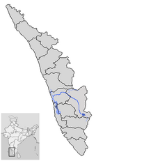
Periyar, IPA: [peɾijɐːr], (meaning: big river) is the longest river and the river with the largest discharge potential in the Indian state of Kerala....
flora and fauna and forms the major watershed of two important rivers of Kerala: the Periyar and the Pamba. The park is located high in the Cardamom Hills...
Mullaperiyar Dam (IPA: [mulːɐpːeɾijɐːr]) is a masonry gravity dam on the PeriyarRiver of Idukki district of Indian state of Kerala. It is situated 150km south...
Theni, Madurai and Ramanathapuram. It originates in Varusanadu Hills, the Periyar Plateau of the Western Ghats range, and flows northeast through the Kambam...
by the Mullaperiyar Dam across the PeriyarRiver adds to the charm of the park. The greatest attractions of Periyar are the herds of wild elephants, deer...
Penna River Pench River Penganga River Penner RiverPeriyarRiver Phalgu Pluest River (Poonch J&K) Ponnaiyar River Pranhita River Punarbhaba River Purna...
situated around 15 km (9.3 mi) from the city centre on the banks of PeriyarRiver. A major transportation hub, with easy access to all major forms of...
name of the port, "Muciri" (Malayalam: മുചിറി). In the region, the Periyarriver perhaps branched into two like a cleft lip, thus speculatively leading...
Muthirapuzha River is one of the major tributaries of the PeriyarRiver, the longest river in Kerala state south India. It begins in remote forests above...
Three dams - Munnar Headworks Dam, Lower Periyar Dam, and Maniyar Dam - have no drainage area across the river. The Idukki Dam and Idamalayar Dams hold...
Mullayar River is a tributary of the PeriyarRiver, the longest river in Kerala. It originates at Kottamalai peak in the Periyar Tiger Reserve. The Mullayar...
The Idukki Dam is a double-curvature arch dam constructed across the PeriyarRiver in a narrow gorge between two granite hills locally known as Kuravan...
located at an altitude of 836 m above MSL. The PeriyarRiver flows through Vandiperiyar. As of 2011 Census, Periyar village had a population of 22,978 which...
besides the Aluva flyover near the Aluva market and the banks of the Periyarriver. Spread over an area of 1.5 lakh square feet, it is Kochi Metro’s second...
വെള്ളപ്പൊക്കം' (Thonnootti Onbathile Vellapokkam) occurred when the PeriyarRiver in Kerala state of India flooded in the month of July 1924. This happened...
Kaladi is a town located between Angamaly and Perumbavoor, east of the Periyarriver, near to Malayattoor in Ernakulam district of Kerala, India, not far...
sanctuaries. The PeriyarRiver is a major river that originates and flows through Idukki. The Pamba River is another important river that originates from...
Municipal Corporation has a proposal for a mega plan to draw water from PeriyarRiver and treat it in Theni and distribute to all the neighbourhoods in Madurai...
tributary of the Periyarriver, for all practical purposes it is treated as a separate river by Government and other agencies. The river has gained its...
Chalakkudy River merges with the PeriyarRiver at Elenthikara in the village of Puthenvelikkara. Puthenvelikkara is on the banks of the riverPeriyar, Chalakudy...
Sand mining is a serious threat to most of the rivers in Kerala but the case is more visible in Periyarriver. The indiscriminate mining has even affected...
west-flowing rivers in Kerala - 12. PeriyarRiver (244) Edamala River Cheruthoni River Mullayar River Muthirapuzha River Perinjankutti River Ambazhachal River Kaniyampuzha...
Kakki Reservoir. Nevaj River Rajgarh mohanpura Dam List of largest reservoirs in India List of lakes of India List of rivers of India by discharge Kalpasar...
ancient Hindu temple dedicated to Shiva, and situated on the bank of the PeriyarRiver at Aluva manappuram in suburban Kochi. The presiding deity of the temple...
major tributaries of the Periyarriver, the longest river in Kerala, South India. Idamalayar Dam is situated in this river. It originates in the Anamalais...
district in the Indian state of Kerala. Neriamangalam is on the banks of PeriyarRiver. It is on the border of Ernakulam and Idukki districts. Agriculture...
to run off from Western Ghats through PeriyarRiver during the floods had led to change in the course of Periyar and destruction of ancient natural port...
was destroyed by massive flooding of the riverPeriyar in 1341. It was told till that time the PeriyarRiver had a width of Cherai to Munambam. The mud...
various distributaries of Periyarriver, in the east. The northernmost end of the island lies on the estuary of the Periyarriver in Muziris (Kodungallur)...
 Global Information