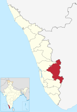
Idukki (ഇടുക്കി; IPA:[iɖukːi]ⓘ) is one of the 14 districts in the Indian state of Kerala in the southwest of the country.[5][6] It is the largest district in Kerala and lies amid the Cardamom Hills of Western Ghats in Kerala. Idukki district contains two municipal towns – Kattappana and Thodupuzha, and five taluks.
The district was constituted on 26 January 1972, by taking Peerumade, Udumbanchola, Devikulam taluks of the former High Range division from Kottayam district and the Thodupuzha taluk from Ernakulam district.[7] Its division was previously headquartered at Kottayam city but moved to Kuyilimala near Painavu and Cheruthoni in June 1976. Malayalam and English are the two official administrative languages in the district.[3] Tamil is the second most spoken language in Idukki district after Malayalam.[8]
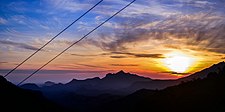
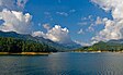
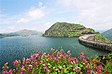
Around 66% of Kerala's power needs come from various Hydroelectric Power Projects in Idukki district.[1] Numerous cash crops and spices are cultivated throughout the district, making it The Spice Garden of Kerala.[1] A significant area in the district is protected as reserved forests and wildlife sanctuaries.[1] The Periyar River is a major river that originates and flows through Idukki. The Pamba River is another important river that originates from Idukki district.
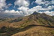
Though it is the largest district in the region in terms of area, it has the lowest population density among the districts of Kerala. There are only two municipalities in the district and the urban population is comparatively much lower than the rural population, due to its mountainous nature. The 2,695 metres (8,842 ft) high peak of Anamudi, which is also the highest point of elevation in India outside the Himalayas, lies in the northern portion of the district of Idukki.[9] The Idukki Dam is one of the highest arch dams in Asia.[10]
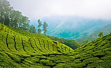
The major tourism destination of Idukki is Munnar.
^ abcd"The Spice Garden of Kerala". National Informatics Centre, Ministry of Electronics and Information Technology, Government of India. Retrieved 20 June 2022.
^Annual Vital Statistics Report – 2018(PDF). Thiruvananthapuram: Department of Economics and Statistics, Government of Kerala. 2020. p. 55. Archived from the original (PDF) on 2 November 2021. Retrieved 25 November 2020.
^ ab"The Kerala Official Language (Legislation) Act, 1969" (PDF).
^"Kerala | UNDP in India". UNDP.
^"Idukki | India". Encyclopedia Britannica. Retrieved 24 October 2021.
^Idukki District (Variant – V) at GEOnet Names Server, United States National Geospatial-Intelligence Agency
^"History of Idukki District". District Idukki, Government of India.
^"Table C-16 Population by Mother Tongue: Kerala". www.censusindia.gov.in. Registrar General and Census Commissioner of India.
^"Anamudi". Kerala Tourism. Retrieved 20 June 2022.
^"Idukki Arch Dam". Government of Kerala. Retrieved 20 June 2022.
Idukki (ഇടുക്കി; IPA: [iɖukːi] ) is one of the 14 districts in the Indian state of Kerala in the southwest of the country. It is the largest district...
between two granite hills locally known as Kuravan and Kurathi in Idukkidistrict in the state of Kerala, India. It is constructed and owned by the Kerala...
into 14 districts. Districts are the major administrative units of a state which are further sub-divided into revenue divisions and taluks. Idukki is the...
The District Panchayaths are the territory level of local government under Panchayathi Raj act in India. IdukkiDistrict Panchayath is in Kerala state...
IdukkiDistrict has four types of administrative hierarchies: Taluk and Village administration managed by the provincial government of Kerala Panchayath...
Idukki Wildlife Sanctuary is Wildlife Sanctuary located in Idukkidistrict of Kerala, India. Situated around the catchment area of Idukki Dam, the Idukki...
Idukki State assembly constituency is one of the 140 state legislative assembly constituencies in Kerala state in southern India. It is also one of the...
Idukki is a township in Idukkidistrict near to the district headquarter Painavu in the state of Kerala, southern India. The township consists of the towns...
Kolukkumalai is located in Theni district of Tamil Nadu. The approach road is through Suryanelli near Munnar in Idukkidistrict of Kerala. Visitor attractions...
year 1998, Kuttampuzha village was added to the district from Idukkidistrict following which the district got a political boundary with neighbouring state...
Peerumedu Taluk of Idukkidistrict (majority area including Vagamon town), and also Meenachil taluk and Kanjirappally taluk of Kottayam district in the state...
of Theni District of Tamil Nadu and IdukkiDistrict of Kerala, about 7 km from Pazhiyankudi in Theni district and 15 km from Thekkady in Idukki. Kannagi...
bridge is the longest cantilever glass bridge in IdukkiDistrict. It was built at the IdukkiDistrict Tourism Promotion Council (DTPC) adventure park with...
([kaʈ:ap:ɐna]) is a municipality in the Idukkidistrict of Kerala, India. It is located 26 km (16.2 mi) west of the district headquarters in Painavu and about...
Kerala (Idukkidistrict, Ernakulam district, Palakkad district, Thrissur district) and span the border of western Tamil Nadu (Coimbatore district and Tiruppur...
bounded by Tiruppur district in the east, Nilgiris district in the north, Erode district in the northeast, Palakkad district, Idukkidistrict and small parts...
Vattavada is a village in Idukkidistrict in the state of Kerala, bordering Tamil Nadu, India. The village is located along Palani Hills in Western Ghats...
Idukki, Ekalavya Model Residential School idukki, District Panchayath idukki, Kendriya Vidyalaya Idukki, Model Polytechnic College Painavu. Idukki Dam...
Kanthalloor is a village in Devikulam taluk , Idukkidistrict, Kerala. It is a village nestled in the Western Ghats of India. The salubrious climate and...
is a popular tourist destination located in Kanchiyar panchayat in Idukkidistrict, Kerala state, India. Anchuruli is famous for the 5.5 km (3.4 mi) long...
populous district in Kerala (out of 14), after Wayanad and Idukki. Pathanamthitta has been declared the first polio-free district in India. The district is...
Munnar (IPA: [muːn̪ːɐːr]) is a town and hill station located in the Idukkidistrict of the southwestern Indian state of Kerala. Munnar is situated at around...
northwest, Karur district in the north, Tiruchirappalli district in the northeast, Theni district in the Southwest and Idukkidistrict of Kerala to the...
 Global Information