• unorganized Territory (after Missouri became a state)
August 10, 1821
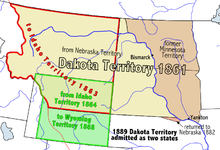
• Dakota Territotry
March 2, 1861
• North Dakota and South Dakota statehood
November 2, 1889
Preceded by
Succeeded by
Nebraska Territory
Unorganized territory
Idaho Territory
Wyoming Territory
North Dakota
South Dakota
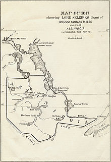
Assiniboia
The Pembina Region (/ˈpɛmbɪnə/PEM-bi-nə), also referred to as the Pembina District and Pembina Department,[1] is the historic name of an unorganized territory of land that was ceded to the United States in 1818. The area included the portions of what became the States of Minnesota, North Dakota, and South Dakota lying within the Hudson Bay drainage basin. The area included settlements in the Pembina River area. The region was formerly part of British Rupert's Land, granted by British royal charter to the Hudson's Bay Company. After the Selkirk Concession and establishment of the agricultural Red River Colony in 1812, the area was governed as the District of Assiniboia. The Treaty of 1818 de jure transferred the region south of the 49th parallel to the United States from the British. Settlements south of the boundary continued to be de facto administered as part of Assiniboia until at least 1823.
The area was referred to as the Pembina District after the U.S. Army Major Stephen Harriman Long made surveys during the 1823 expedition to the Red River of the North and placed an International boundary marker north of Pembina clearly defining the border between the United States and British North America. Prior to 1823, the Pembina settlement was believed by both countries to be within the boundary of British North America.
Several attempts at formal recognition and naming failed to pass Congress. In 1849 Father Georges-Antoine Belcourt described the area, referred to as Pembina district or department, as a country about 400 miles from north to south and more than five hundred miles from east to west.[2] The region was considered unorganized territory from 1818 until June 28, 1834, when Congress assigned it to the Michigan Territory. Subsequently, the region was successively a part of Iowa Territory, Wisconsin Territory, and finally Minnesota Territory. When Minnesota became a state on May 11, 1858, and its western boundary was set at the Red River, the western part of the Pembina region again became unorganized territory. Organization of Dakota Territory on March 2, 1861 marked the final establishment of organized territorial government.
The portion of the historic Pembina region not incorporated into the State of Minnesota was apportioned to the States of North and South Dakota on their admission to the Union of November 2, 1889.
^"Pembina State Museum - The Pembina Region". State Historical Society of North Dakota. Retrieved 3 October 2015.
^"The History and Culture of the Turtle Mountain Band of Chippewa". North Dakota Studies. Archived from the original on 18 November 2015. Retrieved 3 October 2015.
The PembinaRegion (/ˈpɛmbɪnə/ PEM-bi-nə), also referred to as the Pembina District and Pembina Department, is the historic name of an unorganized territory...
The Pembina Valley /ˈpɛmbɪnə/ (French: Vallée-de-la-Pembina) is an informal geographic region of the Canadian province of Manitoba. It is named for its...
Edmonton Pembina Institute, an environmental research group Pembina oil field, an oil- and gas-producing region in central Alberta Pembina Pipeline,...
In the region of Drayton-Pembina, the gradient is only 1.5 inches per mile. The water tends to pool in this area during flood season. The region can become...
traced back to 1954 when the Pembina pipeline system was built to serve the Pembina oil field in the Drayton Valley region. For the next 37 years, the...
field is centered on Drayton Valley and is named for the Pembina River, which crosses the region from southwest to northeast. It taps reservoirs in the...
(annexed by the U.S., 1810) Mobile District (annexed by the U.S., 1812) PembinaRegion, formerly part of Rupert's Land and the Red River Colony; (often referred...
Lake region may have occurred between 1650 and 1750. By that time, Anishinaabe people were already living in the Grand Portage, Rainy Lake, and Pembina region...
century, the tribe was numbered at several thousand in the Red River-Pembinaregion. At that time there was no formal enrollment procedure, no reservation...
The Pembina Escarpment is a scarp that runs from South Dakota to Manitoba, and forms the western wall of the Red River Valley. The height of the escarpment...
The Pembina Curling Club located in Winnipeg, Manitoba, is a six-sheet curling club located in the south part of the city. The club was established in...
the Pembina Valley Region to the south, the Central Plains Region composes the broader cultural region of Central Manitoba. Geographically, the region is...
territory. O'Neill, J. J. Donnelly and ten others were taken prisoner near Pembina, Dakota Territory, by U.S. soldiers led Captain Loyd Wheaton. The farcical...
berries for many years. The Canadian French name for the berries is pembina. The name pembina was then applied to three rivers, one in Manitoba and North Dakota...
Stuartburn Area Taché Area South Central Economic Region — comprising all of the Pembina Valley region (census divisions 3 and 4), and can further be broken...
although the majority are based in either the Winnipeg Metropolitan Region or the Eastman Region. A number of small municipalities also have high francophone...
basins. The northern and western sectors of the county are drained by the Pembina River which flows north to meet the Athabasca River, which drains into...
encompasses the Winnipeg Metropolitan Region, Westman Region, Central Plains Region, Eastman Region, and Pembina Valley Region, as well as the Manitoba portion...
 Global Information