Global Information Lookup Global Information

Panay information


Panay
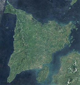
Panay island satellite image captured by Sentinel-2 in 2016
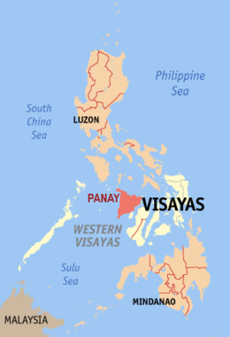
Location within the Philippines
Geography
LocationSouth East Asia
Coordinates11°09′N 122°29′E / 11.150°N 122.483°E / 11.150; 122.483
ArchipelagoVisayas
Adjacent to
  • Cuyo East Pass
  • Guimaras Strait
  • Iloilo Strait
  • Jintotolo Channel
  • Panay Gulf
  • Sibuyan Sea
  • Sulu Sea
  • Visayan Sea
Area12,011 km2 (4,637 sq mi)[1]
Area rank65th
Highest elevation2,117 m (6946 ft)[2]
Highest pointMount Madja-as
Administration
Philippines
RegionWestern Visayas
Provinces
  • Aklan
  • Antique
  • Capiz
  • Iloilo
Largest settlementIloilo City (pop. 457,626)
Demographics
DemonymPanayan/Panayanon
Population4,542,926 (2020)[3]
Pop. density358/km2 (927/sq mi)
Ethnic groups
  • Visayans (Hiligaynon, Karay-a, Capiznon, Aklanon, Caluyanon)
  • Ati
  • Suludnon

Panay is the sixth-largest and fourth-most populous island in the Philippines, with a total land area of 12,011 km2 (4,637 sq mi) and has a total population of 4,542,926 as of 2020 census.[4] Panay comprises 4.4 percent of the entire population of the country.[5] The City of Iloilo is its largest settlement with a total population of 457,626 inhabitants as of 2020 census.

Panay is a triangular island, located in the western part of the Visayas. It is about 160 km (99 mi) across. It is divided into four provinces: Aklan, Antique, Capiz, and Iloilo, all in the Western Visayas Region. Just closely off the mid-southeastern coast lies the island-province of Guimaras. It is located southeast of the island of Mindoro and northwest of Negros across the Guimaras Strait. To the north and northeast is the Sibuyan Sea, Jintotolo Channel and the island-provinces of Romblon and Masbate; to the west and southwest is the Sulu Sea and the Palawan archipelago[6] and to the south is Panay Gulf. Panay is the only main island in the Visayas whose provinces don't bear the name of their island.

Panay is bisected by the Central Panay Mountain Range, its longest mountain chain. The island has many rivers, the longest being the Panay River at a length of 168 kilometres (104 mi), followed by the Jalaur, Aklan, Sibalom, Iloilo and Bugang rivers. Standing at about 2,117 m (6,946 ft), the dormant Mount Madja-as (situated in Culasi, Antique) is the highest point of the island,[2] with Mount Nangtud (located between Barbaza, Antique and Jamindan, Capiz) following next at 2,073 m (6,801 ft).

Historically, the terms Bisaya or Visayan were first used to refer only to the people of this island, the Panayan or Hiligaynon people, and to their other settlements on the nearby islands, in the western portion of Negros Island and the smaller islands of Romblon and Guimaras.[7] Panay also originally represented the entire Visayas region on the Philippine flag as one of the three stars, as it served as the center or mainland of the Visayas during the Philippine Revolution.[8]

The island lent its name to several United States Navy vessels including USS Panay (PR-5), sunk in 1937 by the Japanese in the USS Panay incident.

  1. ^ "Islands by Land Area". Island Directory Tables. United Nations Environment Programme. Retrieved June 7, 2021.
  2. ^ a b Cite error: The named reference pn was invoked but never defined (see the help page).
  3. ^ Census of Population (2020). Table B - Population and Annual Growth Rates by Province, City, and Municipality - By Region. Philippine Statistics Authority. Retrieved 8 July 2021.
  4. ^ Census of Population (2015). Highlights of the Philippine Population 2015 Census of Population. Philippine Statistics Authority. Retrieved 20 June 2016.
  5. ^ Boquet, Yves (2017). The Philippine Archipelago. Springer Geography. Cham, Switzerland: Springer. p. 16. ISBN 978-3-319-51926-5.
  6. ^ Hogan, C. Michael (2011) [2009]. "Sulu Sea". Encyclopedia of Earth. Archived from the original on 2012-05-04.
  7. ^ Steiger, G. Nye; Beyer, H. Otley; Benitez, Conrado (1929). A History of the Orient. Oxford: Ginn and Company. pp. 122–123.
  8. ^ "NCCA-Symbolisms/Meanings in the Philippine Flag". National Commission for Culture and the Arts. Retrieved 2022-04-24.

and 22 Related for: Panay information

Request time (Page generated in 0.7478 seconds.)

Panay

Last Update:

Panay is the sixth-largest and fourth-most populous island in the Philippines, with a total land area of 12,011 km2 (4,637 sq mi) and has a total population...

Word Count : 4614

USS Panay incident

Last Update:

The USS Panay incident on December 12, 1937, was a Japanese bombing attack on the U.S. Navy river gunboat Panay and three Standard Oil Company tankers...

Word Count : 2390

USS Panay

Last Update:

of the United States Navy have been named USS Panay, after the Visayan island Panay. The first USS Panay (1899) was originally a Spanish gunboat, in the...

Word Count : 174

Panay Church

Last Update:

Mónica), also called Panay Church, is a historic Roman Catholic church in Panay, near Roxas City in the province of Capiz, on Panay island in the Western...

Word Count : 303

Iloilo

Last Update:

Visayas. Iloilo occupies the southeast portion of the Visayan island of Panay and is bordered by the province of Antique to the west, Capiz to the north...

Word Count : 5657

Panay Gulf

Last Update:

Panay Gulf is an extension of the Sulu Sea, reaching between the islands of Panay and Negros in the Philippines. The gulf contains the island-province...

Word Count : 143

Panay Liberation Day

Last Update:

Panay Liberation Day, alternatively Panay Landing Day and Victory (Liberation) Day on Panay is an annual event that commemorates the landing on Panay...

Word Count : 1045

Western Visayas

Last Update:

Budget and Management. Western Visayas consists of the major island of Panay and the smaller Guimaras, as well as several outlying islands. It also includes...

Word Count : 1257

Japanese invasion of Panay

Last Update:

Japanese invasion of Panay (Filipino: Paglusob ng mga Hapones sa isla ngPanay, Cebuano: Pagsulong sa Hapon sa Panay) on April 16–18, 1942 was the second...

Word Count : 510

Panos Panay

Last Update:

Panos Panay may refer to: Panos Panay (music executive) (born 1972), Cypriot/American music executive Panos Panay (technology executive), American technology...

Word Count : 58

Panay River

Last Update:

The Panay River (known as Pan-ay River) is the longest river on Panay Island in the Philippines, with a total length of approximately 152 kilometres (94 mi)...

Word Count : 240

Hiligaynon people

Last Update:

the Visayan branch native to Panay, Guimaras, and Negros. They originated in the province of Iloilo, on the island of Panay, in the region of Western Visayas...

Word Count : 3367

Mount Panay

Last Update:

Mount Panay is a potentially active stratovolcano located in the province of Batangas, Philippines. Panay is located south of Taal Lake, in the province...

Word Count : 233

Panay monitor

Last Update:

The Panay monitor (Varanus mabitang) is an endangered monitor lizard native to Panay Island in the Philippines. Unlike most monitors, it is a specialized...

Word Count : 497

Capiz

Last Update:

capital is the city of Roxas. It is located at the northeastern portion of Panay Island, bordering Aklan to the north, Antique to the west, and Iloilo to...

Word Count : 3502

Panay Railways

Last Update:

Panay Railways Inc. is a government-owned and controlled corporation of the Philippines headquartered in La Paz, Iloilo City on the island of Panay. It...

Word Count : 2549

Just Cause 2

Last Update:

nation in Maritime Southeast Asia) to overthrow dictator Pandak "Baby" Panay and confront former mentor Tom Sheldon. The gameplay involves Rico fighting...

Word Count : 4763

Visayas

Last Update:

predominantly the Visayan peoples. The major islands of the Visayas are Panay, Negros, Cebu, Bohol, Leyte and Samar. The region may also include the provinces...

Word Count : 3786

Panay cloudrunner

Last Update:

The Panay cloudrunner (Crateromys heaneyi) is the second-largest cloud rat, a squirrel-like rodent that is found on the island of Panay in the Philippines...

Word Count : 279

Pueblo de Panay

Last Update:

Pueblo de Panay Township is a 670-hectare (1,700-acre) mixed-use community development in Roxas City, Capiz, Philippines by Pueblo de Panay, Inc. (PDPI)...

Word Count : 511

Suludnon

Last Update:

The Suludnon, also known as the Panay-Bukidnon, Pan-ayanon, or Tumandok, are a culturally indigenous Visayan group of people who reside in the Capiz-Antique-Iloilo...

Word Count : 488

Bisayan languages

Last Update:

West Aklan (spoken in northwestern Panay) Aklanon/Inakeanon Malaynon Karayan Karay-a (spoken in western and inland Panay) North-Central (spoken on Tablas...

Word Count : 954

PDF Search Engine © AllGlobal.net