"Canal Zone" redirects here. For the film, see Canal Zone (film). For the unofficial region in Egypt, see Suez Canal.
Panama Canal Zone
Zona del Canal de Panamá
1903–1979
Flag
Seal
Motto: The Land Divided, The World United
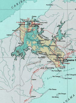
Map of Panama Canal Zone. The Caribbean Sea is at the top left, the Gulf of Panama is at bottom right
Status
Concession of the United States in Panama
Capital
Balboa
Common languages
Spanish, English
Demonym(s)
Zonian
Governor
• 1904–1905
George Whitefield Davis (First Military)
• 1913–1914
Richard Lee Metcalfe (Last Military)
• 1914–1917
George Washington Goethals (First Civil)
• 1975–1979
Harold Parfitt (Last Civil)
History
• Hay–Bunau-Varilla Treaty
November 18, 1903
• Torrijos–Carter Treaties
October 1, 1979
Area
• Total
1,432 km2 (553 sq mi)
Currency
United States dollar Panamanian balboa (tolerated)
Preceded by
Succeeded by
Panama
Panama
Today part of
Panama
The Panama Canal Zone (Spanish: Zona del Canal de Panamá), also simply known as the Canal Zone, was a concession of the United States located in the Isthmus of Panama that existed from 1903 to 1979. It consisted of the Panama Canal and an area generally extending five miles (8 km) on each side of the centerline, but excluding Panama City and Colón.[1] Its capital was Balboa.
The Panama Canal Zone was created on November 18, 1903 from the territory of Panama; established with the signing of the Hay–Bunau-Varilla Treaty, which allowed for the construction of the Panama Canal within the territory by the United States. The zone existed until October 1, 1979, when it was incorporated back into Panama.
In 1904, the Isthmian Canal Convention was proclaimed. In it, the Republic of Panama granted to the United States in perpetuity the use, occupation, and control of a zone of land and land underwater for the construction, maintenance, operation, sanitation, and protection of the canal. From 1903 to 1979, the territory was controlled by the United States, which had purchased the land from its private and public owners, built the canal and financed its construction. The Canal Zone was abolished in 1979, as a term of the Torrijos–Carter Treaties two years earlier; the canal itself was later under joint U.S.–Panamanian control until it was fully turned over to Panama in 1999.[2]
^Cite error: The named reference Liptak1 was invoked but never defined (see the help page).
^"Panamanian Control", Panama Canal, infoplease.com, archived from the original on May 24, 2008, retrieved June 2, 2008
The PanamaCanalZone (Spanish: Zona del Canal de Panamá), also simply known as the CanalZone, was a concession of the United States located in the Isthmus...
The PanamaCanal (Spanish: Canal de Panamá) is an artificial 82-kilometre (51-mile) waterway in Panama that connects the Atlantic Ocean with the Pacific...
The idea of the PanamaCanal dates back to 1513, when Vasco Núñez de Balboa first crossed the Isthmus of Panama. This narrow land bridge between North...
governors of the PanamaCanalZone while it was under U.S. control. PanamaCanalZone "Biographies of CanalZone Governors". PanCanal. Retrieved 2014-11-22...
Naval Base PanamaCanalZone refers to a number of United States Navy bases used during World War II to both protect the PanamaCanal and the key shipping...
military installations in Panama, all of which fall within the former Canalzone. The U.S. military installations in Panama were turned over to local...
The seal and flag were the symbols of the PanamaCanalZone, an unincorporated territory of the United States, that existed from 1903 to 1979. The seal...
with the PanamaCanalZone, a political entity which existed between 1903 and the absorption of the CanalZone into the Republic of Panama between 1979...
with modern-day Cativá in Panama. It was on the Atlantic Ocean (northwest) side of the PanamaCanalZone, near Colón, Panama. Five C-class submarines were...
The PanamaCanal Railway (PCR, Spanish: Ferrocarril de Panamá) is a railway line linking the Atlantic Ocean to the Pacific Ocean in Central America. The...
PanamaCanal Division was a unit of the United States Army, established in order to ensure the United States could adequately defend the CanalZone in...
the former PanamaCanalZone, later part of the Republic of Panama. Fort Clayton was located northwest of Balboa, Panama, with the PanamaCanal located nearby...
personnel. Some tensions arose between the people of Panama and the U.S. citizens living in the PanamaCanalZone. This erupted in the 9 January 1964 events, known...
constructing the canal, the U.S. was granted a perpetual lease on the land around the canal, known as the PanamaCanalZone, which was returned to Panama in 1999...
States Army base in Panama, located on Toro Point at the Caribbean (northern) end of the PanamaCanal, on the western bank of the Canal directly opposite...
history of the CanalZone is a subject that covers the postal system, postage stamps used and mail sent to and from the PanamaCanalZone from 1904 up until...
One of the greatest challenges facing the builders of the PanamaCanal was dealing with the tropical diseases rife in the area. The health measures taken...
of more than 400 officers and was responsible for the security of PanamaCanalZone property, as well as general policing duties, using a wide range of...
the one in Santa Ana, Panama City. During the construction of the PanamaCanal (1904-1914), many prostitutes came to the canalzone to service the workers...
Court for the CanalZone (in case citations, D.C.Z.) was a United States District Court which existed in the PanamaCanalZone of Panama from 1914 to 1982...
The PanamaCanal fence is a term used for a variety of barriers built by the United States in the PanamaCanalZone to control movement in the zone for...
 Global Information