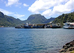
Pago Pago Harbor is capable of accommodating the largest cruise ships.[1]A portion of the docks at Fagatogo in Pago Pago Harbor. In the background is Rainmaker Mountain.
Pago Pago Harbor on Tutuila Island in American Samoa is one of the world's largest natural harbors.[2] The capital, Pago Pago is located on the inner reaches of the harbor, close to its northwesternmost point. It has the highest annual rainfall of any harbor in the world.[3] It is also considered one of the best and deepest deepwater harbors in the South Pacific Ocean or in Oceania as a whole.[4][5] Pago Pago Bay is over 400 feet (120 m) deep and two miles (3.2 km) long. As part of the Pago Volcano caldera, the harbor is 50% landlocked.[6]
Villages along the harbor include several communities in the Greater Pago Pago Area, including Utulei, Fagatogo, Malaloa, Pago Pago proper, Satala, Anua and Atu'u. The legislature and High Court are located in Fagatogo, while the executive offices are located in Utulei.[7]
Pago Pago Harbor is surrounded and sheltered by mountains such as Mount ʻAlava, Mount Matafao and Rainmaker Mountain (Mount Pioa).[8] The entrance to Pago Pago Bay is marked by two mountains: Peiva in the east and Matafao Peak in the west.[9] The harbor is all that remains from the volcanic crater that built Tutuila Island. At some point, one wall of the crater collapsed and the sea came rushing in creating a near complete shelter from the power of the sea at large.[10]
The village communities which lie within the Pago Pago Bay Area are jointly known as Ma'upūtasi (“the only house of chiefs”). They are Pago Pago, Aūa, Fagatogo, Leloaloa and Faga'alu.[9]
^Joanne Thomas. "American Samoa Cruises". USA Today.
^"Archived copy" (PDF). Archived from the original (PDF) on 2017-01-30. Retrieved 2017-10-24.{{cite web}}: CS1 maint: archived copy as title (link)
^"Archived copy". Archived from the original on 2017-10-19. Retrieved 2017-10-19.{{cite web}}: CS1 maint: archived copy as title (link)
^United States Central Intelligence Agency (2016). The World Factbook 2016-17. Government Printing Office. Page 19. ISBN 9780160933271. - Grabowski, John F. (1992). U.S. Territories and Possessions (State Report Series). Chelsea House Pub. Page 52. ISBN 9780791010532.
^Kristen, Katherine (1999). Pacific Islands (Portrait of America). San Val. Page 12. ISBN 9780613032421.
^Shaffer, Robert J. (2000). American Samoa: 100 Years Under the United States Flag. Island Heritage. Page 30. ISBN 9780896103399.
^Tutuila Island Map, National Park Service.
^"Port of Pago Pago, American Samoa". Department of Port Administration. Retrieved 17 August 2022.
^ abKrämer, Augustin (2000). The Samoa Islands. University of Hawaii Press. Page 436. ISBN 9780824822194.
^Swaney, Deanna (1994). Samoa: Western & American Samoa: a Lonely Planet Travel Survival Kit. Lonely Planet Publications. Page 164. ISBN 9780864422255.
Greater PagoPago Metropolitan Area encompasses several villages strung together along PagoPagoHarbor. One of the villages is itself named PagoPago, and...
ship from San Diego, California. VMF-111 aircraft were off loaded in PagoPagoharbor and trucked to Tafuna airfield. The first planes from MAG-13 also arrived...
PagoPagoHarbor on Tutuila Island in American Samoa is one of the world's largest natural harbors. The capital, PagoPago is located on the inner reaches...
contains a large, natural harbor, PagoPagoHarbor, where PagoPago, the capital of American Samoa, is situated. PagoPago International Airport is also...
Tutuila Pago PagoHarbor in American Samoa Pago del Vallo di Lauro, a town and comune in the province of Avellino, Campania, Italy. Pago Veiano, a comune...
These two villages are located along PagoPagoHarbor, whose largest village is PagoPago. Many sources list PagoPago as the capital, referring to the whole...
near PagoPago, American Samoa on Tutuila Island. Rainmaker Mountain traps rain clouds and gives PagoPago the highest annual rainfall of any harbor. The...
Haven in Wales, United Kingdom New York Harbor in the United States PagoPagoHarbor in American Samoa Pearl Harbor in Hawaii, United States Poole Harbour...
The aircraft developed an oil leak shortly after taking off from PagoPagoharbor, and the crew decided to return to port. However, the S-42, fully loaded...
South of PagoPago is a 1940 American South Seas adventure film directed by Alfred E. Green and starring Victor McLaglen, Jon Hall and Frances Farmer...
United States Naval Station Tutuila was a naval station in PagoPagoHarbor on the island of Tutuila, part of American Samoa, built in 1899 and in operation...
Representatives and a Senate. The legislature is located in Fagatogo along PagoPagoharbor. It is the only legislature on the state or territorial level in the...
026 cm) measured annually in the Big Bog, in Maui. PagoPagoHarbor in American Samoa is the rainiest harbor in the world (because of the 523 meter Rainmaker...
It is located at the easternmost point of the entrance to PagoPagoHarbor, south of PagoPago. Flowerpot Rock, also known as Fatu Rock, is found along...
County Ta'u County Villages of American Samoa Capital of American Samoa: PagoPago Villages of American Samoa Aasu Afao Afono Agugulu Alao Alega Alofau Amaluia...
the island's least populous villages, it is located to the east of PagoPagoHarbor and to the west of Faga'itua Bay. Alega, with a population of 29 according...
close to the capital PagoPago, on the coast of PagoPagoHarbor. The term PagoPago is often used for several settlements on PagoPago Bay, including Anua...
PagoPagoHarbor in American Samoa. It is located in-between Fagatogo proper and the village of PagoPago. Cruising boats entering and leaving Pago Pago...
lies along the coast to the northwest, and to Aua, on the edge of PagoPagoHarbor to the south via a winding stretch of highway which crosses the spine...
peak on Tutuila Island. The mountain, like Rainmaker Mountain across PagoPagoHarbor, is a remnant of a volcanic plug and is part of the volcanic origins...
 Global Information