Canada: 8,864 km (5,508 mi) Mexico: 3,327 km (2,067 mi)
Highest point
Denali 6,190.5 m (20,310 ft)
Lowest point
Badwater Basin, −85 m (−279 ft)
Longest river
Missouri River, 3,767 km (2,341 mi)
Largest lake
Lake Superior 58,000 km2 (22,394 sq mi)
Climate
Diverse: Ranges from warm-summer continental in the far north to tropical in the far south. West: mostly semi-arid to desert, Mountains: alpine, Northeast: humid continental, Southeast: humid subtropical, Coast of California: Mediterranean, Pacific Northwest: cool temperate oceanic, Alaska: mostly subarctic, Hawaii, South Florida, and the territories: tropical
Terrain
Vast central plain, Interior Highlands and low mountains in Midwest, mountains and valleys in the mid-south, coastal flatland near the Gulf and Atlantic coasts, complete with mangrove forests and temperate, subtropical, and tropical laurel forest and jungle, canyons, basins, plateaus, and mountains in west, hills and low mountains in east; intermittent hilly and mountainous regions in Great Plains, with occasional badland topography; rugged mountains and broad river valleys in Alaska; rugged, volcanic topography in Hawaii and the territories
Tsunamis; volcanoes; earthquake activity around Pacific Basin; hurricanes along the Atlantic and Gulf of Mexico coasts; tornadoes in the Midwest and Southeast; mud slides in California; forest fires in the west; flooding; permafrost in northern Alaska
Environmental issues
Environmental issues
Deforestation, energy irresponsibility, pollution, nuclear waste, Severe water shortages, air pollution resulting in acid rain in both the US and Canada
Exclusive economic zone
11,351,000 km2 (4,383,000 sq mi)
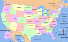
The term "United States," when used in the geographical sense, refers to the contiguous United States (sometimes referred to as the Lower 48, including the District of Columbia), Alaska, Hawaii, the five insular territories of Puerto Rico, Northern Mariana Islands, U.S. Virgin Islands, Guam, American Samoa, and minor outlying possessions.[1] The United States shares land borders with Canada and Mexico and maritime borders with Russia, Cuba, The Bahamas, and many other countries, mainly in the Caribbean[note 2]in addition to Canada and Mexico. The northern border of the United States with Canada is the world's longest bi-national land border.
Cite error: There are <ref group=note> tags on this page, but the references will not show without a {{reflist|group=note}} template (see the help page).
^U.S. State Department, Common Core Document to U.N. Committee on Human Rights, December 30, 2011, Item 22, 27, 80; Homeland Security Public Law 107-296 Sec.2.(16)(A); Presidential Proclamation of national jurisdiction [1]
^https://www.britannica.com/place/United-States-Virgin-Islands. Britannica.com. United States Virgin Islands. Retrieved July 3, 2020. Archived April 29, 2020, at the Wayback Machine
^https://www.britannica.com/place/Puerto-RicoBritannica.com. Puerto Rico. Retrieved July 3, 2020. Archived July 2, 2020, at the Wayback Machine
^Anderson, Ewan W. (2003). International Boundaries: A Geopolitical Atlas. Routledge: New York. ISBN 9781579583750; OCLC 54061586
^Charney, Jonathan I., David A. Colson, Robert W. Smith. (2005). International Maritime Boundaries, 5 vols. Hotei Publishing: Leiden.
^http://www.pacgeo.org/static/maritimeboundaries/Pacgeo.org. Maritime Boundaries. Retrieved July 3, 2020. Archived July 31, 2020, at the Wayback Machine
and 27 Related for: Geography of the United States information
The term "UnitedStates," when used in thegeographical sense, refers to the contiguous UnitedStates (sometimes referred to as the Lower 48, including...
Thegeographic center oftheUnitedStates is a point approximately 20 mi (32 km) north of Belle Fourche, South Dakota at 44°58′2.07622″N 103°46′17.60283″W...
The Northeastern UnitedStates, also referred to as the Northeast, the East Coast, or the American Northeast, is a geographic region oftheUnited States...
013 km2). Geography portal North America portal UnitedStates portal Aboriginal title in theUnitedStates Historic regions oftheUnitedStates List of Indian...
The physiographic regions ofthe contiguous UnitedStates comprise 8 divisions, 25 provinces, and 85 sections. The system dates to Nevin Fenneman's report...
This is a list ofgeographic centers of each U.S. state and inhabited territory. Thegeographic center oftheUnitedStates is northeast of Belle Fourche...
disciplines of biology, geography, geology, and hydrology. The agency was founded on March 3, 1879, to study the landscape oftheUnitedStates, its natural...
The following outline is provided as an overview of and topical guide to theUnitedStates: UnitedStatesof America – federal republic located primarily...
TheUnitedStatesof America (USA or U.S.A.), commonly known as theUnitedStates (US or U.S.) or America, is a country primarily located in North America...
is a list of ports oftheUnitedStates, ranked by tonnage. Ports in theUnitedStates handle a wide variety of goods that are critical to the global economy...
geographic territory. TheUnitedStates comprises 50 states: 9 ofthe Thirteen Colonies that were already part oftheUnitedStates at the time the Constitution...
TheUnitedStates has land borders with only Canada and Mexico, both of them long. Its has maritime boundaries with many countries due to its extensive...
by theUnitedStates Census Bureau as a U.S. geographic division. There are conflicting definitions of which states comprise the West Coast ofthe United...
is in the public domain. Hooglund, Eric; Toth, Anthony (1994). "United Arab Emirates: Geography". In Metz, Helen Chapin (ed.). Persian Gulf states: country...
The president oftheUnitedStates (POTUS) is the head of state and head of government oftheUnitedStatesof America. The president directs the executive...
and The Bahamas. Thirteen states lie on the U.S.–Canada border. The U.S. statesof Indiana, Illinois, and Wisconsin do not share a direct geographic border...
 Global Information