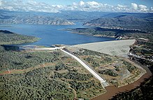
Oroville Dam is an earthfill embankment dam on the Feather River east of the city of Oroville, California, in the Sierra Nevada foothills east of the Sacramento Valley. At 770 feet (235 m) high, it is the tallest dam in the U.S.[8] and serves mainly for water supply, hydroelectricity generation, and flood control. The dam impounds Lake Oroville, the second-largest reservoir in California, capable of storing more than 3.5 million acre-feet (1.1×10^12 US gal; 4.3×10⁹ m3).[9]
Built by the California Department of Water Resources, Oroville Dam is one of the key features of the California State Water Project (SWP), one of two major projects passed that set up California's statewide water system. Construction was initiated in 1961, and despite numerous difficulties encountered during its construction, including multiple floods and a major train wreck on the rail line used to transport materials to the dam site, the embankment was topped out in 1967 and the entire project was ready for use in 1968. The dam began to generate electricity shortly afterwards with completion of the Edward Hyatt Power Plant, then the country's largest underground power station.
Since its completion in 1968, the Oroville Dam has allocated the flow of the Feather River from the Sacramento-San Joaquin Delta into the SWP's California Aqueduct, which provides a major supply of water for irrigation in the San Joaquin Valley, as well as municipal and industrial water supplies to coastal Southern California, and has prevented large amounts of flood damage to the area—more than $1.3 billion between 1987 and 1999.[10] The dam stops fish migration up the Feather River and the controlled flow of the river; as a result, the Oroville Dam has affected riparian habitat. Multiple attempts at trying to counter the dam's impacts on fish migration have included the construction of a salmon/steelhead fish hatchery on the river, which began shortly after the dam was completed.
In February 2017, the main and emergency spillways threatened to fail, leading to the evacuation of 188,000 people living near the dam.[11] After deterioration of the main spillway largely stabilized[12] and the water level of the dam's reservoir dropped below the top of the emergency spillway, the evacuation order was lifted.[13]
The main spillway was reconstructed by November 1, 2018, and water releases were successfully tested, up to 25,000 cu ft/s (710 m3/s), during April 2019.
^"Lake Oroville". Geographic Names Information System. United States Geological Survey, United States Department of the Interior. January 19, 1981. Retrieved March 31, 2012.
^ ab"Oroville Dam". National Performance of Dams Program. Stanford University. Retrieved March 31, 2012.[permanent dead link]
^ ab"Oroville Facilities (FERC Project No. 2100)" (PDF). California Department of Water Resources. January 2005. Archived from the original (PDF) on May 25, 2017. Retrieved February 13, 2017.
^ abc"Oroville Dam (ORO)". California Data Exchange Center. California Department of Water Resources. Retrieved March 31, 2012.
^Ritzema, Randall S.; Newlin, Brad D.; Van Lienden, Brian J. (October 2001). "Appendix H: Infrastructure" (PDF). CALVIN Project. University of California Davis. Archived from the original (PDF) on November 6, 2017. Retrieved January 25, 2014.
^ abCite error: The named reference power was invoked but never defined (see the help page).
^"California Hydroelectric Statistics & Data". California Energy Commission. Archived from the original on February 26, 2018. Retrieved April 26, 2018.
^"Dam, Hydropower and Reservoir Statistics". United States Society on Dams. Archived from the original on March 25, 2012. Retrieved March 31, 2012.
^"Alphabetical List of California Dams (Over 40,000 acre feet)". Civil and Environmental Engineering. University of California Davis. Archived from the original on February 5, 2012. Retrieved March 31, 2012.
^"The Benefits of Dams to Society". USCOLD Newsletter. United States Society on Dams. March 1999. Archived from the original on October 1, 2012. Retrieved September 4, 2012.
^188,000 under evacuation orders near Northern California dam Archived February 23, 2017, at the Wayback Machine
^"Updates: New storms approach, but officials confident Oroville Dam and spillways will hold up". Orlande Sentinel. Retrieved February 23, 2017.
^Cite error: The named reference LiftOrdersCNBC was invoked but never defined (see the help page).
OrovilleDam is an earthfill embankment dam on the Feather River east of the city of Oroville, California, in the Sierra Nevada foothills east of the...
In February 2017, heavy rainfall damaged OrovilleDam's main and emergency spillways, prompting the evacuation of more than 180,000 people living downstream...
Lake Oroville is a reservoir formed by the OrovilleDam impounding the Feather River, located in Butte County, northern California. The lake is situated...
of the U.S.'s taller dams are located in the west because of the steeper and more rugged topography. The tallest is OrovilleDam in northern California...
Lake Oroville, in Butte County, California, USA OrovilleDam, in Butte County, California, USA Oroville Municipal Airport, in Butte County, California...
multipurpose projects. The dam, at 741 ft (226 m), is one of the highest gravity dams in the world (compared to USA's largest OrovilleDam at 770 ft). The 166 km2...
the upper basin. The main stem Feather River begins at OrovilleDam, the outlet of Lake Oroville. From there the river flows generally south across the...
man-made dams by volume of fill/structure. By general definition, a dam is a barrier that impounds water or underground streams, hence tailings dams are relegated...
construction of a key facility in the operation of the State Water Project: OrovilleDam. The DWR and the United States Bureau of Reclamation also signed an agreement...
dipole was apparently reversed. In February 2017, heavy rainfall damaged OrovilleDam's main and emergency spillways, prompting the evacuation of more than...
into Lake Oroville, which is formed by the OrovilleDam several miles above the city of Oroville. At 770 feet (230 m), Oroville is the tallest dam in the...
and around the Diversion Pool and Thermalito Forebay, downstream of OrovilleDam." The park and lake support outdoor recreation such as camping, picnicking...
flows damaged the spillway of OrovilleDam in Butte County. However, due to heavy storm runoff into Lake Oroville, dam operators were forced to continue...
Elsman". Find Lakes. Retrieved February 23, 2012. "OrovilleDam is the tallest earthen embankment dam in the United States". California Department of Water...
highest earthfill dam in the world until eclipsed by the OrovilleDam, also in California, in 1968. The latter remains the tallest dam in the United States...
failures Operation Chastise Malpasset Dam St. Francis Dam Taum Sauk Hydroelectric Power Station "1935 Sella Zerbino Dam-Break Case Revisited: A New Hydrologic...
Russia The OrovilleDam in the United States The El Cajón Dam in Honduras The Bhakra Dam in India The Luzzone Dam in Switzerland The Hoover Dam in the United...
southwards from its headwaters near Lassen Peak to Lake Oroville, a reservoir formed by OrovilleDam in the foothills of the Sierra, where it runs into the...
1981-01-19. Retrieved 2011-06-20. "USGS Gage #11406800 on Lake Oroville near Oroville, CA (Water-Data Report 2008)" (PDF). National Water Information...
Marysville Dam. Marysville Dam was supposed to be built as part of a system of dams in the Sacramento Basin along with New Bullards Bar and OrovilleDam, but...
exposed at low water Dam safety system Reservoir Stepped spillway Fish ladder Tailrace fishing Toddbrook Reservoir OrovilleDam crisis Henry H., Thomas...
Hydrology". Boulder Canyon Project–Hoover Dam. U.S. Bureau of Reclamation. 2012-01-04. Retrieved 2012-05-12. "OrovilleDam (ORO)". California Data Exchange Center...
town of Oroville, California and at a depth of about 5 kilometres (3.1 mi) below the OrovilleDam and the lake created as a result of the dam's construction...
deliver water to Los Angeles and the San Francisco Bay Area. OrovilleDam – the tallest dam in the U.S. – was built on the Sacramento's largest tributary...
railway ceased operation after portions of the grade were flooded by OrovilleDam during the Christmas flood of 1964. Trains portal Barnhill Web Design...
(Dark Canyon Road) that was used before the Feather River was dammed to create Lake Oroville in the 1960s. After crossing through Jarbo Gap, SR 70 drops...
tributaries of the Feather River. OrovilleDam creates the largest SWP reservoir. At 770 feet (230 m) above the riverbed, the dam is the tallest in the United...
 Global Information