19th-century manmade water route between Akron and Cleveland, Ohio, USA
Ohio and Erie Canal
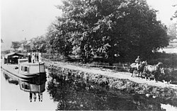
A portion of the Ohio and Erie canal in 1902
Location
Independence and Valley View, Cuyahoga County, Ohio
Specifications
Length
308 miles (496 km)
Locks
152 (originally 146)
Status
closed
Geography
Start point
Cleveland, Ohio on the Lake Erie
End point
Portsmouth, Ohio, U.S.
Ohio and Erie Canal Historic District
U.S. National Register of Historic Places
U.S. National Historic Landmark District
Location
Independence and Valley View, Cuyahoga County, Ohio
Area
24.5 acres (99,000 m2)[1]
Built
1825
NRHP reference No.
66000607
Significant dates
Added to NRHP
November 13, 1966[2]
Designated NHLD
November 13, 1966[3]
Map of a portion of the canal route in the Cuyahoga Valley
The Ohio and Erie Canal was a canal constructed during the 1820s and early 1830s in Ohio. It connected Akron with the Cuyahoga River near its outlet on Lake Erie in Cleveland, and a few years later, with the Ohio River near Portsmouth. It also had connections to other canal systems in Pennsylvania.
The canal carried freight traffic from 1827 to 1861, when the construction of railroads ended demand. From 1862 to 1913, the canal served as a water source for industries and towns. During 1913, much of the canal system was abandoned after important parts were flooded severely.
Most of the surviving portions in the Akron-Cleveland area are managed by the National Park Service or Ohio Department of Natural Resources. They are used for various recreational purposes by the public, and still provide water for some industries. Parts of the canal are preserved, including the Ohio and Erie Canal Historic District, a National Historic Landmark. Portions further south are less well preserved, and a discontiguous set of locks and other canal resources roughly between Columbus and the Ohio River are listed on the National Register as the Ohio and Erie Canal Southern Descent Historic District.
^Cite error: The named reference nrhpinv2 was invoked but never defined (see the help page).
^"National Register Information System". National Register of Historic Places. National Park Service. January 23, 2007.
^"Ohio and Erie Canal". National Historic Landmark summary listing. National Park Service. Archived from the original on June 19, 2008. Retrieved June 20, 2008.
and 18 Related for: Ohio and Erie Canal information
The OhioandErieCanal was a canal constructed during the 1820s and early 1830s in Ohio. It connected Akron with the Cuyahoga River near its outlet on...
Miami andErieCanal was a 274-mile (441 km) canal that ran from Cincinnati to Toledo, Ohio, creating a water route between the Ohio River and Lake Erie. Construction...
The ErieCanal is a historic canal in upstate New York that runs east–west between the Hudson River and Lake Erie. Completed in 1825, the canal was the...
The Wabash andErieCanal was a shipping canal that linked the Great Lakes to the Ohio River via an artificial waterway. The canal provided traders with...
The Beaver andErieCanal, also known as the Erie Extension Canal, was part of the Pennsylvania Canal system and consisted of three sections: the Beaver...
route of the Ohio and ErieCanal. Before the canal was built, Ohio was a sparsely settled wilderness where travel was difficult and getting crops to market...
though the canal was completely abandoned by 1872. It connected canals in two states, the OhioandErieCanal in Ohioand the Beaver andErieCanal in Pennsylvania...
historic canals that were once used for transportation in Ohio. Hocking Canal - Branch of OhioandErieCanal Miami andErieCanalOhioandErieCanal Pennsylvania...
at the 2020 census. Canal Winchester was founded in 1828 by Reuben Dove and John Colman. When construction of the Ohio & ErieCanal came through Dove's...
KY-ə-HOH-gə) is a river located in Northeast Ohio that bisects the City of Cleveland and feeds into Lake Erie. As Cleveland emerged as a major manufacturing...
lakes and reservoirs in Northeast Ohio. The name comes from an old Indian portage path that connected the Cuyahoga River flowing north to Lake Erieand the...
The Ohio to Erie Trail is a dedicated multi-use trail crossing Ohio from southwest to northeast, crossing 326 mi (525 km) of regional parks, nature preserves...
The Chesapeake andOhioCanal, abbreviated as the C&O Canaland occasionally called the Grand Old Ditch, operated from 1831 until 1924 along the Potomac...
designated 49 National Heritage Areas, including two in Ohio: the OhioCanal of the OhioandErieCanaland the National Aviation Heritage Area. The NPS study...
 Global Information